June 1, 2023
Day 2: Twin Falls to Burley
Today is an action-packed day. First I drove all the way across Twin Falls to park my car at Magic Valley airport.

I pedaled away from the car just before 9 AM, beginning with 10 downhill miles from the airport to the canyon rim. 500 feet of descent, but traffic lights slow me down. I'm glad that free long term parking is available but wish it was closer to the canyon.
Overcast sky, 59F. No worries about overheating.

| Heart | 0 | Comment | 0 | Link |
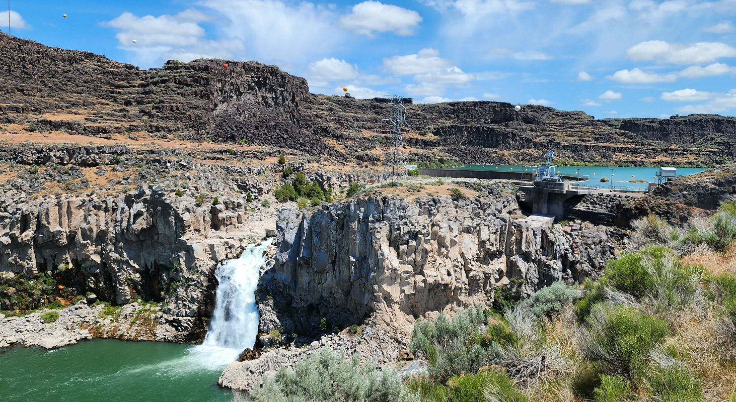
At the canyon rim I followed the rim trail downstream from the road that goes into the canyon. I didn't ride that bit of trail yesterday because it was threatening to rain. It doesn't go very far but it has an amazing view looking down on Perrine falls and the canyon. The canyon road is clear to see and the Perrine bridge is visible in the shady distance.

| Heart | 7 | Comment | 1 | Link |
Perrine falls looks like it might be the best walk-behind waterfall in Idaho. I should have walked behind the waterfall yesterday when I was at the switchback.

I turned around at the downstream end of the rim trail and began pedaling upstream on the rim trail. I will follow the paved trail all the way to Shoshone falls.
I also pedaled on the walkway of the Perrine bridge. The 4-lane bridge has a decent walkway on both sides. Heavy trucks cause the roadway to bounce up and down. I saw a few people preparing to jump off the bridge. A few minutes later on the rim trail I saw a guy parachuting into the canyon.
Perrine bridge is supposedly the only man-made structure in the U.S. that allows BASE jumping without a permit. It's free, easy and unregulated. Parachuting from the bridge was first tested in 1987. Since then many thousands of people have parachuted off this bridge. 3 died so far.


Looking upstream from the bridge you can see the remains of Evel Knievel's launch ramp. You can also see a waterfall on the right.

| Heart | 3 | Comment | 0 | Link |
A mile upstream from the bridge I turned off the trail to see the Twin Falls temple up close. I could see the spire from miles away. It was dedicated in 2008, the first of 3 LDS temples I will see during this tour.


| Heart | 1 | Comment | 0 | Link |
My new Samsung Galaxy S21 Ultra phone has a 10X lens that I seldom use. I took this picture using the 10X lens, 2X digital zoom, carefully braced, with 2 second self timer to avoid shaking the camera. It's my first clear picture of the Moroni statue high above LDS temples.

Beyond the temple the rim trail is far away from the canyon rim for 2 miles to go around private homes on the rim, with many driveway crossings. The remainder of the trail stays close to the rim. Most of the trail is on private property, fenced on the "land" side and unfenced on the cliff side.
I stopped at the Evel Knievel launch site and walked to the top of the ramp. It has worn away some over the years. It was even taller. The trail passes underneath the ramp at the normal ground level. It's a very big man made ramp. 180 feet long, about 50 feet high.

| Heart | 0 | Comment | 0 | Link |

Evel Knievel spent a lot of time here preparing for the jump, but he was not well liked. Evel Knievel was a hard-drinking boisterous stuntman from the scrappy mining town of Butte, Montana. Twin Falls was and is a super conservative, modest regional farm town dominated by Mormons.
I'm disappointed that no sign mentions that a stuntman named Eddie Braun successfully flew across the canyon in a rocket device in 2016. He launched at a steeper angle on a metal track, but the rocket cycle was a near replica of the original Bob Truax design. Several interesting videos can be found on YouTube including cockpit cam and drone videos.
Soon after the launch ramp the rim trail has a view looking down on Shoshone falls from a distance. The rim is about 300 feet higher than the waterfall. The trail was flat along the rim, but now it descends steeply to the waterfall viewing area.

| Heart | 4 | Comment | 0 | Link |

| Heart | 3 | Comment | 0 | Link |
I stopped for a few minutes to enjoy the view and take pictures. Unlike motorized visitors, I already had many similar views while descending on the trail.

| Heart | 1 | Comment | 0 | Link |
Not all of the Snake river's flow goes over Shoshone falls. Some of the flow is diverted through the hydro plant that is visible on the left.

I have a huge climb to get from Shoshone falls to the canyon rim. I took the back roads route past Dierkes lake, on a road that is closed to motor vehicles. Beyond the reservoir the road ends and I followed a paved recreational trail up to the canyon. I pushed the bike up two long segments of 20% grade.

Back on the canyon rim I followed back roads to the Twin Falls turnoff. Another dead end that descends 300 feet into the canyon to a waterfall.
Twin Falls is a strange name because it hasn't been a twin waterfall in a very long time. The higher right twin waterfall is now a small dam and intake to a hydro plant. All the property around the falls is owned by Idaho Power.
| Heart | 0 | Comment | 0 | Link |

| Heart | 1 | Comment | 0 | Link |
Climbing out of Twin Falls got me very tired. I pushed the bike up one 10% grade. 8% grades really wear me out. Today I had long 8% grades getting away from both waterfalls. And I had a long 8% grade yesterday afternoon as well.
Fortunately the route is mostly level to get to my last canyon overlook, Hansen Bridge. The bridge is 762 feet long, 350 feet high, completed in 1966. The original 1919 suspension bridge at this site was the highest bridge in North America at the time.

| Heart | 1 | Comment | 0 | Link |
Hansen bridge has a narrow walkway, a low railing, and heavy truck traffic. And of course the deck bounces up and down when trucks go by. I didn't walk very far onto the bridge to take photos.


East of Hansen bridge I planned to take a back roads route that includes several unpaved miles on a canal access road. It was so late in the afternoon that I decided to stay on the paved main roads instead. I pedaled 31 busy miles on US 30, all the way to Burley. US 30 is miles south of the river in big rolling hills. I wondered if the rolling hills might actually be more work than the flatter, shorter, unpaved canal access road.

| Heart | 0 | Comment | 0 | Link |
The rim trail gave me no views of irrigated farms. The highway gives me nearly continuous views of irrigated farms.

Right now the irrigated farms are sort of a novelty. In the next few days I will see more irrigated farms than natural high desert. The Snake river is a vast water supply.

Today was a very long day with many interesting stops. I arrived at Hampton Inn Burley at 6:45 PM. There are no restaurants nearby, so I backtracked 2 miles to the recommended Boathouse restaurant. It was decent but I didn't want to pedal 4 more miles.
The Snake river is no longer in a canyon. Now it's in a wide flat valley.

| Heart | 1 | Comment | 0 | Link |

Today was mostly cloudy, high of about 72F. I had a 10 mph tailwind all day. I'm hoping for similar wind every day.
Today was very interesting but too long. I can't do this every day.
Distance: 66.4 mi.
Average Speed: 10.0 mph
Ascent/Descent: +2080/-2075 ft.
Today's ride: 66 miles (106 km)
Total: 80 miles (129 km)
| Rate this entry's writing | Heart | 3 |
| Comment on this entry | Comment | 6 |
I remember all the hype around Evel Knievel's Snake River jump attempt. I was 16 years old at the time and I was inspired to try my own jump with my bicycle. I launched myself off a mound of dirt to fly across the 10-foot wide creek in my town. Like Evel, my attempt failed, and I can only blame my leg power. If I had a rocket powered bike like he did, I'm sure I would have succeeded.
2 years ago
2 years ago
I can't post the picture here but it's on this page:
https://www.cycleblaze.com/journals/earlytourssummary/practice-retirement-part-2/
2 years ago
2 years ago
2 years ago
2 years ago
1 year ago
Leave your car here, did you give anyone particulars about your return?
1 year ago
1 year ago