In Tombstone: Gleeson Road - Looking Back With 2020 Vision, Part I - CycleBlaze

January 29, 2020

In Tombstone: Gleeson Road

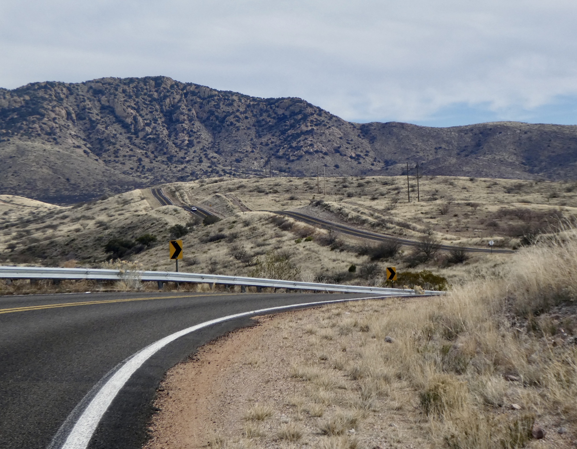
Today’s ride is the reason we’re in Tombstone for two nights.  When I started scoping out this tour, Gleeson Road looked like one of the most promising spots in the region for a day ride.  Beginning from Tombstone it bears southeast for about 30 miles, cuts through a low gap in the Dragoon Range, and terminates at the junction with Highway 191 in the center of Douglas Basin.  From the satellite view, it looks well paved the whole way, and virtually untraveled.  Perfect, if true.

It’s true.  Great ride, great day.

Note: today’s video was posted late, so we’re posting it here so return readers don’t have to go fishing to find it.  Also, Rachael wants it noted that the sound track refers to today’s terrain, not to either member of Team Anderson.

Video sound track: Over the Hill, by John Hiatt

The big buffalo watches over at the OK Cafe.
Heart 1 Comment 0
Ocotillo and saddle, Allen Street Inn.
Heart 5 Comment 0
Leaving Tucson, eastbound on Gleeson Road.
Heart 3 Comment 0
The Dragoon Mountains flank the eastern side of the basin, and our route skirts the southern end of the range. This is Apache country: Cochise’s stronghold is just on the far side of Mount Glenn, the high point in the range.
Heart 3 Comment 0
No cars, no fences, big vistas. Team Anderson Country.
Heart 5 Comment 3
Ron SuchanekLovely. Looks like Grumby country there.
Reply to this comment
4 years ago
Scott AndersonTo Ron SuchanekSorry. It’s ours. We got here first. It is a pretty large space though. For a fee we could consider sharing it - say for the indefinite loan of a bottle opener.
Reply to this comment
4 years ago
Ron SuchanekTo Scott AndersonHmm, you drive a hard bargain, pardner.
Reply to this comment
4 years ago
Gleeson Road climbs gradually for seven or eight miles until reaching its high point at 5,200’. Then it rolls along the top of the ridge for a few miles, threading its way through a gap.
Heart 3 Comment 0
The whole road is very scenic, but the best miles are right here, at the top.
Heart 2 Comment 1
Putting those empties to good use in Gleeson, a populated place.
Heart 1 Comment 0
Gleeson, a virtual ghost town, began life as Turquoise but was renamed when John Gleeson registered a claim and opened the Copper Belle Mine.
Heart 2 Comment 0
Read the fine print.
Heart 2 Comment 2
Jen RahnHuh? Maybe to protect themselves from dangerous touring cyclists?
Reply to this comment
4 years ago
Scott AndersonTo Jen RahnAs good a theory as any. We decided not to test it.
Reply to this comment
4 years ago
In Gleeson. A few people still live here, but it emptied out quickly after the mine played out in the 1930’s.
Heart 1 Comment 0
Remains of the Copper Belle Mine, presumably.
Heart 0 Comment 0
Remained of the Copper Belle Mine.
Heart 1 Comment 0
East of Gleeson, Gleeson Road gradually drops for about fifteen miles into Douglas Basin, eventually ending at the small community of Elfrida. Across the basin rise the Chiricahua Mountains.
Heart 1 Comment 7
Bill ShaneyfeltThere is a really interesting desert research center up in the Chiricahuas. If you get a chance it would be a neat place to visit. Can get cold and wet up there this time of year though, as evidenced by all the green.

https://www.amnh.org/research/southwestern-research-station
Reply to this comment
4 years ago
Scott AndersonTo Bill ShaneyfeltWe haven’t been to the center, but we did take a day ride through the Chiricahua’s on our first our through here. Spectacular area!
Reply to this comment
4 years ago
Bill ShaneyfeltSpecial place with Colorado Desert, Chiricahua Desert and Sonoran Desert all coming together in the sky islands area. Biological diversity is incredible.
Reply to this comment
4 years ago
Kelly IniguezI've been following along your Arizona route with great interest. I loved touring there the past two winters. This coming summer we will overnight in Elfrida. Any details on the town?

From there we will follow 191 north on The Comanchero Trail. Oren has just discovered our planned day from Morenci to Hannagan Meadows is a 10,000 foot climb. !

Kelly
Reply to this comment
4 years ago
Scott AndersonTo Kelly IniguezWe didn’t go through Elfrida on this tour, but we did back in 2016 (A Short Southwestern Sojourn, blogged here). We didn’t stay there though -is there lodging there, or are you camping? Instead, we stayed at Dreamcatcher B&B, on 181 east of Sunizona. From there, we followed 181 and 186 to Wilcox, north past Fort Grant on the way to Stafford, and then East to Duncan. After that we dropped south to Lordsburg, so I can’t really comment on the road north of Duncan.

In summer? Yow!
Reply to this comment
4 years ago
Kelly IniguezWe are leaving the instant school is out. If summer heat is already upon us, Oren and I will cycling at daybreak. Jacinto is a lizard - it is never too hot for him.

Plans are to ride from Naco, AZ north to Waterton Lakes, AB - roughly 2500 miles through the Rockies.

No camping, all motels. We are soft. :)
Reply to this comment
4 years ago
Scott AndersonTo Kelly IniguezNot so soft, I’d say. I read up on your plans on the other channel, and it looks ambitious enough. Not so sure about that motel in Elfrida though - it’s the only motel I’ve ever seen with a perfect rating on Trip Advisor - everyone thinks it’s worse than horrible. You really might consider Dreamcatcher (info@dreamcatcherbnb.com) instead. Nice place, and they’ll prepare a fine dinner and breakfast if you plan it in advance. Wayne Estes also stayed there on one of his tours. And, the ride up 181/186 to Wilcox is beautiful, passing beneath the Chiracahuas.

Good luck with Jacinto’s recovery! Rachael t-boned a German Shepard years ago, which was probably better Than hitting a cat - the dog absorbed a lot of the shock and slowed her down before she went over.
Reply to this comment
4 years ago
After sitting on the dusty shoulder of the road for a quick lunch, we turn west again and retrace our tracks.
Heart 1 Comment 0
Looking back east behind us toward the Chiricahua Mountains, we’re surprised to see how dark the sky is growing. It’s a good thing we turned back when we did. Weather changes fast, brings no guarantees.
Heart 1 Comment 0
Back on top, looking northwest. Much fairer ahead than behind.
Heart 3 Comment 0
Yucca seed pods
Heart 4 Comment 0
The wind has really picked up, it’s getting colder, and the sky behind us keeps darkening. With still ten miles to cover, we’re feeling just a bit anxious.
Heart 2 Comment 0
Back in Tombstone, we look back on our route. It’s raining back in the gap.
Heart 2 Comment 0
Biking down Allen Street today, it’s hard to imagine that during its boom years Tombstone had 110 saloons, 14 gambling halls, an opera house, three newspapers, two banks, and its fair share of dance halls and brothels.
Heart 4 Comment 0

Video sound track: Tombstone, by Roger Rabalais 

Sundown on Allen Street
Heart 5 Comment 1
Jen RahnSuch moody lighting!
Reply to this comment
4 years ago
The old Cochise County courthouse. Tombstone was the county seat until it was moved to Bisbee in 1929.
Heart 2 Comment 0
Heart 0 Comment 0

Ride stats today: 42 miles, 2,400’; for the tour: 1,454 miles, 72,500’

Today's ride: 42 miles (68 km)
Total: 1,454 miles (2,340 km)

Rate this entry's writing Heart 7
Comment on this entry Comment 1
Ron SuchanekI'm curious to hear more about Tombstone, but I'll wait until our HAC meeting later this month.
Reply to this comment
4 years ago