January 5, 2020
At Borrego Springs: San Felipe Road
After breakfast I bike out to the airport to pick up our rental car, and then drive back to the hotel where Rachael is waiting at the curb with her bike, both suitcases and the panniers. We’ve got a standard sized SUV to keep us company for the next two weeks. It feels like such a huge vehicle, but we need it. As it is, it’s a bit of a challenge fitting in two large suitcases and two folded bicycles.
And, it’s a bit of a challenge just driving the damn thing. First off, I haven’t been behind the wheel of a car for four months. Mostly though, it’s a challenge because new cars are so different than the simple, stick shift Jetta we’ve been driving for the past 20 years. So much new technology! GPS. Back up camera. Push button starter. Steering wheel warmer, for Pete’s sake.
And, we’re not orienting ourselves to all of this on some quiet county road. We’re starting off in downtown San Diego, and merging on to the freeway a few miles after leaving the hotel. We have to shift gears quickly here, folks.
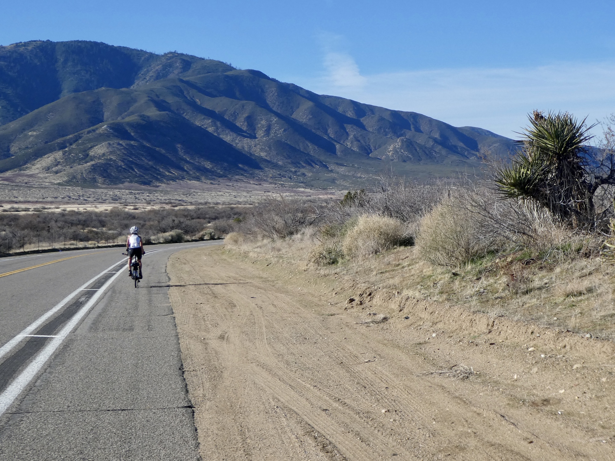
Half an hour later though we’re still alive and unscarred, climbing East through the foothills toward Ramona and beyond, anxiously eying the narrow, unshouldered road and the surprisingly heavy weekend traffic. I’m sure glad we’re not biking this thing; I’m not really even all that comfortable driving it. Our plan for the day is to park at one end of San Felipe Road and bike to its other end, but we’re wondering if it will be safe.
When we arrive though, it looks perfect. For the first time, there’s a broad shoulder and the road is marked as a bike route.

| Heart | 4 | Comment | 0 | Link |
We’ve ridden San Felipe Road before, on our Christmas Day ride down from Wynola to Borrego Springs. We began that day in a near freezing fog, but by the time we arrived here the fog had burned off, we were thawed out, and we enjoyed a spectacular ride the rest of the way. I’m going to save a bit of time here, and just reuse the way I described this road four years ago:
Route S2 is an absolute cycling delight. It comes with a lot of history, following the route of the old Southern Emigrant Trail that brought many early settlers to southern California. They came this way for the same reason we have today - it provides the lowest elevation passage of the Peninsular Ranges. The scenery is spectacular, there is very little traffic, and there is a lovely 6 foot shoulder for its entire length. It's a ride I would love to repeat someday.
The route begins with a gradual climb up Warner Valley to the high point, Teofulio Summit (recently renamed from Warner Pass to honor a member of the Mission Indians who homesteaded near here). From there it is a fast, beautiful 1700' drop to the end of the road, transitioning from green oak woods at the top to the arid Anza Borrego Desert at the end.
It’s just as fine a ride today, with a couple of exceptions. First, it’s much warmer, and we’ll even work off a sweat climbing back up to the pass on the return to the car. Second of course, today’s ride is an out and back so we’ll ride it differently. Rachael will keep her own steady pace, and I’ll stop here and there with the camera. She’ll reach the end of the road before me and turn back, so I miss the final mile and a half of the road.
Looking back at the earlier ride, I think I did a fine job taking photos then - maybe better even, I’d say. I could have saved even more time by keeping my camera pocketed, stayed with Rachael, and just reused the photos from last time along with the narrative.
The big difference though is the traffic. There’s almost none going in our direction, but many vehicles pass going the other way. Something like 80% of them are hauling some sort of off road vehicle behind them, apparently returning from a weekend or long holiday break down by the Salton Sea. This might be about the busiest day of the year on this normally quiet road.

| Heart | 4 | Comment | 0 | Link |

| Heart | 2 | Comment | 0 | Link |

| Heart | 2 | Comment | 0 | Link |

| Heart | 3 | Comment | 0 | Link |

| Heart | 2 | Comment | 0 | Link |

| Heart | 2 | Comment | 0 | Link |

| Heart | 1 | Comment | 0 | Link |

| Heart | 2 | Comment | 0 | Link |

| Heart | 3 | Comment | 3 | Link |
5 years ago
5 years ago


| Heart | 1 | Comment | 0 | Link |

| Heart | 1 | Comment | 0 | Link |
We meet up and pull off on the shoulder to sit on the rocks to eat lunch before the long climb back up to the pass. It’s nearly ten miles back up to the top, but not a bad climb at all. Surprisingly though, Rachael keeps falling well behind me. We talk about it at the summit once she catches up with me, and she’s really struggling. Has a side ache, is really having difficulty with the climb, is discouraged. Fortunately, it’s all downhill from here.
Back at the car, we’re folding the bikes and discover that her rear tire is very low, maybe flattening. She says she noticed that the ride was feeling bouncy but just assumed it was the chip seal road. No wonder she was struggling! I thank her for riding it out so we didn’t have to fix a flat on the road. We’ll take a look at it in the morning, but I suspect she got thorned at our lunch spot. Not the best omen for a two week stint in desert country.

| Heart | 1 | Comment | 0 | Link |

| Heart | 3 | Comment | 0 | Link |

| Heart | 2 | Comment | 0 | Link |


| Heart | 1 | Comment | 0 | Link |

| Heart | 1 | Comment | 0 | Link |

Back in the belly of the Whale again, we drive on to Borrego Springs, down Montezuma Road. We didn’t take this approach last time, so it’s a new road to us. And it’s astonishing. A steep, twisting three thousand foot drop to the Anzo-Borrego Desert, with a spectacular view with each new bend in the road. It’s especially dramatic late in the day, with shadows creeping up the slopes of the mountains. It looks like an awesome ride, assuming we decide it’s safe enough to bike and we have the stamina for it. It would probably go easier with air in the tires.
And, we have great video for today’s ride to show you, someday. The WiFi at our place in Borrego Springs isn’t solid enough to upload it though, so you’ll have to wait. This will probably be the case for the next two days, and almost certainly when we get to Death Valley as well. In fact, I’m not sure we’ll have WiFi in Death Valley at all, so don’t be surprised or concerned if the journal goes dark for a few days.
Some late breaking news: I spoke too soon. We have video?
Video sound track: The Lawnmower Song, by Eric Tingstad

| Heart | 1 | Comment | 0 | Link |

| Heart | 2 | Comment | 0 | Link |
Ride stats today: 33 miles, 2,400’; for the tour: 671 miles, 29,500’
Today's ride: 33 miles (53 km)
Total: 671 miles (1,080 km)
| Rate this entry's writing | Heart | 6 |
| Comment on this entry | Comment | 5 |
I left the desert in 1970 and really miss it. That is one of the reasons I started following cycle touring journals.
5 years ago
5 years ago
5 years ago
Though, I vote for mostly live snakes seen from a safe distance.
5 years ago
5 years ago