October 24, 2023
Moundsville I
Roundtrip from Wheeling

| Heart | 1 | Comment | 0 | Link |
It's good to be back in Wheeling! Since the last excursion from here (in July), I've been busy taking care of tasks on the home front, doing some rides, and completing Stage 7 (the final stage) of a cross country tour. A window opened up recently, so I returned to Wheeling with the weather on my side and headed South on the Heritage Trail.

| Heart | 0 | Comment | 0 | Link |
From the Heritage Port Area, the trail runs South for an additional 44 blocks, to Water Street. At that point roads were the only choice to go further south. I preferred the quiet and hilly varieties to the flat but busy highway (Route 2) along the Ohio River.
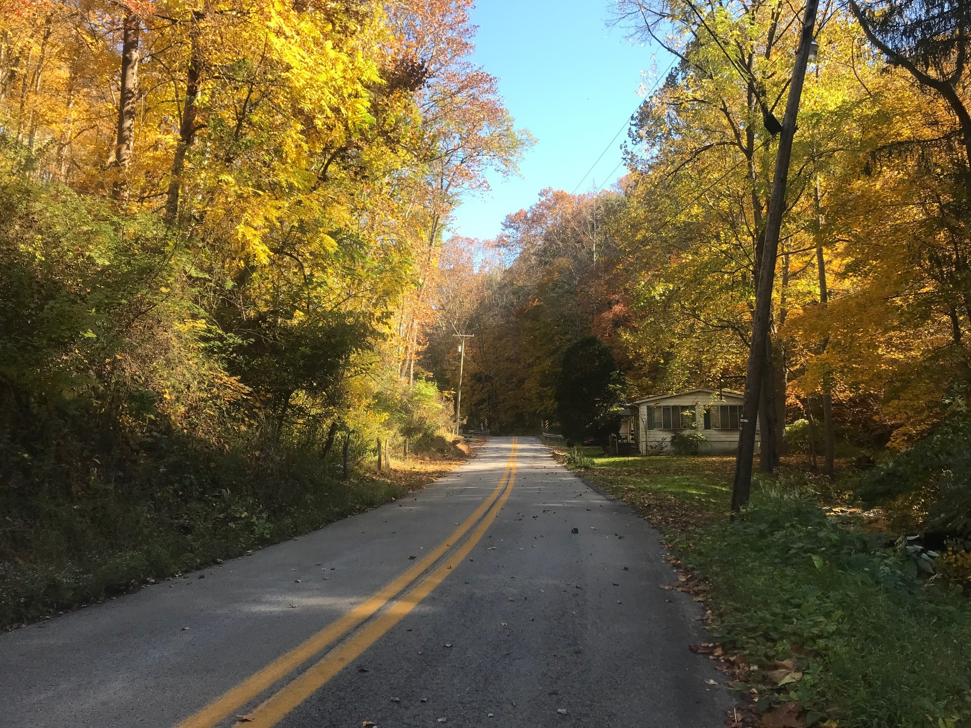
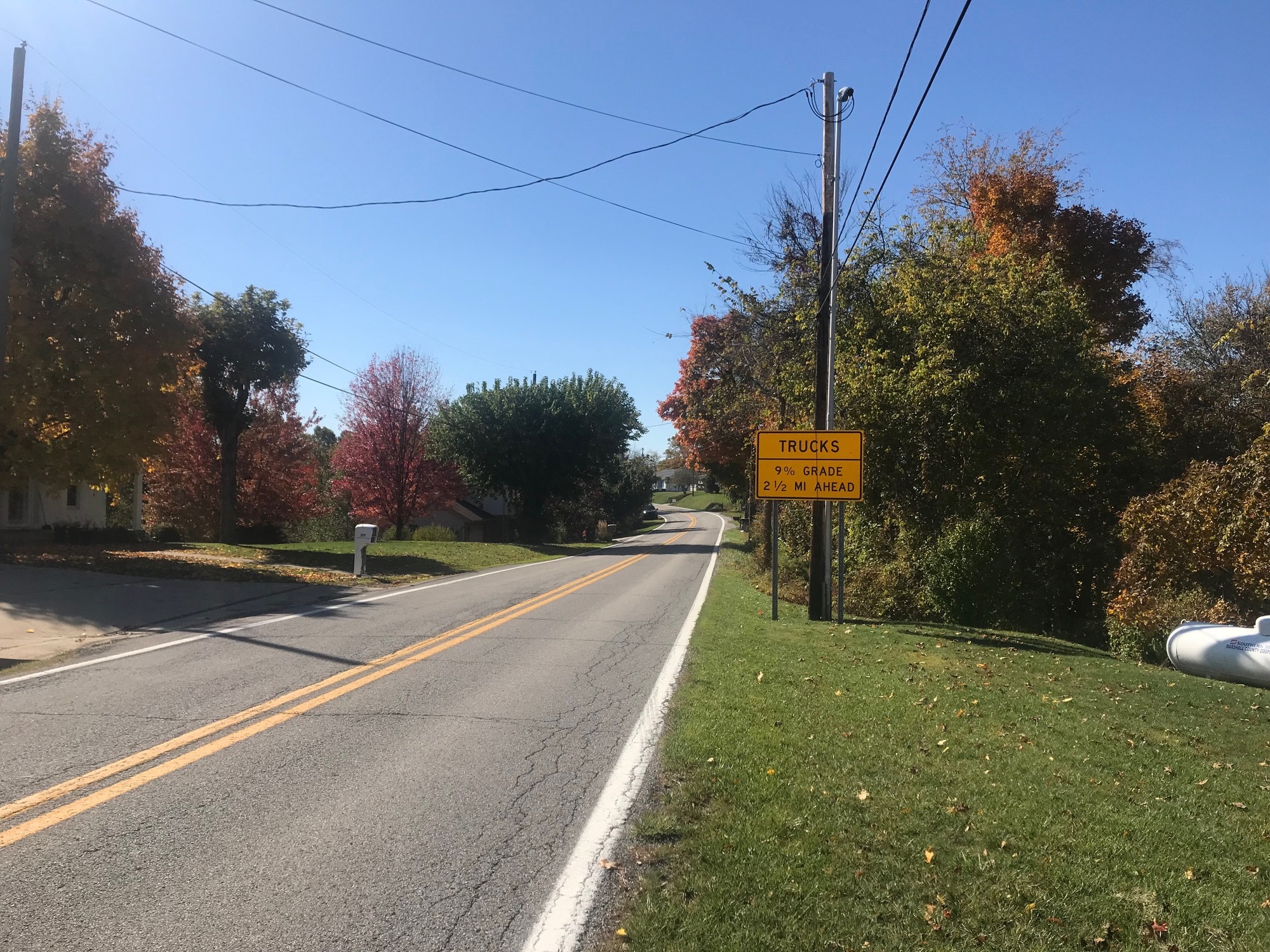
From the Heritage Port Area, the trail runs South for an additional 44 blocks, to Water Street. At that point roads were the only choice to go further south. I preferred the quiet and hilly varieties to the flat but busy highway (Route 2) along the Ohio River. Roosevelt Road went under the highway, out of Wheeling, and into Benwood, where its name changed to Boggs Run. From there, it climbed easily for most of the ascent to WV-86. Although the last 3/10ths of a mile were a bit steeper, I would not classify this as a difficult climb. Very few vehicles came by while I was riding and the autumn leaves were beautiful. After taking a right on WV-86, I had more "company" that was powered by fossil fuels. Most of them were courteous to me. The area was generally more open and the terrain more rolling. The pattern continued for a few miles until the big drop, down into Glen Dale, came along.

| Heart | 0 | Comment | 0 | Link |
At Glen Dale, I crossed US-250/WV-2 and went into the town, looking for access to the Glen Dale-Moundsville Trail that is shown on the map. My cue sheet directed me to what was a private road into a trucking company yard. I elected not to follow the GPS but rather to stay on Baltimore Street until reaching the Southern end of town. I didn't see any other access paths or streets.
So, once the Southern city limits of Glen Dale were reached, I had no choice but to brave the highway. Fortunately, it had 4 lanes so the drivers could move over. Most did so in plenty of time and I didn't get much attitude from anyone.
According to subsequent research, using the West Virginia trails website, the trail does exist. It is described as being 3.4 miles long and paved. Access points are (1) near Fokker Field, in Glen Dale, take Baltimore Street to Marx Lane to a left onto Railroad Street [which I believe I did and came up empty] or (2) in the Moundsville Riverfront Park, at the end of 13th Street. However, a look at the map shows the trail beginning at 10th Street. Since I am not yet done touring Moundsville, I will check these trailheads out during my next visit.

| Heart | 0 | Comment | 0 | Link |
At Moundsville, the shoulder widened and the road split into a business route off to the left and a continuation of the main route slightly to the right. I stayed to the right. Thankfully, the shoulder, which convinced me to stay the course, continued and the traffic seemed to abate. At 4th Street, I turned left and went up into town to see a few of the major attractions.
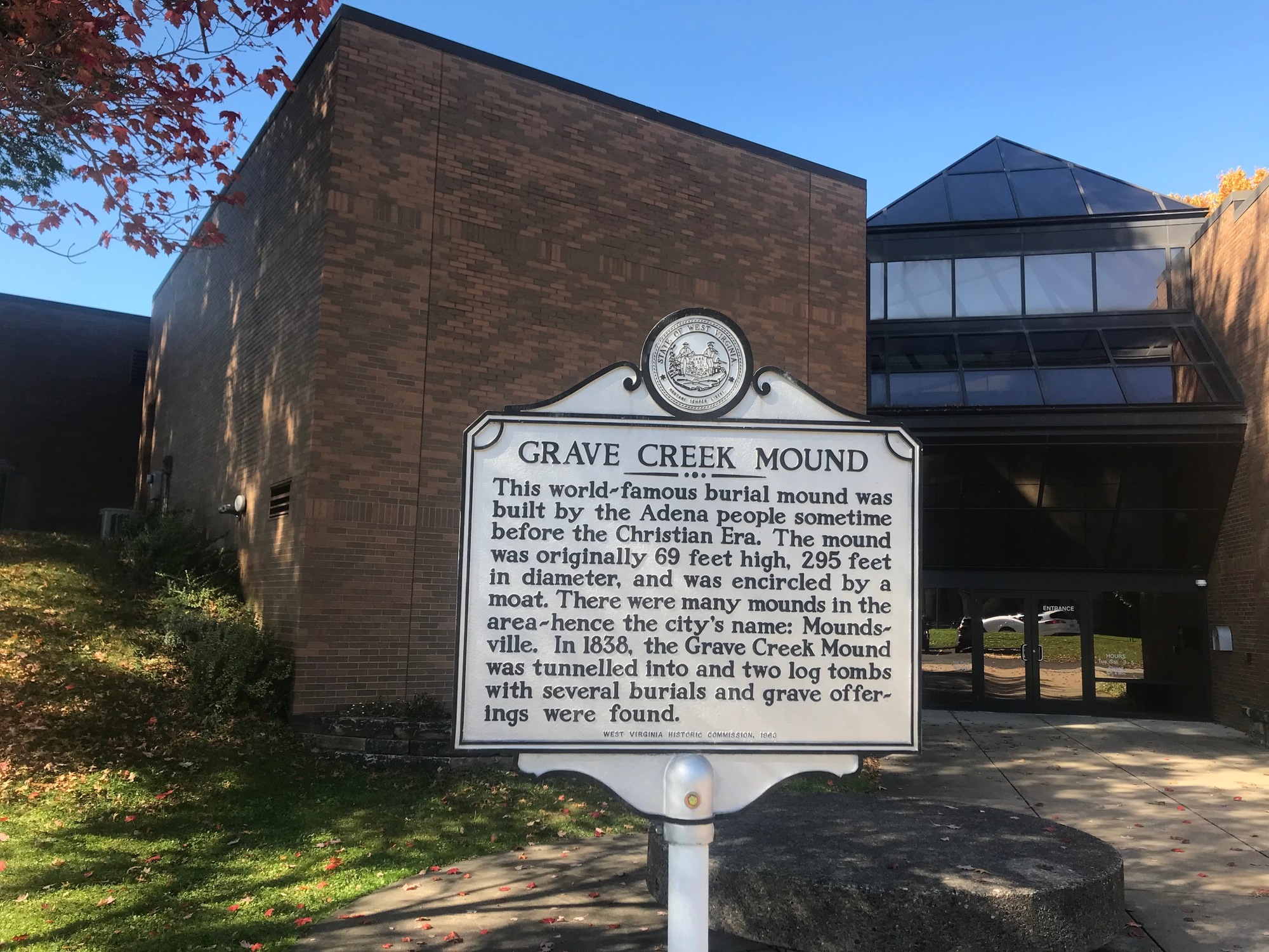
For a relatively small city, Moundsville has some interesting sites to visit. On Jefferson Street, the Indian burial mound, known as Grave Creek is something to see. Thousands of years ago, the Adena People buried their dead in tombs that were built up instead of digging down into the earth. There are burial mounds all over this area and extending into Southern Ohio. The Grave Creek Mound is one of the tallest at approximately 63 feet in height. I didn't scale it on this trip but did do so, with my family, several years ago. From its summit, there is a commanding view of the Ohio River and the surrounding area.

| Heart | 0 | Comment | 0 | Link |
Across the street, lies the now closed West Virginia State Penitentiary. The massive gothic structural complex operated as a prison from 1866-1995. Today, it is still open as a historical museum and for tours. At this time of year (Halloween), people are allowed to spend the night in the supposedly haunted jail. I know some people who have done this and was told it does get creepy in there at night. After having had an office for 13 years, at a similarly styled Penitentiary, I've seen enough of the inside of these places to have satisfied any curiosities I might have had.

| Heart | 0 | Comment | 0 | Link |
From the jail, I went up into town to see the Fostoria Glass Museum on Tomlinson Avenue. It was closed until Wednesday (this was Tuesday), so I had to settle for a photo of the front of the place. As was mentioned in earlier chapters of this journal, glass-making was a huge industry all over the area. Today, most of the old plants are all shut down, with the exception of Homer Laughlin's plant in Newell.
I made a visit to the area back in the late 1980s. An old memory of a defunct glass-making plant, that seemed to be within walking distance of the prison, is in my head. The Fostoria Glass Company ceased operations in 1986. The facility I remember seeing had begun to decay but still had evidence of its former self. Very likely, it was the Fostoria Plant. There are some online historical articles about the company, with photos of decaying structures, from 2006. Sometime between then and now, the plant was completely demolished. Sine there wasn't anyone around to ask about it on this day, I guess I'll have to come back again to take the tour and ask a few questions.

| Heart | 0 | Comment | 0 | Link |
There are a few more attractions to see in Moundsville, but since I got a late start today, I needed to begin the return trip to Wheeling. Those places will have to wait for another day. On the way back, I took the highway to Glen Dale. At the aforementioned split, in Moundsville, the shoulder ended but there was a sidewalk, so I used it. Only 1 pedestrian was met along the way and it was at a point where there was plenty of room for both of us. In Glen Dale, I was able to go into town and use Tomlinson Street to avoid the highway and get through town.
This is a good time to discuss the significance, to this area, of the Tomlinson name. Back in 1770, Joseph Tomlinson and his brother Samuel came to this area from Cumberland, Maryland. Samuel was killed in 1777 but Joseph remained and established deep roots that continue to this day. He discovered the Grave Creek Mound and claimed the land surrounding it. In an earlier chapter of this journal, I mentioned Tomlinson Run State Park that lies near New Cumberland, West Virginia. Suffice it to say that the Tomlinson's made their mark in this area.
While it would have been possible to return to Wheeling via the same roads I came down on, I elected to try another option. In retrospect and when making a recommendation to anyone else, I would advise using the hillier but safer "incoming" route. Portions of SR-2, along the river between Glen Dale and McMechen, are dangerous for a bicyclist. The road is a highway, has high posted speed limits, blind curves, and narrow to non-existent shoulders, in spots (on the blind curves, yikes!). Fortunately, although traffic was light and I had no trouble today, I don't recommend that anyone else try it.

| Heart | 0 | Comment | 0 | Link |
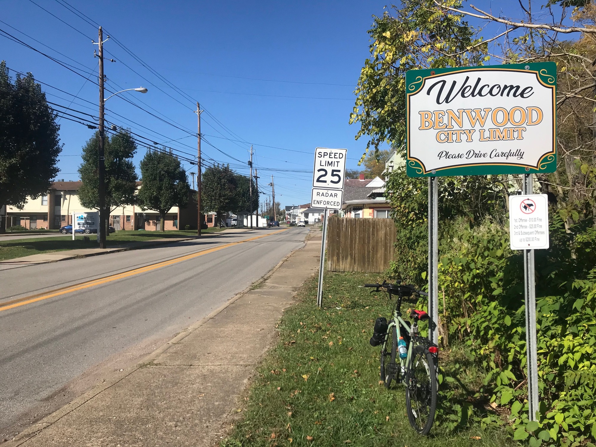
Thankfully, I was able to get off the highway within a couple of miles. After exiting, everything calmed down immediately. The tranquility continued all the way through McMechen and its northern neighbor, Benwood. The only real traffic I saw was due to school letting out. Several school busses and parents in vehicles picking up students, brought traffic to a halt. I was able to bail onto parallel streets to avoid the situation. McMechen and Benwood appear to be former industrial working class towns. They resemble other towns in this valley that have undergone similar downturns in fortunes.
In the Northern part of Benwood, the road I wanted to use had signs saying it was closed for construction. Taking a chance by continuing anyway brought me to some heavy equipment that completely blocked a road in the process of being torn up. I spoke to the foreman, who was a woman. To my good fortune, this very friendly and helpful supervisor had only recently been assigned to this project after having finished one up in neighboring Ohio. She literally walked (with) me through the entire construction zone while we had a very nice chat. Once there, I thanked her and was able to continue onward.

| Heart | 0 | Comment | 0 | Link |
Eventually, I reached a point where I had to get back on the highway. Fortunately, the on-ramp led to an off-ramp without ever merging onto the actual highway. A careful exit led me onto Boggs Run Road, where I had been at the beginning of my ride this morning. From there, I got back onto the Wheeling Heritage Trail (WHT) and had a nice ride back to my starting point. The afternoon temperature had risen into the upper 70s, of degrees Fahrenheit. A bit warm for this time of year but I'll take it. Being out on the bike today was a great place to be.
No map for this one because my XOSS Sprint stopped working during the ride and I had to recreate part of the route manually.
Today's ride: 32 miles (51 km)
Total: 377 miles (607 km)
| Rate this entry's writing | Heart | 1 |
| Comment on this entry | Comment | 0 |