September 28, 2020
In Rab: the hike to Kamenjak
Today’s ride
Last night was a replay of the previous two, with us wakened in the middle of the night with the crash of thunder, howling wind, and the hammering of rain on the windows. In the morning we would discover it took out the WiFi.
It’s dry in the morning though, and looks to be so until about noon. With an easy eight mile ride ahead of us we’re in no hurry to leave, so I bike down to the nearest cafe for coffee and to make use of their WiFi so we can check with today’s lodging to see if we can arrive early. No problem - the apartment is ready, and we can show up at any time.
We leave about ten. Not much to say about an easy eight mile ride, except that we converted it to ten by chasing an attractive side road that turned to gravel and mud after a mile so we backed out. We’ll let the video tell the rest of this morning’s short tale.
We arrive in Rab town about 11, and check in at the real estate office where we pick up the keys. The agent checks us in and then calls our hostess to alert her that we’ve arrived so she’ll be there to greet us. It’s a short two blocks away, but just as we leave the rains start. Even in this brief exposure it’s enough so that we’re getting wet by the time we arrive. We don’t have an address - the agent just pointed to a spot on the map - so we’re just starting to get anxious about locating it when we look up and see our host waving at us from a second floor balcony.

| Heart | 1 | Comment | 0 | Link |
Video sound track: Još Sam tu (I’m still here), by Lea Dekleva

| Heart | 1 | Comment | 0 | Link |
The hike to Kamenjak
After a few hours, the rains pass on. With most of the afternoon available, we study the map for walking ideas and find a hike for the ages. The climb to the lookout point at Kamenjak is a walk I’m sure we’ll be remeniscing over to the end of our days.
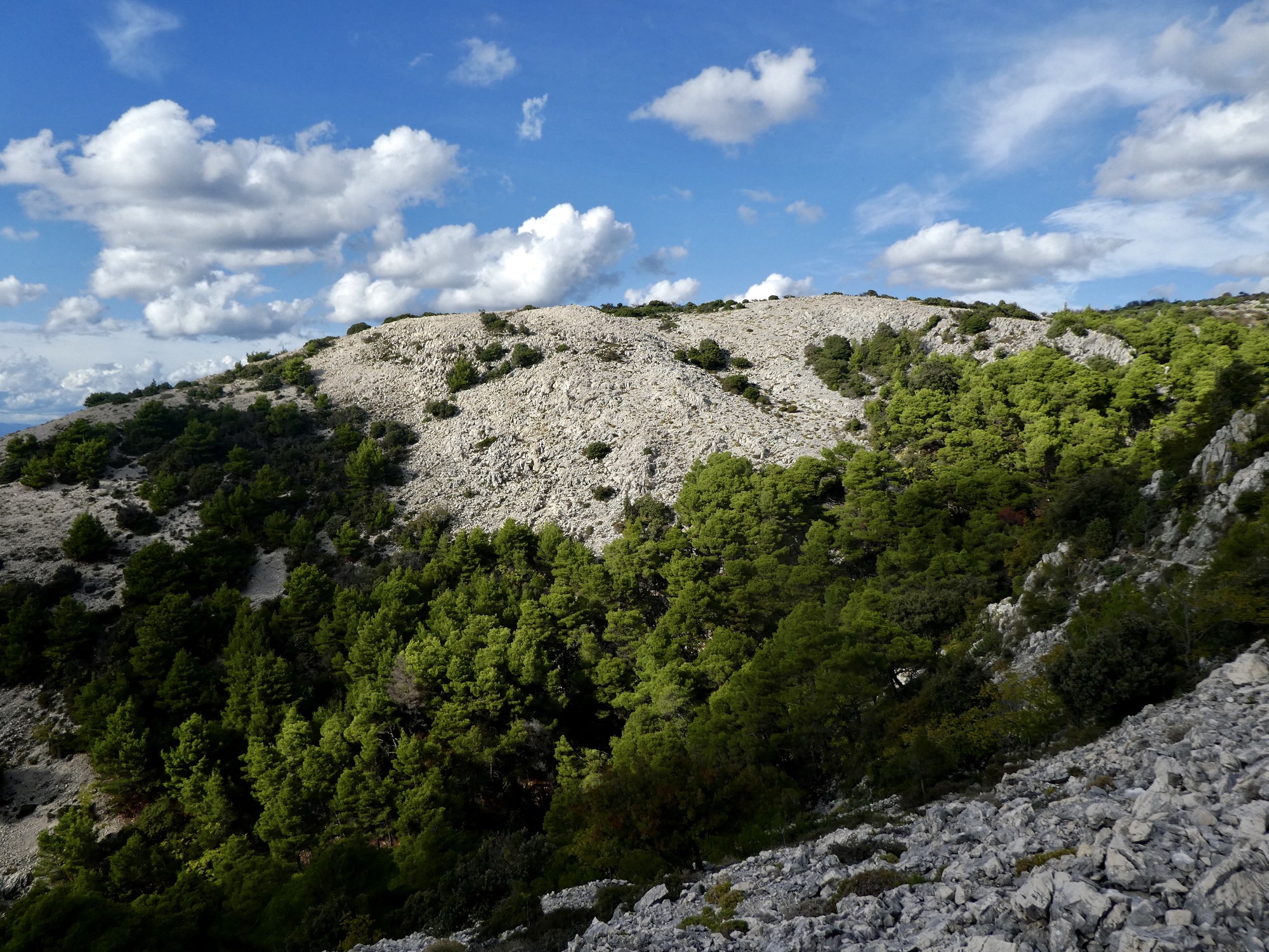
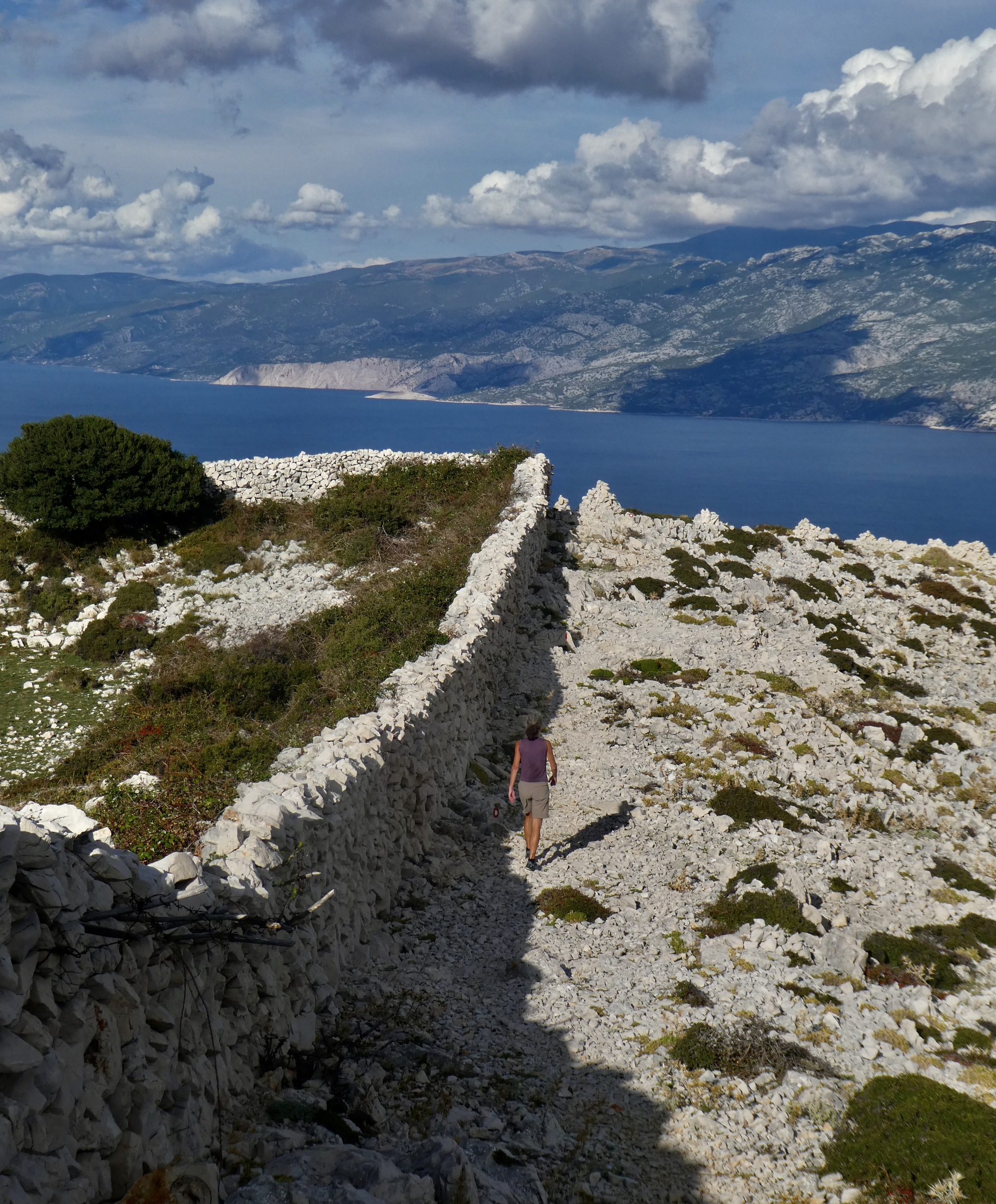
You’ll recall from the photo of our arrival in Lopar yesterday that the landward flank of the island is a steep, barren rocky slope. You can’t see this from most of the island because its on the opposite side of a high, steep ridge. There is only one place where any road reaches the summit of the ridge, and none at all on the rocky side itself. And it’s no wonder once you get up there and see the surreal barren karst expanse stretching below you, its surface criss-crossed with stone walls.
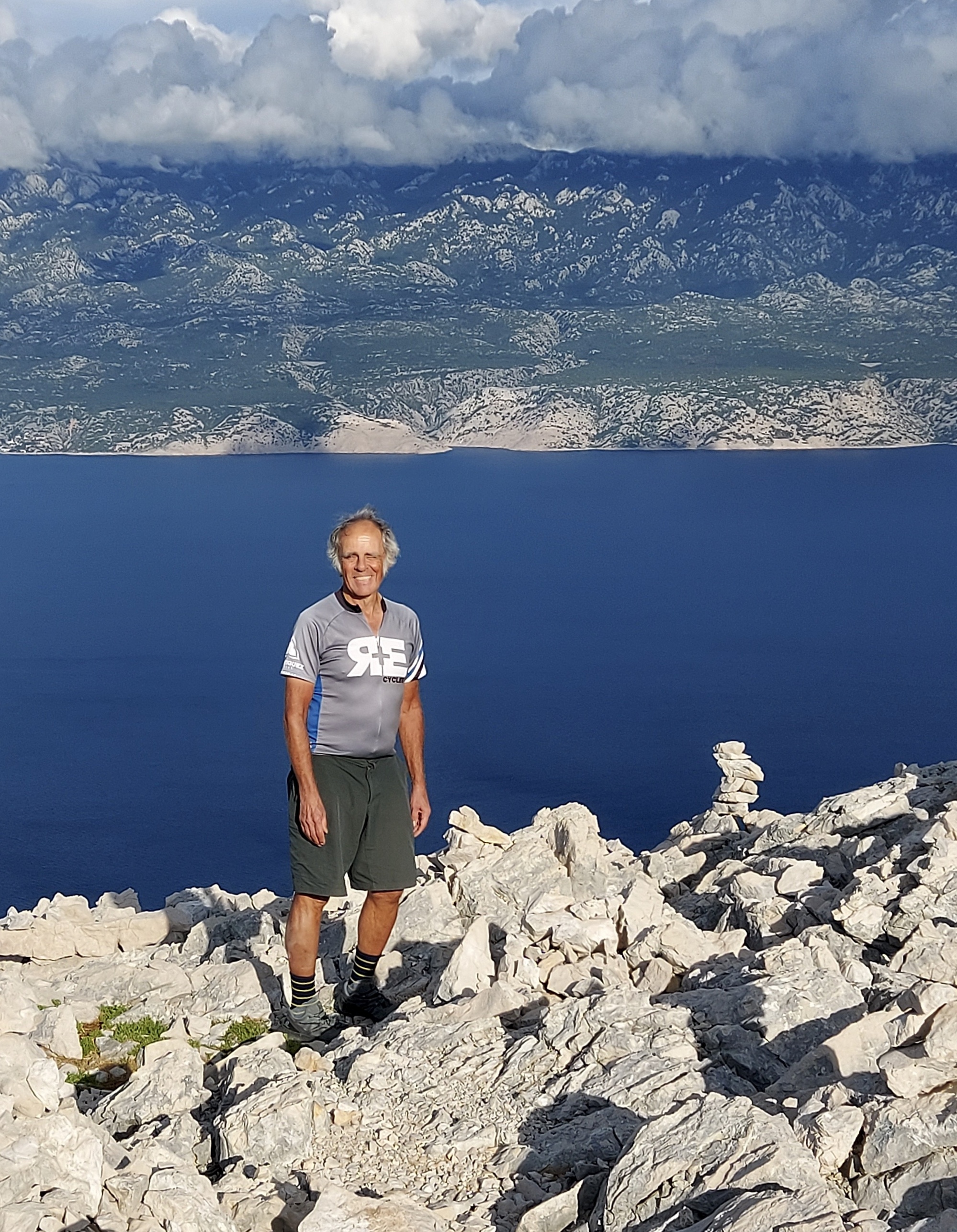
Our destination is Kamenjak, a 1,300’ high point at the end of the intermittently paved road that reaches the crown of the ridge. There’s a telecommunication tower at the top, so presumably the road exists to service it. You could bike up, but it’s steep the whole way. It’s much more suitable as a walk.
In addition to the road there’s a well marked hiking path that zigzags its way up the steep, wooded western slope. Our plan is to walk up on the path and then down on the road, which I’m thinking should be easier on my knees.
The walking path is great. It’s never as steep as it looks like it would be when viewed from below because it makes such a contoured run up the slope. In imagining this hike, my goal was to get to the top and see the other side; but the ascent itself made the hike well worthwhile in its own right.

| Heart | 1 | Comment | 0 | Link |

| Heart | 1 | Comment | 0 | Link |

| Heart | 2 | Comment | 0 | Link |

| Heart | 1 | Comment | 4 | Link |
Yes they do lose their tails when grabbed by a predator. It then escapes as the tail is devoured. It does re-grow, but the replacement is not as elegant as the original.
That one looks like it was recently lost and only slightly begun to regenerate.
https://www.inaturalist.org/taxa/55990-Podarcis-muralis
4 years ago

| Heart | 2 | Comment | 0 | Link |

| Heart | 2 | Comment | 0 | Link |


| Heart | 1 | Comment | 0 | Link |

| Heart | 2 | Comment | 0 | Link |
Toward the top, the climb tapers off considerably and we pass through a series of gates through fences that apparently control sheep movement near the summit. Suddenly, we crest the ridge and see what we came for - sublime views across the channel to Velebit, and beneath us the awesome karst landscape I’d been eager to see. It’s not a disappointment.

| Heart | 3 | Comment | 0 | Link |

| Heart | 4 | Comment | 0 | Link |


| Heart | 2 | Comment | 0 | Link |

| Heart | 1 | Comment | 0 | Link |
| Heart | 2 | Comment | 0 | Link |


| Heart | 2 | Comment | 4 | Link |
4 years ago
It looks like Jerusalem sage (Phlomis fruticosa).
https://www.gapphotos.com/imagedetails.asp?imageno=166820
4 years ago
4 years ago

| Heart | 4 | Comment | 0 | Link |
It’s getting late in the day and there’s still a three mile walk down a steep road ahead of us, so we get started. It’s easier walking, but also I’m glad we returned this way because the views are so spectacular, and different than we’ve seen before.
The walk is steep, but not too bad. I’ll make it down fine, but I’m happy to accept a lift from a couple stopped at a dramatic viewpoint of Rab town on the way down - nearly the only beings other than sheep we’ve seen since the hike began. It saves my knees a bit of strain, and even more importantly gets us in front of a menu about an hour earlier than would have happened otherwise.
And, it lets us have an interesting conversation with this couple on the way down. They’re German, and on a two week holiday. They’re spending nearly all of it in Rab, because it’s one of the few spots in Croatia where they can go without facing a two week quarantine when they return home.

| Heart | 2 | Comment | 0 | Link |

| Heart | 2 | Comment | 0 | Link |

| Heart | 1 | Comment | 0 | Link |
| Heart | 3 | Comment | 1 | Link |
Ride stats today: 9 miles, 700’; for the tour: 1,240 miles, 57,600’
Today's ride: 10 miles (16 km)
Total: 1,245 miles (2,004 km)
| Rate this entry's writing | Heart | 8 |
| Comment on this entry | Comment | 3 |
4 years ago
4 years ago