Spoilt for Choice...which route
There are multiple ways to cycle to Tamworth from Canberra. I'd like to avoid carrying a tent and cooking gear on this short tour so whatever route is taken, it'll need to include towns with accommodation.
And these towns will need to be rideable distances apart. This is not something to take for granted in Australian regional areas where space between settlements can be a long stretch on a bike.
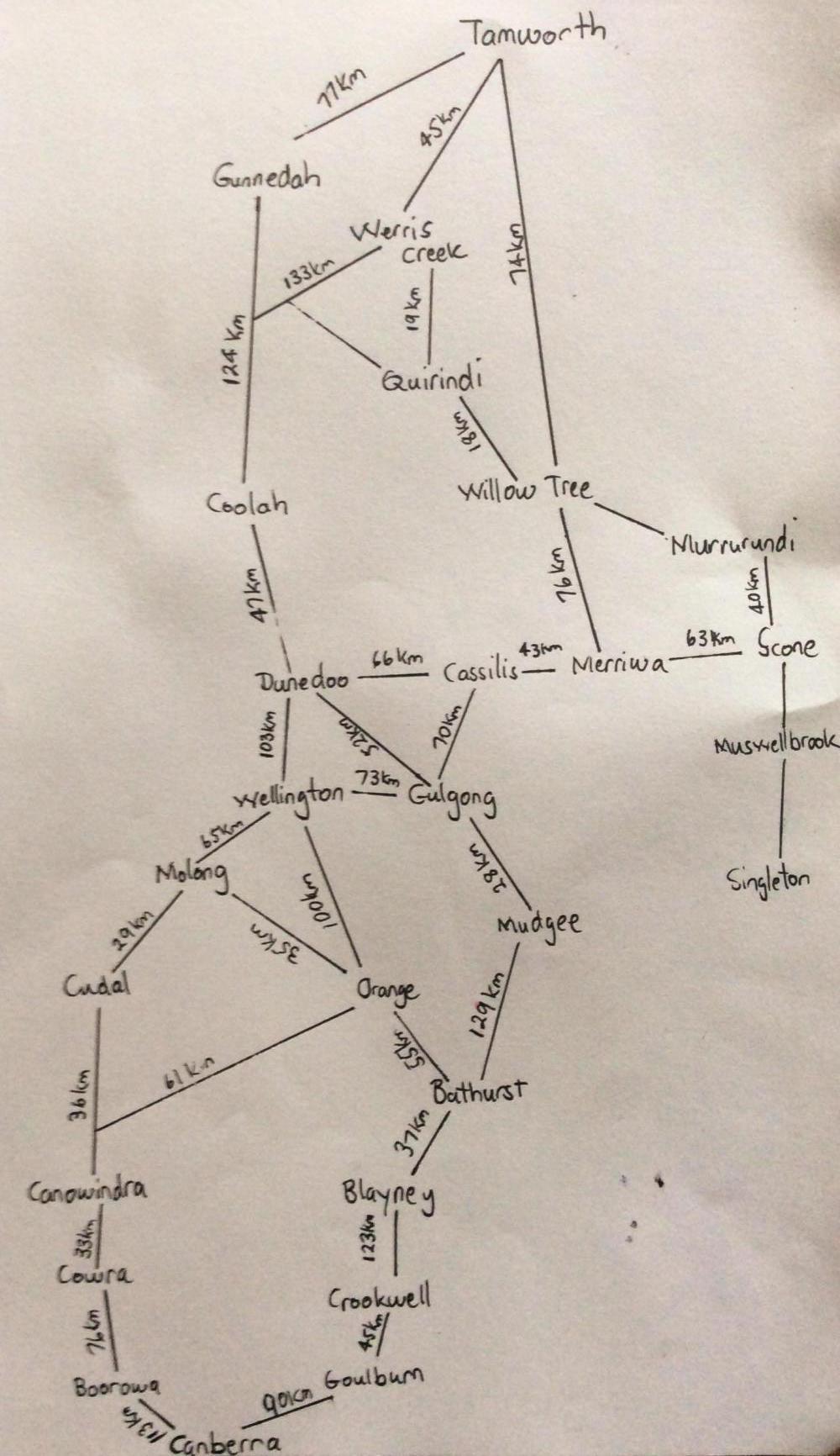
To help simplify choosing routes between roofed accommodation spots, I've made a quick sketch from proper maps. Not to scale and it doesn't show other routes closer to Sydney which I prefer to avoid on this ride.
The choices are many.
| Heart | 0 | Comment | 0 | Link |
There are two broad choices to make. Swing out to the west where it's flatter, or head more directly north and play in the hills a bit.
The flatter route is likely to have busier roads at the beginning of the ride, whereas the hillier route could mean busier roads mid-ride.
Decisions, decisions.
An overview of the topography helps with way finding. The image below shows the general area of the ride. Australia is supposedly the flattest continent, but it is remarkable how hilly it feels on a loaded touring bike and you can see from the satellite image that this ride will cross undulating country.

| Heart | 0 | Comment | 0 | Link |
Some of you will have noticed that dark green area on the satellite photo. That area (The Blue Mountains and Wollemi National Parks) is tough going on a touring bike so I'll be skirting by it on this ride.
American readers may be interested to know that Australia also has a Great Divide. Oddly though our Great Dividing Range isn't great, dividing or a range. It is many ranges and hilly regions spread over several thousand kilometres, and it is passable, but does require some care in route finding to avoid canyons and gorges.
Thanks to a map function enhancement here on CGOAB, I now know that:
One route (via Boorowra, Cowra, Wellington) shows a 3125 metre gain and a 3321 metre loss and a -196 metre net change.
The other route (via Gunning, Crookwell, Blayney) shows a 5356 metre gain and 5549 metre loss. That is a -193 metre change.
If choosing between a route with 3125 metres of climb, versus one with 5356 metres of climb, and the ride needs to fairly quick, the choice is clear.
The ride will go via the flatter course.

| Rate this entry's writing | Heart | 0 |
| Comment on this entry | Comment | 0 |