September 7, 2015
Day 15 ending near Versailles, IN
Up and working on report at 5:52am. Looked like it'd be another nice day. I had a short riding day planned for today - just needed to get to Versailles State Park near Versailles. I wanted to explore Clifty Falls before I left, but couldn't make up my mind to do it by bicycling or hiking. There's a tunnel here built by a railroad company that went bankrupt before they finished. That would be neat to see. And there's an observation tower to the south, near the Ohio River.
I finally decided to hike, rather than bike, and took off at 8:09am. The park's pamphlet had a good map showing numbered trails. I found the start for Trail 9 at the edge of the campground. Trail 9 would get me close to Trail 1, which goes to the observation tower. Trail 9 took me first to the swimming pool area. There was a group of wild turkeys ahead. One young one had, somehow, ended up inside the fenced pool area, and was walking back and forth, looking for a way out. I'd wished there was something I could do to help, but figured at least they'll let him out when the pool opens.
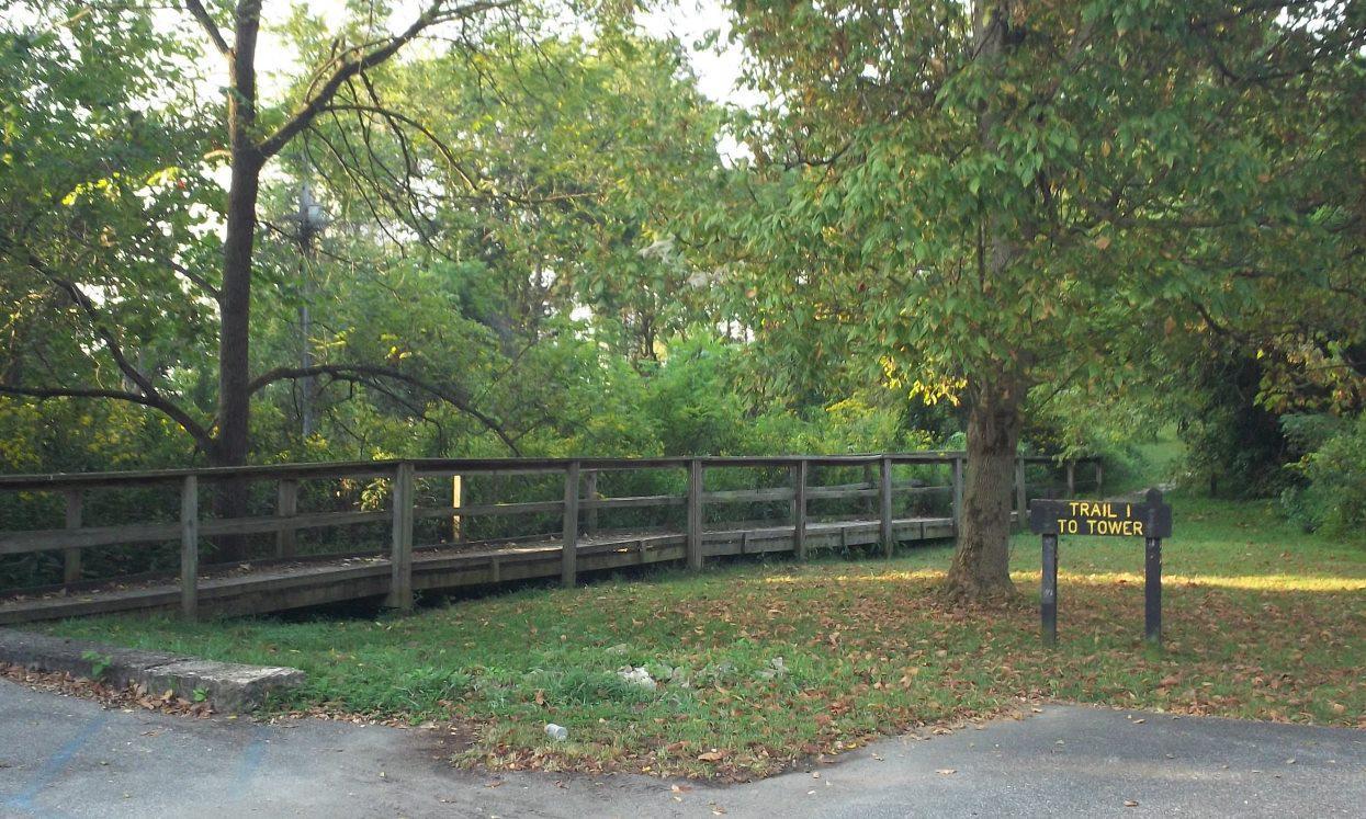
Made it to the observation tower at 8:55am. The tower isn't quite high enough to see over the trees, but it does allow for a good view of the smoke stack of a power plant. I'd seen this stack yesterday, a long ways back coming toward Madison. Here it was up-close. I think I could have seen the Ohio River if it hadn't been so hazy.
Trail 1 continues downhill at this point. My plan was to take Trails 1, 3, and 4 to Trail 5. Trail 5 was near the tunnel, which isn't too far away from the campground. I got on Trail 3 at 9:20am, and Trail 4 at 9:33am. Somehow along the way, I missed a turn, and ended up on Trail 2, which follows/is the creek bed to Clifty Falls. The map showed a way to connect up with Trail 5 ahead, so I could still get to the tunnel. Trail 2 is classified as 'Very Rugged', and it looked it. I started making my way upstream, up, over, and around rocks, boulders, and downed trees. Not much water in the stream bed, but pools here and there had small, minnow-sized fish.
This hike was more than I bargained for, trying to pick the best path through. I made it, however, and was suddenly at the base of the falls! I sure hadn't planned to be here. I must have missed that Trail 5 connection. I remember reading that there is no way out from the base of Clifty Falls, but to return as you came.
Back downstream I went. My 'best path' down was different in places than what I used going up. There was a rock-covered water run-off to my left - that must be Trail 5. I started up that. This was harder than the creek bed! I was quite a ways up when I saw that this "path" wouldn't get me out of this ravine. Back down and onto the creek bed. All this was turning into more adventure than I'd wanted for my two-hour outing. Now I just wanted out of this canyon!
Backtracking farther, I made it out of the creek bed, and back to the top to a road at 10:50am. Just before its batteries went dead, my PN-60 GPS indicated where I was now (Poplar Grove picnic area). Knowing that, I then realized that it wasn't Little Clifty Creek I'd walked up, nor was it at the base of Clifty Falls where I'd stood! Instead, I'd gone up Hoffman Branch to Hoffman Falls!
I figured out the shortest way back to the campground (Trails 10 and 9), and arrived at 11:28am. I'd missed seeing the tunnel, but had had an adventure. There is a laundry/vending machine building here, so I splurged, and bought breakfast. Get packed, get the tent down, and get going. One o'clock was my goal. I missed it by six minutes.
An easy, short ride today - almost all on US-421. I had to make it to this park's entrance/exit first, which I did by 1:25pm. I stopped at a Dollar General store while still in Madison to get more size AA batteries, and more Beanee Weenees and sardines while I was there. Also picked up a fruit popsicle to eat now. I packed the batteries away and hung the rest (double-bagged) from the flag pole. We'll see if that works.
At 2:11pm, I was on US-421. Straight and flat! Made it to Rexville at 3:40pm, and Correct at 4:42pm. Arrived at Versailles at 4:45pm, and the Dairy Queen there at 4:50am. I thought the DQ would have indoor seating, but it was outdoor seating only. Had a bacon cheeseburger, onion rings, and large mint shake. Done at 5:20pm.
Looking at the map, I wasn't sure on the best way to the park, so just followed my GPS waypoints. That brought me to the longest downhill of the trip so far - to Laughery Creek, and the covered bridge over it.
Arrived at the park's gatehouse at 5:45pm. No one was there. Checked at the nearby park office - no one. Proceeded on to the campground. This was uphill, as I'd expected. Arrived at the campground's gatehouse at 6:05pm. No one here either. Rode around some, and came upon the Camp Host. They can't collect the camping fee, but said set up anywhere and a park officer will stop by. Shortly after I selected site #105, the park officer did show up. I paid-up, then bought a 'Sprite Zero' from the pop machine here - it was the only pop selection not sold-out.
On to setting up the tent, a shower, and a phone call to my wife. The stars are bright tonight, and there are soft bug sounds. A great end to an adventurous day.
Jeff
Spent: $4 (breakfast from vending machines) + $11.14 (batteries, food, popsicle) + $10.56 (lunch) + $24.61 (campsite) + $1.75 (Sprite Zero) = $52.06.
| Heart | 0 | Comment | 0 | Link |
+ plus signs indicate pictures added after returning home from the trip +

| Heart | 0 | Comment | 0 | Link |


| Heart | 0 | Comment | 0 | Link |


| Heart | 0 | Comment | 0 | Link |

| Heart | 0 | Comment | 0 | Link |


Today's ride: 29 miles (47 km)
Total: 640 miles (1,030 km)
| Rate this entry's writing | Heart | 1 |
| Comment on this entry | Comment | 0 |