June 5, 2020
Day 9: Grants Pass to Sunny Valley
I got up at 6:30 because of the jet boat reservation. Walked to Black Bear Diner and found they were closed. Then I noticed that McDonalds allowed walk-in customers to order (unlike in White City). After breakfast I pedaled downhill past downtown to the Hellgate Excursions office. Arrived at 8 and many people were waiting already.
The office opened a few minutes later. They did temperature checks, questionaires, mandatory hand sanitizer, made sure everybody had a mask. I rolled my bike into their secure office area. That was nice of them. I don't think they could handle more than 1 or 2 bikes.
The dock is a couple blocks away from the office. The pathway is nicely landscaped. We all waited a long time. This is the first commercial trip of their reopening and they are still working out the details.

| Heart | 0 | Comment | 0 | Link |
This morning Hellgate Excursions is running their two largest boats for the 8:45 AM "Fast and Scenic" 2-hour excursion to Hellgate canyon and back. Everybody could fit on one boat but the social distancing rules don't allow that. Every other bench was left empty, and they needed several feet of empty bench between each party. The result was that my party of one used up a lot of bench space.
The first boat was loaded and departed 10 minutes late at 8:55. My boat left 15 minutes later after considerable rearranging to accommodate a tour guide's last-minute group of 10. Lots of waiting around before sitting on the boat for 2 hours.
Running the boats less than half full makes it hard for Hellgate Excursions to make a profit. Cheap fuel compensates a little bit. I hope they can make it work.

Once underway our boat went downriver quite fast and quickly caught up to the other boat. Cruising speed seems to be about 40 mph. My boat has 3 engines with more than 1500 total horsepower. It drafts 3 feet when stationary but only 8 inches at high speed. The boat must go fast in shallow sections.
The driver slowed down to let us look at the Applegate river flowing into the Rogue river. I wasn't expecting to see the Applegate river again. The driver estimated that the Applegate river flow was 100 cfs and the Rogue river flow was 3000 cfs.

It was a typical early June morning. Air temperature in the 60's, water temperature about the same. Wind chill was extreme when cruising at high speed. The driver seldom went fast for more than 5 minutes at a time. The wind really gets to you. I expected at least one passenger's mask to be blown off but nobody lost their mask.
The boat passes a few landmarks that I saw yesterday on the bike. There were occasional wildlife sightings. We saw an osprey, two bald eagles, great blue herons, and a beaver lodge.

The jet boat goes 18 miles downstream to Hellgate Canyon. The first half is in a wide valley. The second half gradually closes in with forested hills. The boat traveled slowly through the canyon's narrow but deep channel.

Hellgate Canyon is a very narrow rocky passageway for the Rogue river. When the river floods, the water goes way up in this area. The driver pointed out the Hellgate Canyon overlook 90 feet above. It was inundated during the 1964 flood.

Hellgate canyon is quite nice. You can't see it very well from the highway overlook. The jet boat (or a kayak) is the only good way to see it.

On the return trip there were fewer stops for informative speeches and more stops for boat acrobatics. About a dozen times the driver got the speed up to 30 mph and the spun the boat. The boat decelerates rapidly as it turns sideways. When it careens sideways the boat creates a big wave that soaks people on that side of the boat.
One time they did a 2-boat stunt. The boat ahead did a spin, creating a wave. My boat plowed straight into the wave creating spray that flew the entire length of the boat. Like hitting a wave in my kayak.
I'm glad I was able to do the jet boat tour on the last day of the bike tour. It's worth the $58 ticket price. I recommend it.
The boat returned at about 11 AM and I finally got on the road about 11:30. Today's distance is short but extremely hilly.

| Heart | 0 | Comment | 0 | Link |
Backtrack 2 miles uphill across Grants Pass. Cross I-5 and continue mostly north, uphill on Granite Hill road. The grade is gentle.

| Heart | 0 | Comment | 0 | Link |
The summit of Granite Hill road is 700 feet higher than the river. Grades are reasonable, no more than 7%. Traffic was moderate. The area is mostly rural residential.

Today is cooler and cloudier than usual. It was mostly sunny until about 10 AM. Then overcast for the remainder of the day but with no chance of rain. High temperature was only 71F with a brisk north wind.

| Heart | 0 | Comment | 0 | Link |
After a short descent I began another forested climb on Winona road. It climbs 700 feet and the top part includes 11 and 12% grades. Fortunately the steep sections were short enough that I didn't need to stop for air. Traffic was very light because it's mostly private timber land.

Then Winona road descends to Jumpoff Joe creek. Trees are dense enough that there are no panoramic views.


The final climb of the day is on Jacks Creek road. The first half mile is paved and not too steep. The grade is a steady 10-12% after the pavement ends. I was getting winded very quickly. Could only gain 30 feet elevation between 30 second stops. That wasn't working well so I decided to push the bike for most of the 1000 foot climb. I could do that without needing to stop every 2 minutes.


The gravel descent to Grave creek offered somewhat more open views of the valley below. The descent was only 7-8% grade. In the opposite direction I could probably pedal to the top.


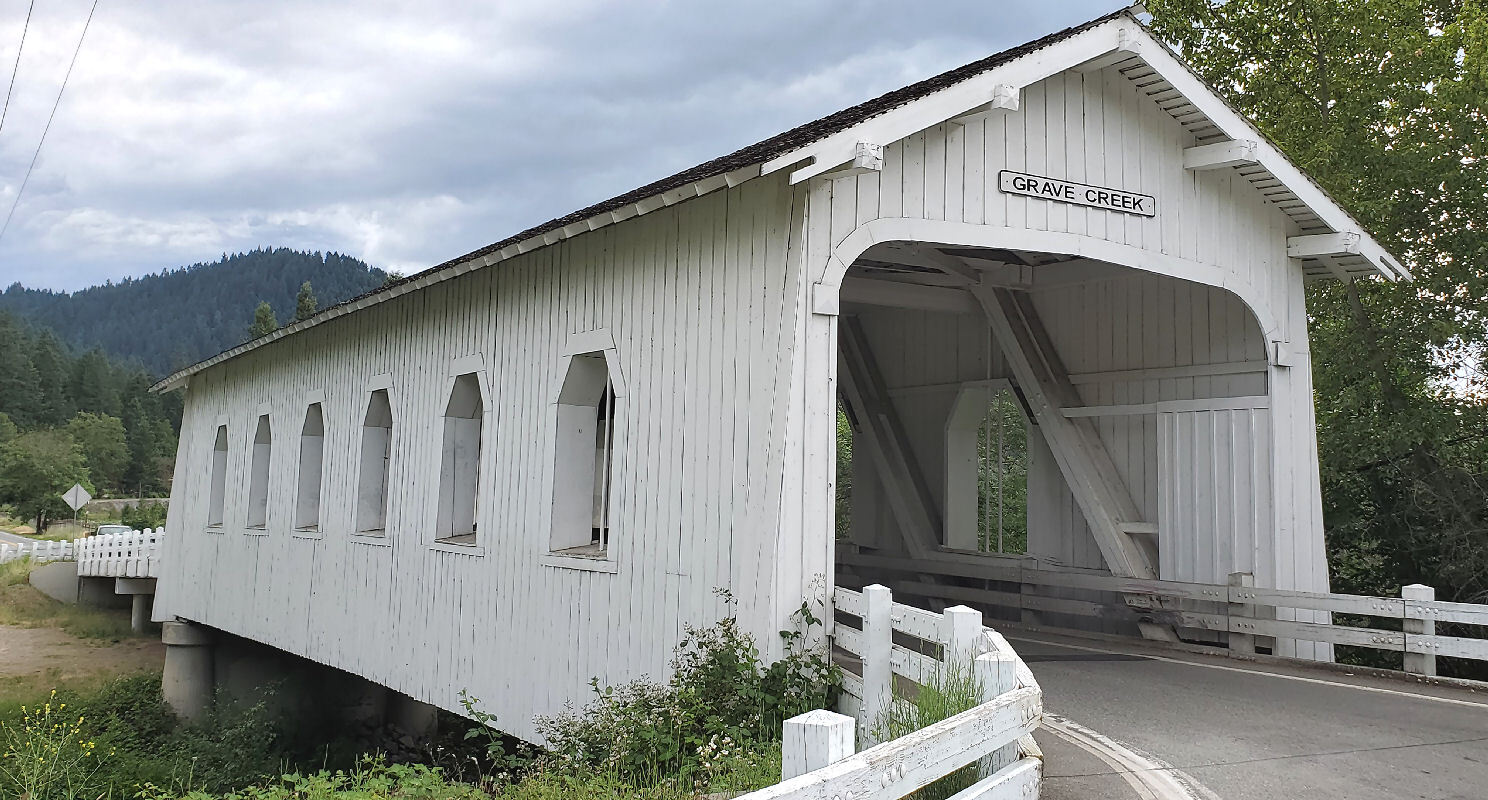
I stopped to have a long look when crossing Grave creek.

At the intersection in Placer I looked around for the Placer ghost town and found nothing that looks like a ghost town. No sign about a ghost town. I went a mile upstream to the end of the county road and saw no ghost town. I'll have to do some research to find the exact location. It must be up in the hills somewhere.
Placer is now about half rural homes and half cannabis farms with annoying tall fences. It's obvious that this sleepy community has changed significantly since the cannabis farms moved in. Josephine county is one of only a handful of Oregon counties that license cannabis farms. I don't see them in my county.
From my turnaround point at the end of the county road I pedaled 4 miles downstream along Grave Creek to the covered bridge. The final stop was at an unusual wood structure that was once a Grange hall.


I arrived at the Grave Creek covered bridge at 4:40 PM. Took a couple pictures, then went under the bridge to change into street clothes. My wife pulled into the parking area just as I got back to road level. It only took a minute to remove the panniers and drop the bike into her cavernous Subaru Forester.
On the way home we stopped at the next I-5 exit to have dinner at Wolf Creek Inn. We had never been there before. It looks great since a major renovation was completed a year ago. The inn was built in 1883, the same year my house was built. A tavern operated here for many years before the inn was built, going back to the early years of the Applegate trail.

| Heart | 0 | Comment | 0 | Link |

Today was arguably the most difficult day of the tour even though it was only 25 miles. It had the most climbing of any day and most of the climbing was unusually steep.
I ended the day feeling too tired to bike tomorrow. That's okay because I don't need to bike tomorrow.
Distance: 25.3 mi. (40.5 km)
Ascent/Descent: +2658/-2578 ft. (+810/-786 m)
Average Speed: 6.6 mph (10.6 km/h)
Today's ride: 25 miles (40 km)
Total: 324 miles (521 km)
| Rate this entry's writing | Heart | 2 |
| Comment on this entry | Comment | 0 |