Introduction
To avoid confusion I will begin by declaring that this bike tour journal has nothing to do with a famous 2009 biography of the same name. I did not read the book but I biked through Sarah Palin's home town of Wasilla, Alaska in 2015.

| Heart | 0 | Comment | 0 | Link |
Furthermore, this journal has nothing to do with the early 19th century original meaning of Going Rogue which refers to an elephant behaving violently.

Instead, this journal describes a 9-day motel bike tour in the Rogue river valley of southern Oregon, USA.
The Objective
The objective is to see the local sights, not to travel a long distance across the map.
I pedaled through the Rogue valley during 3 previous tours but only recently thought about doing an entire tour there. I assumed the Rogue valley is too small and not diverse enough to be an interesting destination on its own. Hopefully I can prove myself wrong!
The Route
The start/finish is 70 miles (112 km) south of my house in Sunny Valley, Oregon. Not far from home but it's a different climate zone. The hills surrounding my house are forested with Douglas Fir trees. In Sunny Valley the trees are Pines because there is less rainfall.
The Rogue valley has a population of about 250,000. It's generally good for bike touring but there is some traffic. The route avoids the largest town, Medford, and busy highways such as OR 62 and US 199. The towns aren't extremely far apart so it's easy for bike tourists to find services.
On the map below it's easier to visualize the route if you click the drop-down box in the upper right and select "Terrain" view.
The elevation profile graph shows that there are many hills but no big mountain climbs. The route stays mostly in valleys. The lowest elevation is 700 feet (213 m) when crossing the Rogue river in the northwest corner of the route. The route climbs above 2000 feet (610 m) elevation in five areas.

The schedule is fixed because all lodging was reserved in advance. Lodging varies from plush riverfront lodges in Grants Pass and Applegate to historic hotels in Ashland and Jacksonville. Overnights in Grants Pass, Rogue River, White City, Ashland, Jacksonville, Applegate (2 nights), then Grants Pass again.
The route includes two 5 mile unpaved segments, one easy and one very steep.
The River
The Rogue river is the largest of 3 rivers that flow from Oregon's high Cascades directly to the Pacific ocean. Nearly all of the Rogue watershed is in Oregon. A tiny portion is in California.
My route follows the Rogue river as far downstream as possible, crossing the river just before it enters the roadless Kalmiopsis Wilderness. The route goes up the Applegate river nearly to its headwaters, to Applegate reservoir. The route does not go very far up the Rogue river but on previous tours I pedaled the Rogue up to Diamond Lake and Crater Lake.
The map below shows the Rogue river watershed. My route stays in the middle third of the watershed. To the north is the Umpqua river watershed. To the east and south is the Klamath river watershed. All 3 rivers flow from the high Cascades to the Pacific ocean.

| Heart | 0 | Comment | 0 | Link |
The map also shows the major tributaries of the Rogue watershed. My tour is mostly along the Rogue and Applegate rivers but also goes along Grave creek, Evans creek, and Bear creek.
According to Wikipedia the name Rogue River began with French fur trappers who called the river La Riviere aux Coquins because they regarded the natives as rogues (coquins). I imagine the natives were judged to be scoundrels simply because they didn't cooperate with the fur trappers.
The Mountains
The route stays mostly in valleys that range in elevation from 900-1900 feet (275-580 m). It climbs into foothills several times but never climbs high into the surrounding mountains.
The biggest mountains are the Cascade range to the east with 9495 foot (2895 m) Mt. McLoughlin dominating the skyline.
To the south are the Siskiyou mountains which roughly parallel the Oregon-California state line. The dominant peak is 7533 foot (2297 m) Mt. Ashland.
To the west are the Klamath mountains which are taller and more rugged than the Oregon Coast range farther north, with many peaks above 4000 feet (1200 m) elevation.
Nearly all storms come to Oregon from the northwest or southwest. The Rogue valley is the driest place in western Oregon because it's in the rain shadow of the Klamath and Siskiyou mountains and because rainfall gradually decreases as you go south.
The Drought
Western Oregon is currently in a multi-year drought. The drought is most severe in the inland portion of southwest Oregon where this tour takes place.
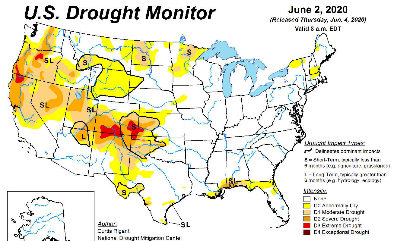
| Heart | 0 | Comment | 0 | Link |
The effects of the drought are minimal at the beginning of the dry season. The landscape is still fairly green, small creeks still have water, and there are no wildfires.
Drought is unlikely to cause trouble but there is another important factor to consider...
| Rate this entry's writing | Heart | 2 |
| Comment on this entry | Comment | 0 |