September 16, 2018
D13/H1: Bai'an to Zuoquan 白岸乡 → 左权县

Once I was done threatening the local police with a velvet gloved iron fist, I headed out to the bypass road in the hopes—having now done the road through Bai'An town four times (twice in each direction)—that the bypass was more interesting or at least less steep. It was definitely prettier so that was good but it's still new enough that the town hasn't started to ooze over and expand that way and, as a result, I started my trip up the mountain with nothing edible in my panniers other than the sugar for my coffee.
Although this was the sort of mountain to have a number of a stops where trucks could check their brakes and refill the tanks of water used to cool said brakes, none of the little shops I passed had anything to eat more appetizing that packaged chicken feet. I wasn't quite hungry enough for packaged chicken feet but lunch, when I got to the town just past the top of the mountain, was a very very welcome break.
About a third of the way up the mountain the widening and other upgrades which now made this road rideable stopped. I think it was still a bit wider than it had been in 2012 but it may have just been that I wasn't caught between the edge of the road and a fifteen foot drop off. Also, it wasn't until I was at least two thirds of the way up the mountain that I started getting much in the way of truck traffic coming down at me.

| Heart | 0 | Comment | 0 | Link |


Although I tended to come to a complete stop to let each individual truck or grouped caravan of trucks pass me by, the ones going down bothered me a great deal more than the ones going up. With trucks that were going up there was no worry that they'd suddenly have a brake failure and come—all twenty or thirty tons of them—sliding into me. I never quite got to the point of actually jumping off the road when faced by a truck taking a switchback wide as it came down but there were a few times when I kind of sort of wanted to but was equally worried that if I did anything other than stand perfectly still I might tangle myself up in my bicycle and end up in the behemoth's path.

| Heart | 0 | Comment | 0 | Link |

The restaurant at the top, where I had lunch, is my first time this trip that I've been accused of lying about being a foreigner. Given the current political situation going on in far western China, if I were from Xinjiang, it certainly would be safer for me to pretend to be foreign and, as I go farther west, I'm going to encounter more and more people who have met—or at least seen—curly haired, blue eyed, big nosed Chinese people. The not-really-very-hijab-like scarf which I wear to keep the worst of the road dust out of my hair probably doesn't help matters.

| Heart | 0 | Comment | 0 | Link |


| Heart | 0 | Comment | 0 | Link |


From the top of the mountain all the way to Guai'er Town [拐儿] was mostly downhill. Given the steepness of the eastward side of the mountains, it was funny how gradual a slope they had to the west. Even though I knew it would be gradual, I didn't really feel like taking the 7km detour to Tupeng Village [土棚村] and the tunnel which, back in 2012, I'd dubbed the "Hall of the Mountain King".
Being as I wasn't completely exhausted and hungry and desperate to get to anywhere that was a somewhere the way I had been on my way to Guai'er in 2012, I was able to stop at some of the villages on the road to Guai'er and check out architecture which—both in age and style—was similar to the cool stuff I'd seen six years ago in Tupeng.

| Heart | 0 | Comment | 0 | Link |


| Heart | 0 | Comment | 0 | Link |

| Heart | 0 | Comment | 0 | Link |


| Heart | 0 | Comment | 0 | Link |


| Heart | 0 | Comment | 0 | Link |

Back in 2012, there was a interesting site that wasn't a Site of Interest in that it doesn't show up on any maps despite actually being really damn cool and historical. Despite the amount of research I put into making sure my turnoff towards Guai'er was in fact on the right road (I mean, how can you forget a town literally named "Crutches") nothing really looked familiar about the road I was on and even if it was going to Guai'er, the simple fact of my having taken a different pass over the mountains meant that, maybe, just maybe, this was a different road which was going to take me to the same place.
Eventually, however, despite the passage of time to fade memories and the changing of the seasons to change the way everything looks, I got confirmation that I was exactly where I wanted to be.


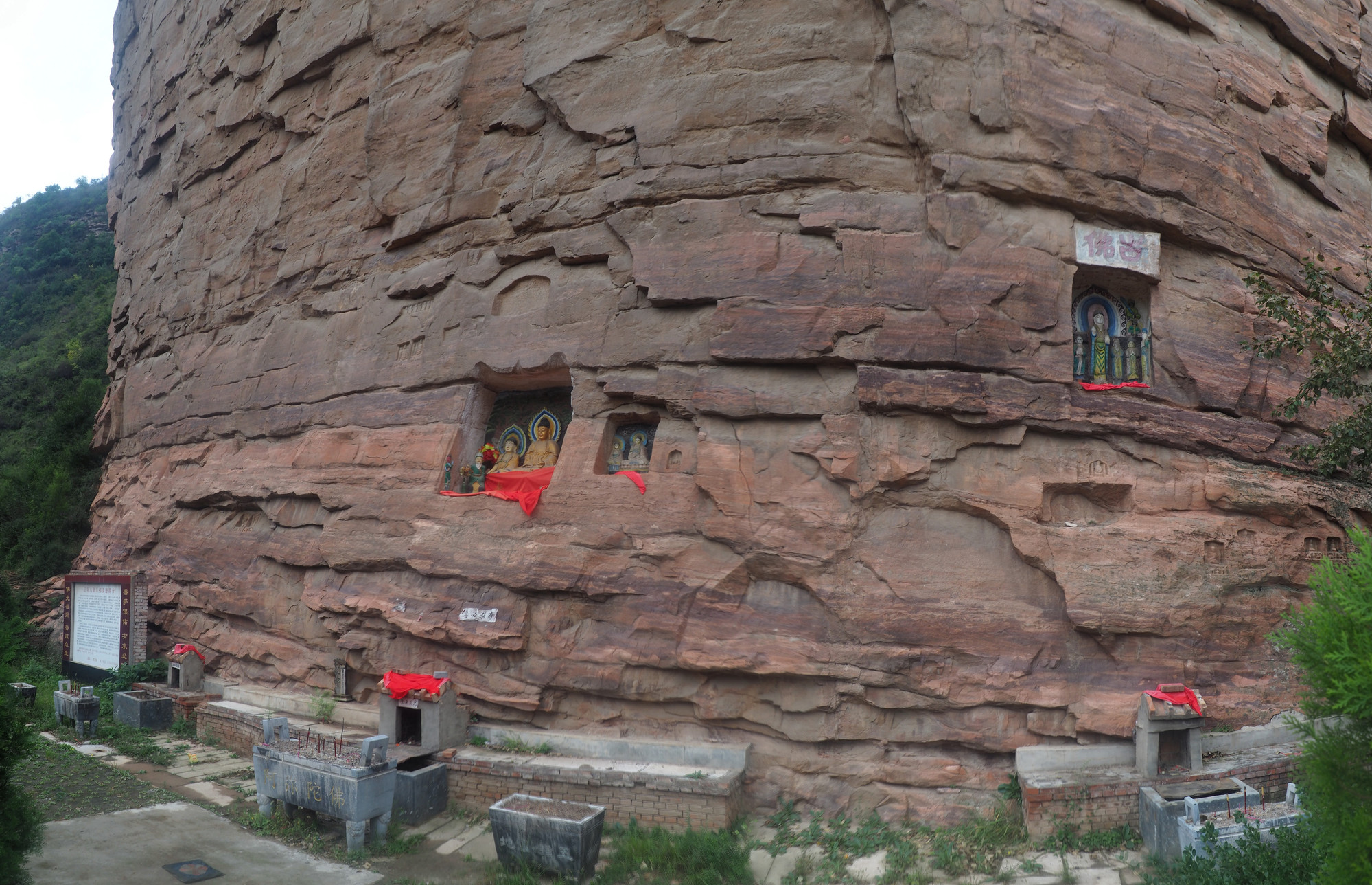
I could have sworn I spent at least an hour wandering around the cliff carved Buddhas and temple just before Guai'er climbing on top of things and taking pictures. According to the time stamps, however, it was more like fifteen minutes.
The sign at the site goes into great length about the folk tale based history of the cliff and the story of how the Japanese invaders were thwarted from bullying the residents of Guai'er back in the 1930s because of the Buddha cliff, but, other than that, there's nothing to indicate how old the carvings are. Based on artistic styles as well as the weathering and natural delamination of the rock, many of the carvings clearly come from different eras but, you'd have to know a lot more about this specific niche part of Asian art than I do to figure out which eras those are.

| Heart | 0 | Comment | 0 | Link |
Introduction to the Five Finger Mountain
The famous five finger mountain, also known as the handprint cliff, is located to 1.5 km northeast of Guai'er Town in Zuoquan County. The cliff is hundreds of meters high. Halfway up the cliff the handprint of the Jade Emperor's nephew Erlang can be seen. At the rear of the mountain, the pointed footprint of Erlang's mother can be seen. According to legend, this handprint is the result of an incident when Erlang and a few other mountain gods were playing cards on the mountain. Erlang's mother was angry at them and wanted to knock the mountain down. She kicked with her feet and therefore left a footprint on the back of the mountain. When Erlang saw his mother doing this, he reached his hand out to steady the cliff. His right hand impressed on to the mountain the shape of his hand while his left hand steadied him and scooped out the Heilong Waterfall. His right foot smashed down on the Hujiawen and his left foot smashed down on the Guai'er Shanglaowen. Sitting on the ground his buttocks left an impression at Laojin Village (The Shiyujiao Village Mountain).


| Heart | 0 | Comment | 0 | Link |
A hundred meters or so away from here, halfway up the cliff, one can find the relics of the grave of Erlang's mother. If one continues forward from there, one will find the place where Sun Wukong, the Monkey King, made great trouble for the Heavenly Palace. Atop that, there are the Horse Plains which cover an area of some tens of acres. Looking forward to the top of the mountain, one can see where the former residence of the Great King of the Black Mountains was. Halfway down the mountain there is a cave where Erlang had his kiln. The cliff has a stone temple, a great temple, and three kneeling images of the Buddha. To the west there is the Guanyin Temple, the Ancient Buddha Temple, and so many small temples that the number of temples cannot be counted. This story is told according to the legends recorded in antiquity by Li Qingxiang.
Because the years which have gone by are many, the age of things which are found here is unknown but it is assumed by the craftwork to be from the Tang era. The image of the gods are lifelike, full of spirit and energy. If one has a request to make to them, they are absolutely certain to respond.


In the 1930s, when the Japanese devil bastards came to raid and harass the common man, the Buddhas rescued the people from danger. One time, the Japanese were in Guai'er and they were getting ready to massacre the people. The "Three All Policy" made the people suffer greatly, the chickens and the dogs were restless. It is said by the people of Guai'er and Lujiazhuang that the devil bastards killed many people and buried them in the ground. However, the people who lived in the Donggou area were completely safe and sound. When the Japanese entered Donggou their heads became dizzy, their eyes became blurred, and their four limbs had no strength. Why is this? Because of the Great Old Buddha to whom incense had been burned.
The scent of the burning incense sticks rising fragrantly into the air was thick and as soon as the bastard devils smelled the fragrant scent they were struck stupid. They were like a household dog at the funeral of the dog's master, chasing their tails in circles. As a result, the people who were hiding in the embrace of the mountain were safe and without harm. Some people crept out to the roadside to see what the bastard devils looked like and you would think that, if the gods did not protect them, surely they would have been caught and left to die under the rules of the "Three All Policy". Is that not so?
The commander of the Eighth Route Army, Zhu De chose to set up his headquarters nearby to here in Laojin Village. At the time the common people brought them many gifts. They gave them food and cloth shoes. The Eighth Route Army Shoe Factory was set up at the Tianmen Temple. It provided for many people in the mountain villages. The gods protected the safety of the people and no harm came to them. This area has good fengshui and a long cultural history. The mountains are clean and the waters magnificent. To the east there is the famous Heilong Waterfall with its thirteen columns (seven green and six white). The story of the borrowed bowls and plates has been told many times and is even retold up to this day.

| Heart | 0 | Comment | 0 | Link |


| Heart | 0 | Comment | 0 | Link |
However, I got to the edge of Guai'er town so early that, especially knowing how uncomfortable a place it had been in 2012, I decided not to stop in Guai'er but to go on to Qinchuan [秦川], Sucheng [粟城], and Zuoquan [左权].
I assumed I was going to find someplace to stay in either Qinchuan or Sucheng. At the turn-off for Tongyu [铜峪] (which I would have been taking if I had the time for a one day detour to the Buddha Cliffs in She County's [涉县] Liaocheng Township [辽城]) I asked some truck drivers if they had knowledge of the lone hotel to show up on the map complete with a "warning might not be open" indicator. Not only were they unsure of so much as the existence of that hotel, they gave me info about the road conditions which led me to think that continuing on to Zuoquan in a race against the sunset might be the better choice.
Even if I hadn't gotten the flat tire, I almost certainly would have needed to hitchhike at some point. Although the road wasn't the sort of gentle grade one expects to find on bike trails, both the paving and the volume of truck traffic were sub-optimal. The flat tire just cemented my inability to make it on my own.


| Heart | 0 | Comment | 0 | Link |

| Heart | 0 | Comment | 0 | Link |

However, in a moment of pure kismet, perhaps a kilometer after where I got my flat, and just as the sunset was turning to full dark, the road abruptly narrowed to one lane for the only bit of road construction I'd seen all day and, just as it narrowed, a pickup truck stopped in front of me to wait for oncoming traffic to clear.
He ended up driving me all the way to just inside the streetlight zone and all was well with the world.
Today's ride: 75 km (47 miles)
Total: 845 km (525 miles)
| Rate this entry's writing | Heart | 0 |
| Comment on this entry | Comment | 0 |