January 1, 2023
Weirton-Follansbee Loop
From one Steel Town to Another
"So the graduations hang on the wall, But they never really helped us at all, No they never taught us what was real, iron and coke, chromium steel." Billy Joel, "Allentown."
January 1, 2023 - Approximately 7.5 Miles, One Way and 15 Miles for the Roundtrip. My ride was close to 21 miles due to starting out in the wrong direction.
The map (below) shows nearly 21 miles but that was due to my needing to backtrack a bit at the beginning.
Originally, the plan was to cover the ground from the western end of the Panhandle Trail to Wheeling all in one ride. Then life got in the way. Work beckoned, winter arrived, the daylight hours dwindled, and weather windows became scarce. An opportunity to do part of the ride finally came around on New Years Day 2023. But after a late start and chasing my tail a bit at the beginning, the ride become even shorter. If I could make it to Follansbee and back to the trailhead before it got dark, a measure of success could be achieved on this wet and gloomy afternoon.
Since the developed portion of the Panhandle Trail ends at the Harmon Creek Trailhead, roads must be used to go further. The Pittsburgh and Ohio Central Railroad Company owns the remainder of the old line. Although no longer in use, there has not been any further trail development beyond this point because the railroad still seems to be using the property to support its operations.

| Heart | 0 | Comment | 0 | Link |
Recollections of this ride from more than ten years ago prompted me to try some ridge riding to avoid the busy and not the most bicycle friendly West Virginia State Route 2 (SR-2). Some backtracking was necessary on the Panhandle Trail, to the Colliers parking area. After leaving the trail and passing through the little village of Colliers, a left turn was made onto Boyd Road (aka Route 5) where the climbing began. Since the deciduous trees had lost all their leaves, a good view of the community of Colliers and the Harmon Creek Valley below was afforded during the climb. Boyd Road winds up and around passing some countryside homes before dropping down to a T-intersection with State Route, Alt. 27. Shortly thereafter, another hill needed to be climbed. On top, Alt. 27 went left but I bore right onto Mahan Lane and began the descent to Follansbee. Mahan Lane meets Route 2, a bit North of town.
Years ago, I took Veterans Drive (off of SR-2) to ride through Follansbee and encountered rather threatening signage that prohibited bicycle riding in town. Since that time, cyclists have been given more rights on the roadways and those signs would not have much meaning, if still in place. There is now a large Sheetz gas station and convenience store at the intersection of Route 2 and Veterans Drive.
Follansbee is a steel town, named for the Follansbee Steel Corporation that was founded by two brothers in the early 1900s. Within its limits are mill buildings that can be better seen if riding on Veterans Drive. The steel company was called Wheeling-Pittsburgh Steel but is now largely shut down. Up against the Ohio River and heading North out of town is the massive mill, called Mountain State Carbon, where coke was made. It too is being decommissioned because coke, a key ingredient in steel making, is now fabricated differently (or so we are being told). Having lived through the closure of some very large steel mills in the Pittsburgh area, it is likely the recent decisions to shut down this large plant will not bode well for the future of Follansbee.
Update (early 2024) - It seems that Mountain State Carbon did close in mid-2022. It's parent company, Cleveland Cliffs Incorporated (of Cleveland, Ohio) stated it closed because a product called hot briquetted iron (HBI) can be used to make steel, instead of using coke. Also stated was the new HBI product produces fewer carbon emissions. HBI is produced at a plant in Toledo, Ohio. MSC workers have all been offered other positions but there is not another worksite closer than one hour away from Follansbee. Losing this plant will likely have a negative impact on the town.
I took a ride through town, staying on SR-2. On this national holiday, there seemed to be a fair degree of activity in the central business district. Follansbee Municipal Park has a listed address on Marquette Avenue but the park is really situated along SR-2 in the Northern part of town. There is an ample parking lot where a cyclist should be able to leave a couple of tons of steel for a bit while exploring the surroundings on 25 pounds of steel (and/or carbon fiber).
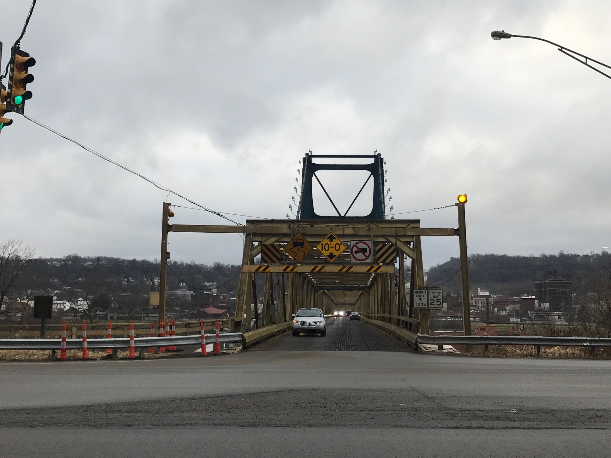
Even though State Route 2 had some traffic, I made an executive decision to try my luck on it for the way back. Despite beginning without a shoulder, it turned out to be a rather innocuous road. There was a good view of the imposing coke fabrication complex (Mountain State Carbon) followed by two bridges leading across into Steubenville, Ohio. The first was the older Market Street Bridge. It is narrow but has a sidewalk on the downstream side that can be used in the event one might need to cross the Ohio River. Plans to close the bridge have been discussed for many years but it is still open. The latest information indicates that it may close when the Wellsburg (WV) to Brilliant (OH) Bridge, lying further to the South, is completed.
By this time, Route 2 was a divided 4-lane highway that had acquired a wide shoulder. Even though there were rumble strips, seam cracks, and a fair collection of pebbles and grit, I was happy to have the space. Motorists gave me a lot of room anyway by moving over to the left travel lane nearly all of the time. The highway noise was negligible with all of the other unexpected "amenities."

| Heart | 0 | Comment | 0 | Link |
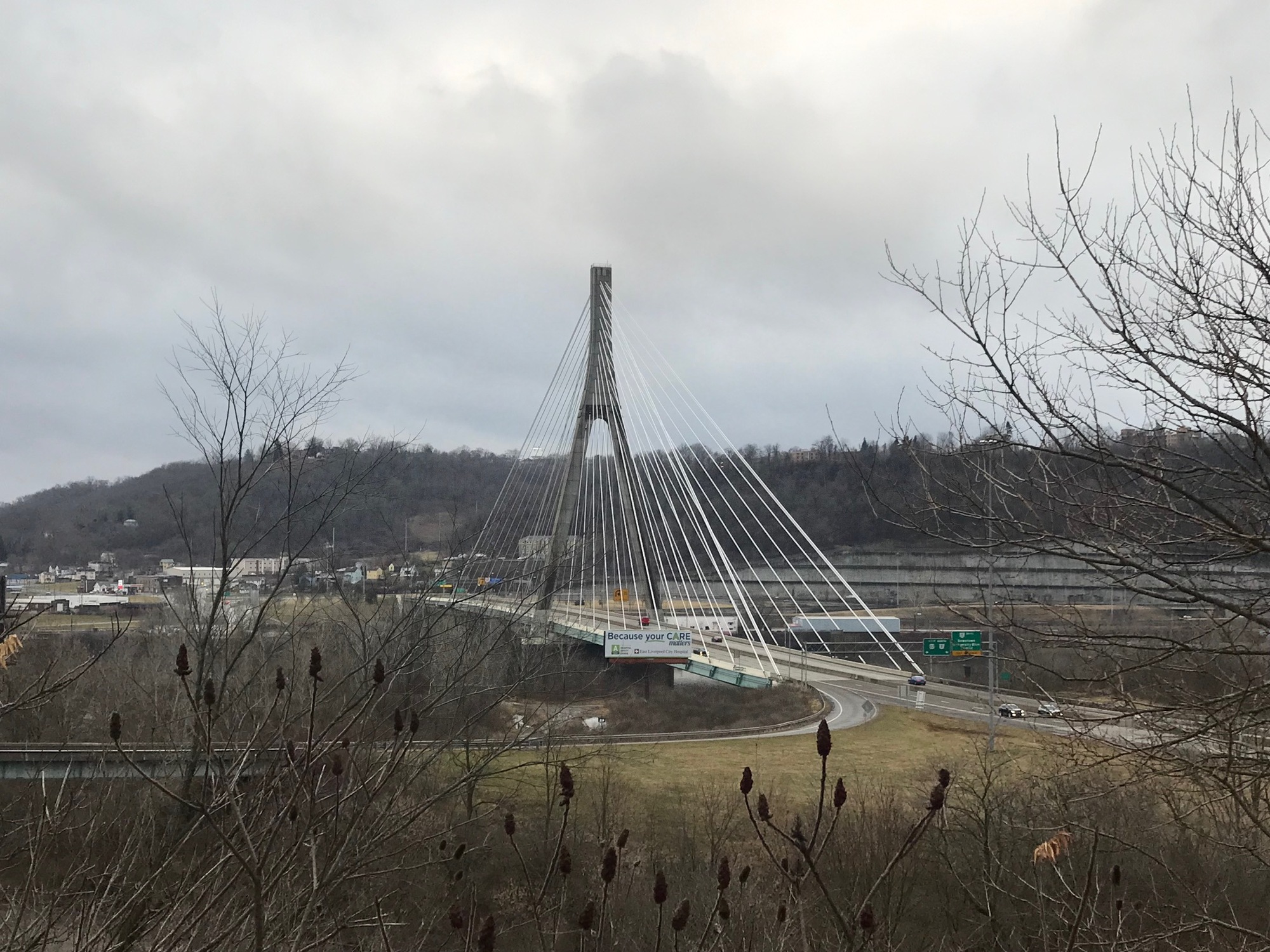
The newer Veterans Memorial Bridge that carries US-22 across the Ohio River to Steubenville came into view as I proceeded further North toward Weirton. This distinctive cable-stayed bridge catches the eye as one approaches it. I suppose it could be ridden across on a bicycle but given the choice, I'd enjoy this view and then take the bridge at Market Street.
Shortly after the turn off for the bridge to Steubenville, SR-2 drops into downtown Weirton and becomes the main drag. I followed it to Cove Road, aka Route 507, and turned right. The earliest settled part of Weirton was near here at a point where Harmon Creek emptied into the Ohio River. In 1793, it was called Hollidays Cove.
Weirton was named after E.T. Weir, who had ten steel mills operating in this valley at one point in time. Another interesting fact about Weirton is that it is the only U.S. city that sits entirely in one state while its borders touch two other states (Ohio and Pennsylvania).
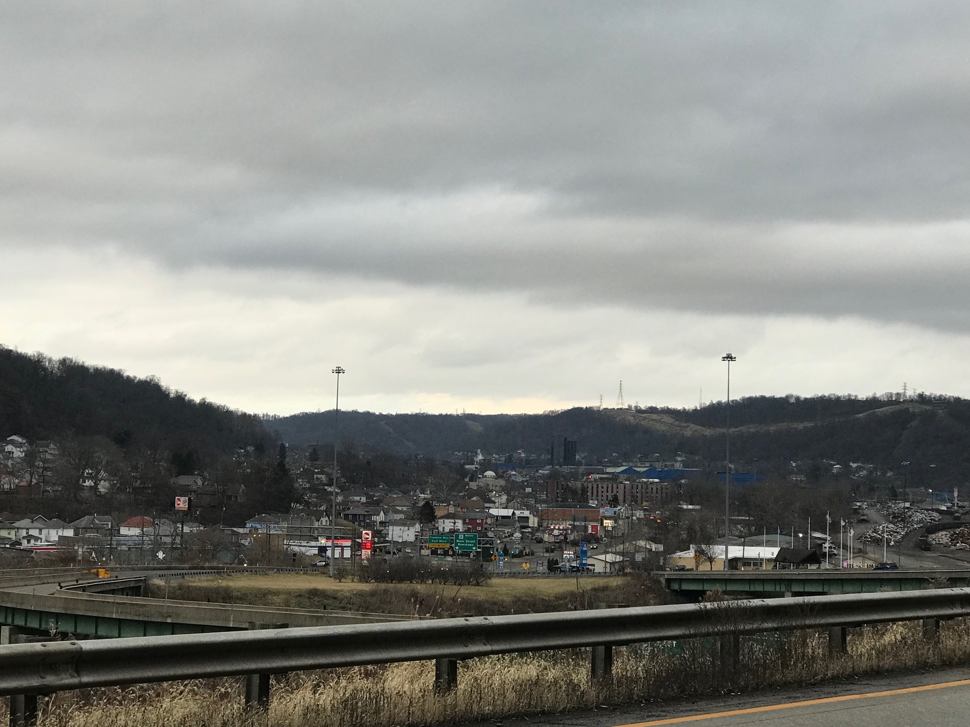
Cove Road continues to a point where it turns left as Route 507. The road ahead becomes Harmon Creek Road and leads under the Route 22 superstructure to a right onto McColl Road. A short coast leads to the trailhead and the end of this ride. We're still in the industrial Northern Panhandle of the state where the roads are gritty, especially at this time of year. Cleaning and lubing the bike and drive train afterwards is a must.
Today's ride: 21 miles (34 km)
Total: 126 miles (203 km)
| Rate this entry's writing | Heart | 1 |
| Comment on this entry | Comment | 0 |