June 19, 2023
Mason-Dixon Ramble
Meandering Along the Border
"Below Route 40 (in Pennsylvania), it's all West Virginia." (An acquaintance who shall remain anonymous).
June 19, 2023 - 44 Miles
The Mason-Dixon Line was the border between the Union North and Confederate South during the American Civil War. It divided Southwestern Pennsylvania from what was Virginia, when the war began (1861). The western counties of the Old Dominion broke away and sided with the Union. Their application for statehood was quickly ratified, establishing a Union-aligned State of West Virginia, in 1863.

| Heart | 0 | Comment | 0 | Link |
Back in colonial times, a border dispute between the Penn and Calvert families, brought about one of the most famous surveying projects in American history. In 1763, astronomer Charles Mason and surveyor Jeremiah Dixon, began the huge project of accurately establishing the border between what was at that time the colonies of Delaware, Maryland, and Pennsylvania. By 1780, they made it as far as Brown's Hill, in what is now Mason and Dixon Park, near Core, West Virginia. They were prevented from going any further by Native Americans who controlled the area at the time. It took another 14 years for the project to be completed by Anderson and Ellicott, who have been mostly forgotten by history.

| Heart | 0 | Comment | 0 | Link |
The goal for this ride was to reach the Mason and Dixon Park via rural roads and backtrack to the starting point. Doing this would lead to multiple crossings of the border, most of which were unmarked. Along the border, the two states really do seem to be the same, as evidenced by the terrain, flora, fauna, road quality, lack of signage, shared histories, lifestyles, religious beliefs, and politics.
Point Marion, Pennsylvania
The ride began in this unique little town that sits at the confluence of the Cheat and Monongahela Rivers. Both waterways flow Northward from West Virginia to meet here. The Cheat, known for its excellent whitewater, is a tributary of the Monongahela. The mighty Mon River is one of the three rivers that meet in Pittsburgh. There it joins with the Allegheny to form the Ohio River.

| Heart | 0 | Comment | 0 | Link |
Point Marion is in Pennsylvania, by virtue of the arbitrary Mason-Dixon Line, which is approximately 1.5 miles to the South. However, it sits on a projection of land coming up from West Virginia that is completely separated from the rest of Pennsylvania by the two rivers. Morgantown is closer than any Keystone State city. This unique little borough reflects aspects of both states.
Economically, Point Marion is depressed, like many other towns in the area. A glass factory that once brought prosperity to the town was shuttered and sold off a generation ago. Along with downturns in the coal and steel industries, the closing of the glass factory led to an exodus of people and businesses. The roughly 1100 who remain are trying to keep the place going. Their efforts appear to have achieved a measure of success. There are fewer abandoned and blighted properties than are observed in other area towns, the place is clean, and there is community pride.
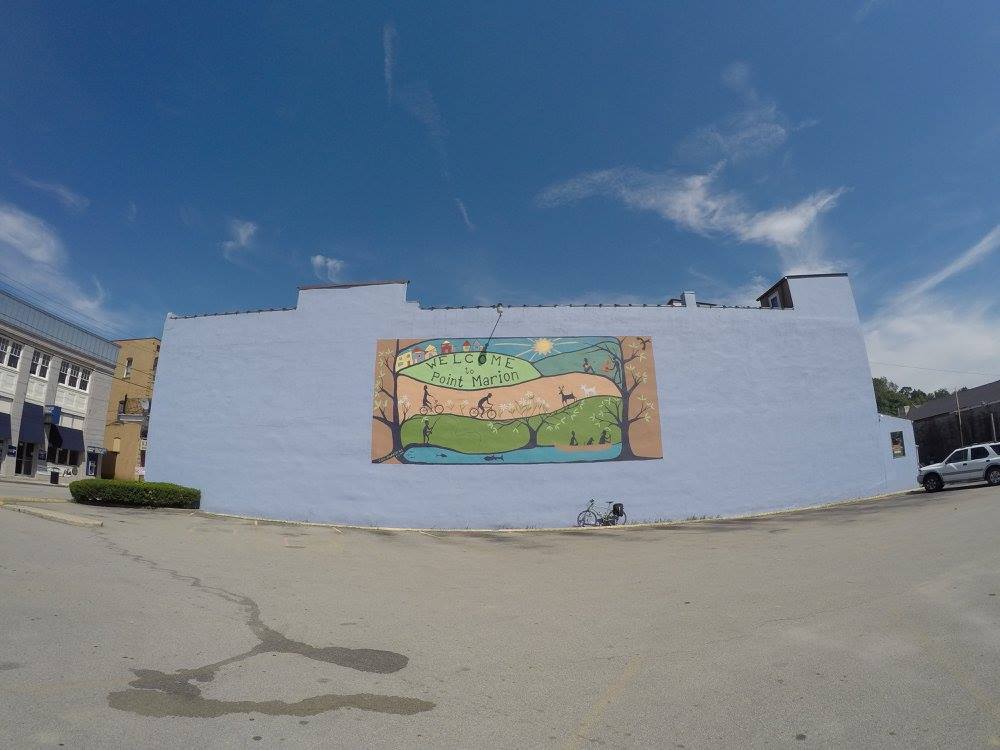
The Sheepskin Trail runs through town, to Morgantown, West Virginia, and connects with a network of trails in the Mountain State. Since I will use the trail on other stages of this tour, the Point Marion trailhead was a good spot to begin today.
Plans are for the Sheepskin Trail to eventually connect with the GAP Trail, some 35 miles to the North. When that occurs and a few smaller sections in West Virginia are joined, the roughly 200-plus mile P2P (Parkersburg to Pittsburgh) trails system will enable long distance off-road hiking and bicycling in the area. Point Marion, already a neat place, is poised to become a cool trail town and to reap the benefits from that association. Right now though, things are pretty quiet there.
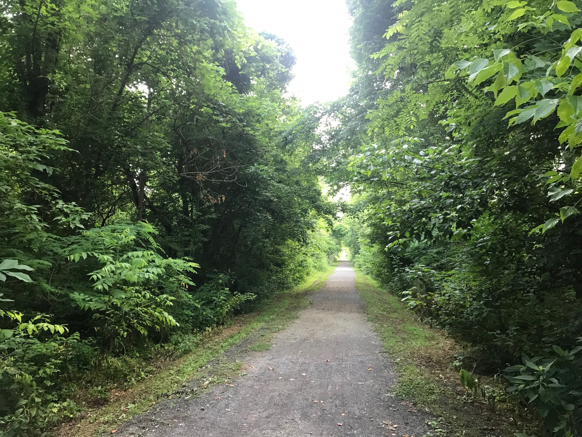
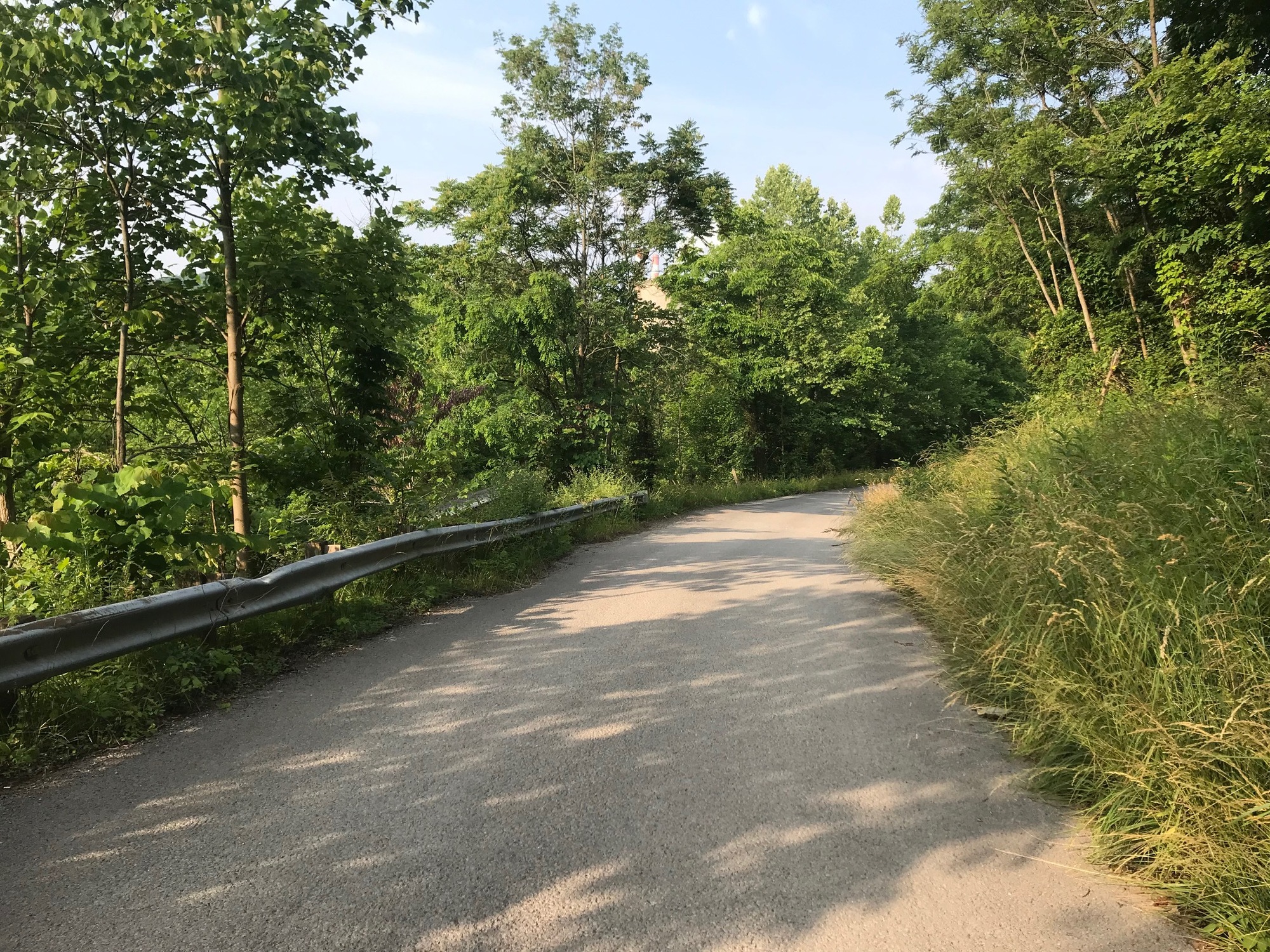
I took the trail Northward, about a mile, to where it currently ends near the center of town. From there, I headed out of town by crossing the big blue bridge, one of the few structures that connects Point Marion to the rest of Pennsylvania. Once on the other side, I made a very sharp left onto Power Plant Road, headed for Mountaineer Country.

| Heart | 0 | Comment | 0 | Link |
The Ride Along the Border
The lightly traveled Power Plant Road leads to the locks and dam complex on the Monongahela River (in PA) and further along to the Fort Martin power station (in WV). My mapping program wanted to take me onto an access road into the plant but signs forbidding entry stopped me.
An ensuing map review found an alternate route. I returned to a turn onto the gravel Crooked Run Road that had been passed earlier. Its flat and meandering course crossed the border three times, without any fanfare, before coming to a T-intersection on the state line. A right turn was Bobtown Road and Pennsylvania. I went left on Fort Martin Road, into West Virginia.

| Heart | 0 | Comment | 0 | Link |
Although traffic was light, there were some large dump trucks and tractor trailers. They all gave me plenty of room. Once again, my mapping program tried to lead me onto the restricted grounds of a private company. This time its was at the Longview Power Plant and a place called the Haul Away Company. A steady stream of large trucks were coming in and out of the property. I returned to Fort Martin Road and followed it for several miles. Doing so, I found that most of the trucks were turning into an industrial park that lay at the bottom of a big hill and alongside the Monongahela River.

| Heart | 0 | Comment | 0 | Link |
I stopped to talk with a fellow who was running a boat yard along the river. He told me the trucks were involved with various projects, some of which involved hauling coal, rocks, and construction debris. After cautioning me, he pointed out some rather long skid marks in front of his property. Apparently, a coal truck had recently hit a garbage truck that was stopped for collection. The coal truck driver's excuse was that he had to run overweight and fast in order to make any money. Good grief!
Later, on this ride, one such truck passed me even though I had attempted to signal to him that there was oncoming traffic. The situation got a lot more tense than was necessary. This kind of thing has been going on for many years. There are stories of some really bad accidents. I'm not against coal but some better enforcement is needed to discourage dangerous driving practices.
Eventually, Fort Martin Road led me to a turn onto Route 100, also known as Lazzelle Union Road (LUR). This very pleasant and peaceful road led through the very small town of Maidsville, which was not much more than a cluster of homes. From there, the relatively flat LUR wound through the countryside until it reached US-19. A right turn headed North and back into Pennsylvania. Route 19 had a narrow shoulder and some intermittent traffic but I never felt unsafe.
At the gravel Wades Run Road (WRR), the mapping program called for me to bear left. Traffic there was virtually non-existent. The gravel was of very small stone that was not bad to ride on. The road was again mostly flat and it was lined with banners honoring military veterans, several of whom had the last name of Wade. I stopped to take a photo of a patriotically decorated home, only to later realize it also had a black lantern boy statue out front. Besides such statues, one will also find Confederate flags flying along with the American variety. Be forewarned, that is part of the reality of life 'round here. I simply take the position that I am only a passing observer, documenting what I see.

| Heart | 0 | Comment | 0 | Link |
WRR leads into the small borough of Mount Morris, where there are some limited services available. One difference between the two states is that in Pennsylvania, most towns of any size are called boroughs. While in West Virginia, they seem to be called towns or villages.
I only stopped briefly in Mount Morris before continuing onward, via Big Shannon Run Road (BSRR). Since nearly all of the roads I had been on so far followed stream beds, I was enjoying very pleasant riding conditions. The trend continued as BSRR went on for several miles before turning onto Little Shannon Run Road (LSRR).

| Heart | 0 | Comment | 0 | Link |
I was seemingly in conflict with my mapping program throughout this first half of the ride. It was calling for a turn from LSRR onto Henflint Road. After turning, a steep climb with a surface of 1-1.5 inch stone awaited. A memory of having passed this way once before came to me. I recalled that Henflint Road would lead me to Ripley's Run Road, which would turn into Ripley's Run stream bed before bringing me out to the bridge over Dunkard Creek.
Since I wasn't anxious to repeat that experience today, I paused once again to check the map for an alternative route. A look at the map indicated that if I stayed on LSRR, another road would take me into West Virginia and my destination, which was Mason-Dixon Park. Whether or not it would be any different that the Henflint-Ripley's Run combination remained to be seen.
Around these parts, a "Run" is a term for a stream bed. Legend has it the early Scottish settlers used the term to name many of the mountain streams in this part of the world. The term "Run" has persisted into modern times. Today, there are a plethora of "Runs" and "Run Roads" in the area. I was on several of them today.

| Heart | 0 | Comment | 0 | Link |
A bit further along, a small bridge to the left crossed Little Shannon Run and was followed by another left onto Blacks Run Road (BRR). Here, the climbing that I had mostly avoided thus far, began in earnest. BRR wound relentlessly upward to the top of a wooded ridge. If any cars passed me, I don't remember, but it can be reported that traffic is not a problem on Blacks Run Road.

| Heart | 0 | Comment | 0 | Link |
Once I crested the ridge, it was all downhill, transitioned to gravel, and headed back into West Virginia. The gravel road crossed over Hackelbender Run, into a little community at the bottom. It then went onto a narrow bridge over Dunkard Creek, and out to West Virginia State Route 7, aka The Mason-Dixon highway and/or SR-7.

| Heart | 0 | Comment | 0 | Link |
As is common with Mountain State highways, SR-7 had minimal shoulders. It winds along Dunkard Creek and there is some high speed traffic. However, no problems were encountered. It seemed that any vehicles approaching from behind either slowed down until it was safe to pass and/or when passing, gave me wide berths. Save for the infrequent rogue coal truck driver, West Virginia motorists seem to be more cautious and courteous than their Keystone State counterparts.

| Heart | 0 | Comment | 0 | Link |
I followed Route 7 for a couple of miles to a left onto Buckeye Road. The Dunkard Creek Bridge is a landmark that is visible from the intersection, confirming the correct way to proceed. Beyond the bridge is Mason and Dixon Park with a street address in the town of Core, West Virginia. Like other small towns in the area, Core is unincorporated and not very big.

| Heart | 0 | Comment | 0 | Link |
The park is clean and very well maintained by a fellow who lives adjacent to it. The man I talked with back at the boat yard gave him high praise. All kinds of events are held here, including dinners, music performances, and the usual cookouts and campouts. There is a ramps dinner held in the Spring that I want to get to one day. Ramps are wild edible onions that come in the early Spring and are ready for consumption by the end of April. I've had them before and they are excellent. But to get the full experience under my belt, I have to get to the source. Perhaps next April, the stars will align.
The return trip to Point Marion was by a different route that began on Buckeye Road. I wanted to avoid the truck traffic on the way back because a big hill on a narrow road with big trucks is not a good combination for a cyclist. This would occur near the Fort Martin Industrial Park that was mentioned earlier. On the way here, I was going downhill and was able to stay in front of the trucks. But that would not be possible while climbing that steep hill on the way back. As a result, most of the return trip was close to the Mason-Dixon Line, but in Pennsylvania. Since the areas on either side of the line are very similar, the tone of the ride remained the same.

| Heart | 0 | Comment | 0 | Link |

| Heart | 0 | Comment | 0 | Link |

| Heart | 0 | Comment | 0 | Link |
I rolled back into Point Marion during the early afternoon. Not much was happening on this Juneteenth Holiday. For all I know, it may be like that everyday. With only a few cars moving along, a couple of pedestrians walking by, it was pretty quiet in town.

| Heart | 0 | Comment | 0 | Link |
The deserted Brass Rail Bar was open for business, so I walked inside. It was dark and smokey, but not a single soul was there to be found, so I left. Later on, I read some advice from Anthony Bourdain, recommending that you should make it a point to have a pint in a deserted pub somewhere and strike up a conversation with someone who is from a completely different background than yours. The Brass rail in Point Marion is such a place to have that experience. Next time...
Today's ride: 44 miles (71 km)
Total: 285 miles (459 km)
| Rate this entry's writing | Heart | 1 |
| Comment on this entry | Comment | 0 |