April 20, 2024
Berkeley Springs to Paw Paw
The Eastern Panhandle - Morgan County
Thus far, these cycling jam sessions in the Mountain State have been confined to the Northern Panhandle and Northern counties near the border with Pennsylvania. A recent family event took me East, close enough for a visit to the healing waters in the resort town of Berkeley Springs and a subsequent exploratory bike ride in the area.
First, a little background. West Virginia is "the only US state with two panhandles."
Update: Texas is considered by some to have two panhandles, Northern and Western.
The Northern panhandle of West Virginia was discussed in some earlier chapters of this journal.
Depending upon what source one might consult, the Eastern Panhandle (EP) has 8 counties: Jefferson, Berkeley, Morgan, Hampshire, Mineral, Hardy, Grant, and Pendleton. The last one, Pendleton, is disputed by some, as being part of the panhandle. A look at the map makes the case for inclusion. Although attached to the main body of the state, Pendleton County seems to "flow" South from and be in line with the rest of the EP.

| Heart | 0 | Comment | 0 | Link |
The ride for today was entirely within Morgan County, of which Berkeley Springs is the seat. Formerly called Bath, the town was renamed when it became part of the state of Virginia. As was mentioned in an earlier chapter, the Western Counties (including those in the EP) of Virginia split off from the Old Dominion when the civil war broke out. They applied for statehood and the petition was ratified in 1863. West Virginia became a state and sided with the Union during the civil war.
I've been to Berkeley Springs on several occasions. Like the Native Americans, who went there for thousands of years, and later the European settlers, we tourists go now for the same reasons, to bathe in the warm(er) and healing mineral spring waters that flow from underground. At the source in town, is a state park with facilities featuring Roman Baths, saunas, massages, and various spa treatments (which my wife enjoys). A few photos from two recent visits (with dates) are presented below.
In town there are several restaurants, shopping boutiques, and lodging sites. Notable are the Country Inn and its restaurant, the Morgan Tavern. A couple of other good spots are the Cacapon Mountain Brewing Company, and The Naked Olive. Several Bed and Breakfasts do a brisk trade and there is a Best Western Hotel about 1.5 miles South of town on US-522.
The Morgan County Courthouse and Public Service Building is an impressive structure in the center of town and along the main drag (US-522). The Trail Depot is a good bicycle shop and wilderness outfitting store that is in town, a bit North of the center. Lying about 8 miles South of the Chesapeake and Ohio Canal and Towpath (C&O), as it passes through Hancock, Maryland, Berkeley Springs is positioned well enough to take advantage of that magnificent National Park and its amenities.
There is an old abandoned rail line that runs from town to the river. When completed, it would provide a good trail link to the C&O. Currently, there is still a lot of work needed to make that a reality but there is a lightly traveled backroad (Fairview Road, aka County Route 2, to River Road to US-522) from town that could be used, with relatively good safety, to get to the C&O.

| Heart | 0 | Comment | 0 | Link |

| Heart | 0 | Comment | 0 | Link |

| Heart | 0 | Comment | 0 | Link |

| Heart | 0 | Comment | 0 | Link |

| Heart | 0 | Comment | 0 | Link |

| Heart | 0 | Comment | 0 | Link |
After a relaxing afternoon and evening on the 19th, the morning of the 20th dawned clear and cool, making for a great day to ride. From our lodging spot, I headed North on US-522 toward the intersection with West Virginia State Highway 9 (SR-9) that I would be following for the lions' share of this ride. According to Wikipedia and from what I can see on the various maps, SR-9 is the only state road that stays entirely within the EP to connect it with the rest of the state. When using any of the other roads, state line must be crossed. In later versions of this journal, we will be doing that.

| Heart | 0 | Comment | 0 | Link |
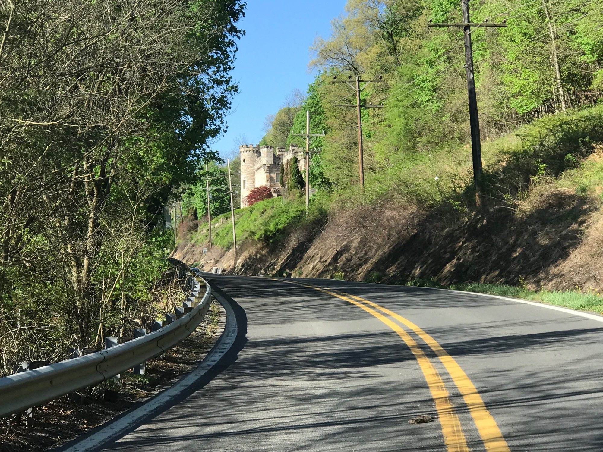
In the middle of town are intersections with SR-9, the first heading East and the 2nd West. Leaving town on SR-9 West means an immediate serious climb. Berkeley Springs sits in a valley with big Appalachian Ridges on either side of it. On this day, the new green leaves provided some color and were beautifully offset by the lavender-pink blossoms of the Eastern Redbud trees. On the way up is the Berkeley Castle. It was built around 1885. Because it is on private land and the road is very narrow, it was difficult to get a good photo but I did snap a pretty good one during a brief break in the traffic.
| Heart | 0 | Comment | 0 | Link |

| Heart | 0 | Comment | 0 | Link |
SR-9 rose and fell a couple of times before reaching a beautiful point that overlooks the Cacapon River Valley. Although the road and its shoulders were narrow, traffic was light and motorists were courteous. I was surprised at the very good level of comfort that I felt being out there. The view at the overlook was tremendous and there is a restaurant across the road from it. Although not open at this early hour, I'll bet it would be a nice place to enjoy a meal and a beverage.

| Heart | 0 | Comment | 0 | Link |
From the overlook, SR-9 descends and winds around a few curves on its way to the unincorporated village of Grand Cacapon. Despite its name, the village appears rather ordinary and has a few rundown properties within its borders. On this beautiful Saturday morning, not many people were around or out in their yards... still enjoying some rest or their morning coffee, I suppose. I continued on through and for several more miles to my turn onto Detour Road.

| Heart | 0 | Comment | 0 | Link |

| Heart | 0 | Comment | 0 | Link |
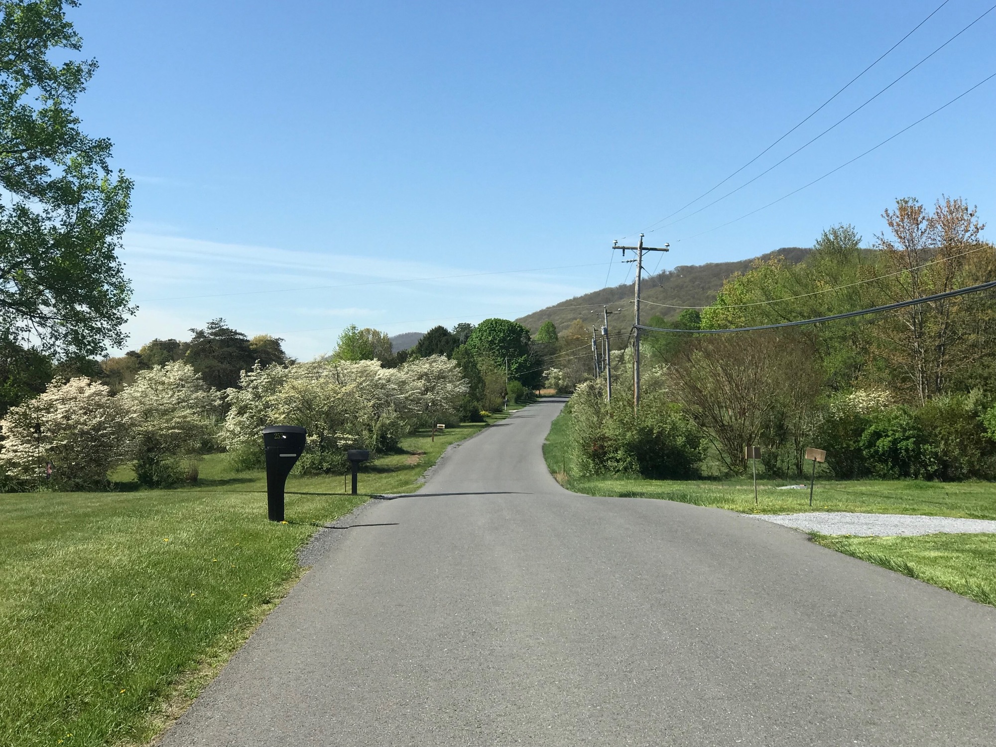
On the map, Detour Road appeared to be a bit of a shortcut and quiet enough to also act as a respite from the narrow and more heavily traveled SR-9. In retrospect, the choice is a wash because Detour Road is extremely hilly and the traffic on SR-9 is not all that bad. But I'm getting ahead of the story. I took the right turn onto Detour Road and immediately started a long climb, gradual at first and then becoming steeper. Once on top, there were a few homes and quite a number of flowering White Dogwood trees in full bloom. The unexpected scene was quite picturesque.
The road meandered on for a bit and then a 2nd climb began. Believe it or not, this one was longer and steeper than the first. I say that because after finishing the first climb, the road did not seem to descend enough to allow for another one, such as I was toiling with now. Luckily for granny gears, which I used and patiently spun my cranks, incrementally ascending this rather steep slope. At the top, I was rewarded with another tremendous view. For this one, I leaned my bike against a mailbox "pole" and snapped a photo. Nobody seemed to be around or to mind me being there. It was very quiet and the vista was magnificent.

| Heart | 1 | Comment | 0 | Link |
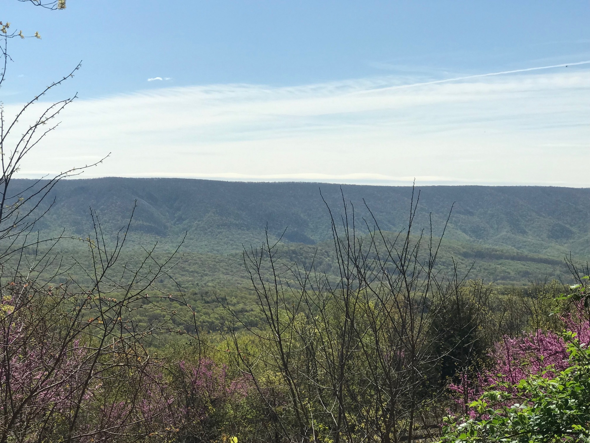
When I turned onto Detour Road, I was following a stream bed and was at the lowest elevation on the route, 463 feet above sea level. The first climb got me up to close to 900 feet elevation and followed a plateau, of sorts, for a bit. There was a brief steep drop before the 2nd climb began. It took me up to the highest elevation on the route, which was in the neighborhood of 1600 feet. On the way up, a young fellow in a dune buggy came by from the other direction and gave me a friendly wave. I would see him again before this ride was finished.
While on top of the 2nd summit area, a few houses sported various tributes to the General Lee, an orange sports car made famous by the old television show, The Dukes of Hazzard. I didn't get any photos of the car replicas but one place had an old sign that might have come from the area of Kentucky, where the fictional show was based.

| Heart | 0 | Comment | 0 | Link |
Eventually, the terrain began to drop, precipitously at times. After a long downhill, I reached a T-intersection with Magnolia Road #18 going left and Magnolia Road #12 heading to the right. My planned route called for a right turn but it would eventually involve a gravel road near the river. With all of the recent rains and flooding, that gravel road could be a bad choice. As I was deliberating, my buddy in the dune buggy arrived and stopped at the intersection. He confirmed that the gravel road is very muddy at this time and recommended that I go left onto #18, which would eventually meet SR-9. He estimated it was 4 miles to that point but then 2nd guessed himself. It turned out that his initial estimate was on target.
Initially, it appeared that I would need to re-climb Sideling Hill. Although I was resigned to my fate, the prospect wasn't very palatable. However, after a little bit of garden variety ascending, I found myself to be on a mostly gradual downhill path. The road was rough in spots but I took it on carefully so as not to hit an irregularity and potentially take a spill.

| Heart | 0 | Comment | 0 | Link |
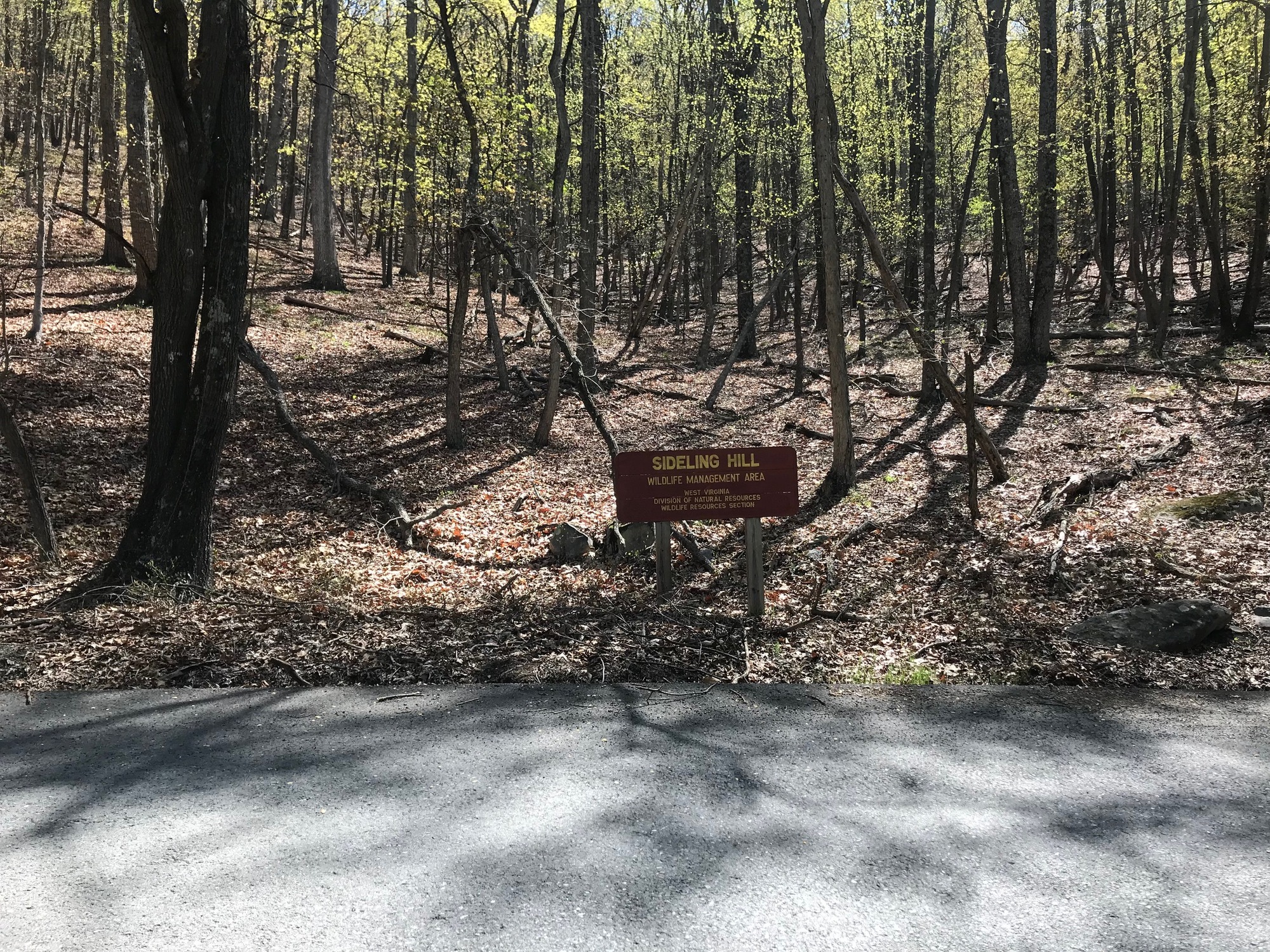
Further along, on the way further down , I saw a sign denoting that I was in the Sideling Hill Wildlife Management Area. As I stopped for a photo, a large Red Tail Hawk flew right over my head and into the woods. It was gone before I could get the camera ready but I did get a shot of the sign. Sideling Hill is a long and rather high Appalachian Ridge that runs from near this point up into Pennsylvania. In Maryland, along I-68, there is a Sideling Hill exhibit and visitor center that is worth checking out. From Wikipedia, "Sideling Hill is a syncline mountain, in a region of downward-folded (synclinal) rock strata between two upward-folded anticlines." Here where I was on this ride, it was heavily wooded and the rock strata were not exposed.
The road had its share of very tight curves that were the rationale for a sign I had seen at its beginning, warning that the road was not suitable for tractor trailers. From one of the curves, I could see a patch of beautiful deep purple flowers below. They were a Grape Hyacinths lying in the grass along a stream bed. I had to stop and try to capture the scene, as best I could. Fortunately, there was no traffic.

| Heart | 1 | Comment | 0 | Link |
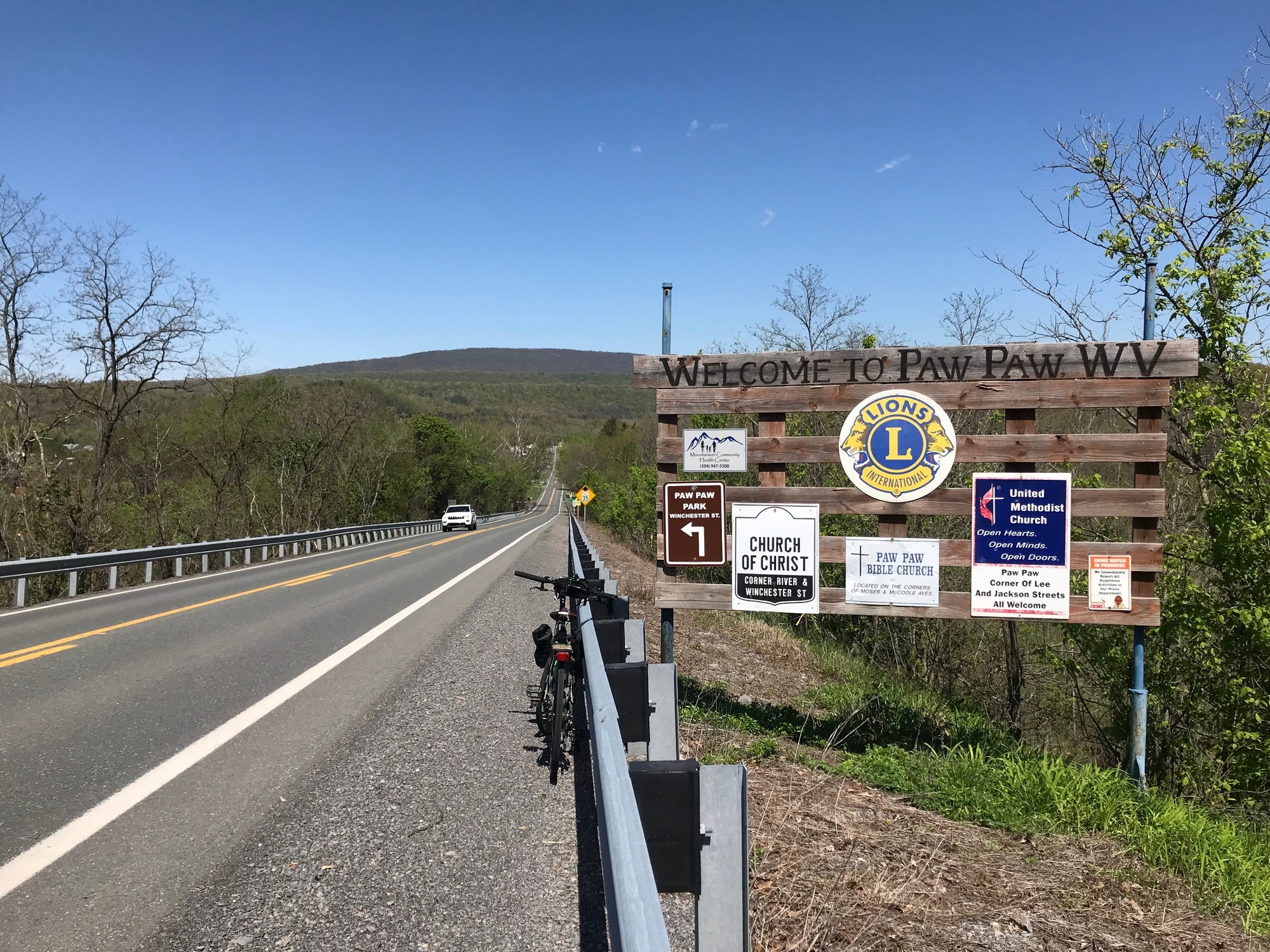
Eventually, Magnolia Road #18 met SR-9 and I turned right toward the town of Paw Paw. Named for the Paw Paw Tree and its fruit of the same name, the town is known among cyclists and hikers for its proximity to the C&O Canal and Towpath, on the other side of the Potomac and in Maryland.
Also on the C&O is a long tunnel called the Paw Paw. When open, the tunnel is an engineering marvel and a unique experience to ride or walk through. Sometimes, the tunnel is closed for renovations and repairs and then trekkers have to go up and over the mountain to rejoin the C&O. Doing so, reminds us of what the terrain is really like around here... very hilly and challenging.

| Heart | 0 | Comment | 0 | Link |
Back in 2016, one of our adventures involved riding in mid-September on the C&O near Williamsport, Maryland. It happened to be ripening time for the Paw Paw fruit. At a brief break stop, falling Paw Paw fruit were hitting the ground constantly and all around us. I gathered a couple dozen of them, filled a pannier, and later made a dessert for the group that evening. That was a satisfying and really cool bit of serendipity.

| Heart | 0 | Comment | 0 | Link |
On this ride, the goal was to reach the town of Paw Paw, West Virginia where the ride would finish. Since my wife was patiently waiting for me there, I dared not dawdle too much more than I already had. Fortunately, she understands and appreciates my obsession and gives me a lot of latitude to pursue these kinds of adventures.
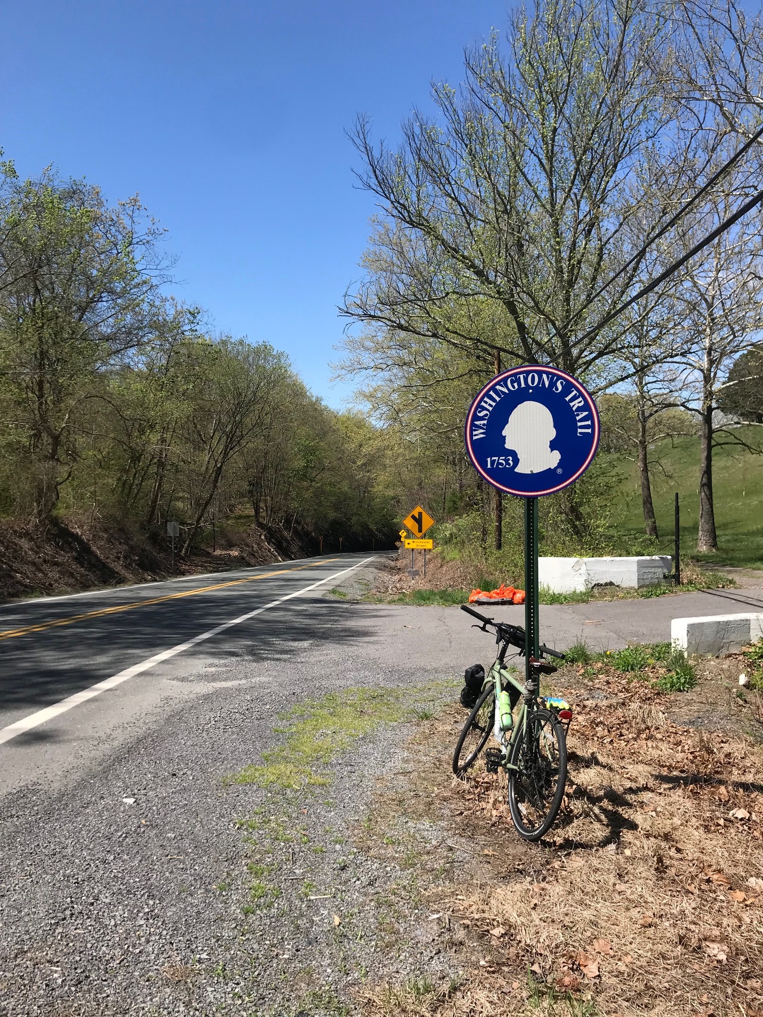
To finish up today, I rode on SR-9 for about 2 more miles. There was one climb that was not very difficult, especially after the several I had already done to get to this point. A sign indicated this was a route taken by George Washington in 1753. No doubt, after one of those Roman Baths, he was looking for some Paw Paws, a cold beer, and a place to sleep. There are signs all over this area indicating that ol' GW slept here and there. I'm not asking anymore questions.
I reached Paw Paw unscathed and happy to have completed another segment of this Mountain State tour. It was beautiful, clear, if not a little cool, and a great day for a ride. At the corner of Winchester and Lee, there is a Liberty Gas Station with an amply stocked convenience store. There is at least one lodging establishment and the Mountain Life Kitchen, if you need a sit down meal. Perhaps on the next trip through, I'll check those out and report further. Until then...
Today's ride: 23 miles (37 km)
Total: 417 miles (671 km)
| Rate this entry's writing | Heart | 2 |
| Comment on this entry | Comment | 0 |