June 17, 2023
Day 45 - June 17 - Fort Collins, CO to Mountain Park Campground, CO
Hallelujah!
Ed’s story
This journal entry is for Saturday, June 17th but is being published on 6/19 due to no cell service.
This is the day we’ve been waiting for. We’re going to start climbing the Rocky Mountains. Started moving and got up around 5:30. It was tough after two full days of sleeping in.
Finished packing the bags and ate breakfast. I ate my leftovers from the night before; with an orange and some coffee. I had to seriously reheat the leftovers: the refrigerator had frozen them.
Loaded the bikes, then did one final check of the room, and took off. I can definitely feel all the extra weight on the bike. This was not only the food stuff we bought, but the cooler weather gear I had shipped ahead from Wheeling, West Virginia.
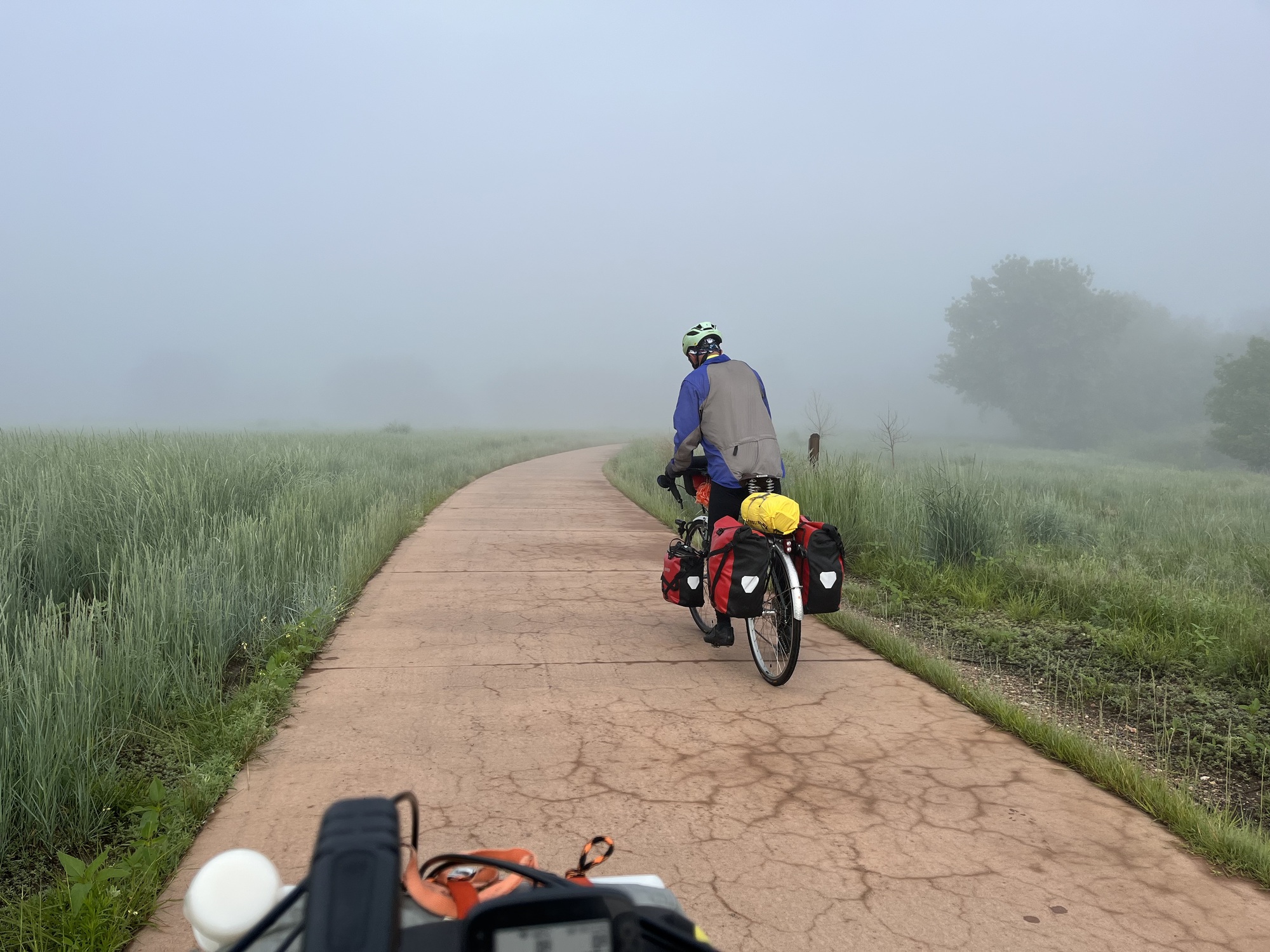
It was pretty foggy when we left. I had both lights flashing, hoping to be seen. Even my glasses started getting all wet from the fog. My fingers turned into windshield wipers.
| Heart | 9 | Comment | 0 | Link |
Shortly after we left the hotel, we joined the bike trail in Fort Collins. We meandered about, crossing the river in several locations getting a good view of the rushing water. All the rain we had the last two days had really swollen the river. I would not have wanted to fall in.

We came to two locations where the trail went under a bridge next to the river. The trail was flooded in both of those locations. We backtracked, crossed the road to the other side, and continued on the trail.

We came across various bikers and walkers along the trail. Even though it was cool and damp, some of them only had on shorts and either a T-shirt or a long sleeve top. I would have been too cold dressed like that.
At about the 8 mile point we came across another flooded section with several people checking out the flooded area. It turns out they were some of the organizers for a ride going on in the area. We happened upon the rest stop for an organized ride going on in Fort Collins. The goal of the ride was to collect money and raise awareness to fight human trafficking. I believe it was called Freedom Ride. They allowed us to enjoy the snacks and beverages at the stop.
We rode about two more miles, left the Fort Collins Trail, and joined a local county bike trail. We took this for about three more miles before the trail disappeared and we rejoined the highway.
As we traveled across Kansas, Nebraska, and Colorado east of Fort Collins, the land was pretty open spaced and desolate. Various riders we came across in these areas told us that the scenery changed significantly west of Fort Collins. Boy were they correct. It has some really beautiful country here as you get into the mountains.


Shortly after rejoining the road, we took a rest stop at a convenience store. I bought three orange juices: one to drink and two to carry for the next two days. Actually I bought one for $2.49 and drank it. Then I bought the other two: they were $4.00. I guess buying in bulk helps.
About a mile or two after leaving the convenience store, we started climbing and shortly thereafter exceeded 1 mile in elevation. Another milestone: 5280 feet. And we just kept on climbing.

There are numerous rest stops, picnic areas, and camping areas on Colorado Highway 14 heading up toward Cameron Pass. We stopped at several of them just to give our legs a break, as we were just constantly pedaling to increase elevation.

| Heart | 7 | Comment | 0 | Link |


The elevation profile on the GPS is not always accurate. It must be looking at the landscape in the vicinity of the road. There were several locations where it indicated the grade was at least 8% or more. It never got above 3 - 4 % in those locations
When we were about 3 miles from the Mountain Park campsite (where we hoped to stay for the night ) John disappeared. I passed a smaller campground, and even though I looked in, I did not see either John’s yellow jacket or his red flashing taillight. I assumed he just went on.
I rode half a mile and stopped and waited just in case he was behind me. I did this three times until I was about a mile and a half from the campground I passed.
I pulled to the side of the road to take a nature break and wait a little bit longer. As I was standing by the road, a pickup truck slowed and the driver asked if I knew where a certain campground was. I said no, but asked him if he saw another touring cyclist. He said yes, he was about a mile behind me. John eventually showed up.
He said he went into the campsite and went behind a sign and underneath a cover to change into his rain pants. (We already had jackets on due to the light rain that had started.) He kept waiting for me to pull in and then decided to head out figuring I was ahead of him.
Two miles later we made the turn into the Mountain Park campground, and lo and behold there is a sign that says Sites Available. We were overjoyed, because nothing showed up on the campsite webpage showing site availability.
We found the camp host, and were actually able to get a site with electricity. It is a short walk not only to the shower house, but to the vault toilets in the bathrooms.

Set up the tents and took a shower. The shower cost $.50; provided plenty of hot water; and even continued flowing when I was done. I understand it ran for four minutes - my training and taking a submarine shower comes in handy in the situation when you want to conserve water.
I had lunch and took a walk. Someone was very creative with the rock painting. I found several more rocks that have been painted with white flowers. Maybe it was Hansel and Gretel trying to find their way back home using painted rocks as their guide.

| Heart | 4 | Comment | 1 | Link |
https://www.inaturalist.org/taxa/48367-Penstemon
10 months ago


When I got back to camp, I decided I needed a nap since it was still early in the day. I may have drifted off for a while however; the sun was shining on the tent and it was warm inside.
This journal entry is being written at the campground, but most likely won’t be published until we get to Walden, Colorado after crossing Cameron Pass. There is no web service here.
The camp host has a satellite dish on their trailer so they can access the Internet. They did not offer to share the Internet. They have been full time RV’ers for about a year. They decided to take a job as a camp host just to settle down for a bit over the summer.
It’s probably not a bad gig, checking people in and out, but you have to make several sweeps of the campsite during the day, and you have to clean the bathrooms and showers. That would be my turn off.
Overall, today’s ride was not as bad as I had imagined. Even some of the climbs were not as steep as the Wahoo GPS indicated as I previously mentioned.
Tomorrow when we head out it will be Sunday the 18th. It is my grandson Jaxten’s 12th birthday. I called and wished him a happy birthday on Friday knowing there would be no cell service here.
Dinner was a meal of Pad Thai that I bought at REI in Fort Collins. As I was preparing it, Joe, the nearby camper came over and offered us ribs for dinner. I told him I didn’t eat meat, but my brother John would love it. He later offered us a Shiner peach beer. It tasted really good. We never turn down a free beer anymore.


Tomorrow’s ride is only 30 miles but we climb almost 3,000 feet, with an overall elevation gain of 2,000 feet. We were supposed to stay at Chambers Lake campground tomorrow. When we checked in, however, the camp host told us Chambers Lake is not opened for business yet. We will most likely stay at the Aspen Glen campground. It is 27 miles from here with a little bit less climbing than if we went all the way to Chambers Lake.
Tomorrow’s ride will take us within 10 miles of the western Continental Divide.
Regardless of when we post this journal, happy biking!
John’s Story
We woke up to dense fog and 48 degrees this morning. It was so foggy that as we rode along water was dripping from my helmet and my outer layer of clothing was getting wet. About a mile from the motel we rode onto a long paved bike path that took us all the way through Fort Collins and beyond.

| Heart | 5 | Comment | 0 | Link |
At the rest stop Ed talked about I chatted with one of the riders. She and her husband are WarmShowers hosts in Fort Collins. They have only had bicycle tourers stop at their home three times in all the years they have been hosts. When I told her we were headed up the canyon to cross Cameron Pass to Walden, she frowned and told me local cyclists don’t go that way. Traffic. No shoulders. Locals ride Trailridge Road through Rocky Mountain National Park, the highest paved road in the United States. She was surprised to hear that our route was the newest route on the Adventure Cycling map. I told her that the locals probably don’t cross Illinois on US 40, but we had done that. I thanked her for the information and went on my way. It did cause me a bit of concern though.
After 15 miles or so we arrived at Ted’s Place, more a convenience store location than a town. It is where US 287 parts ways with Colorado 14, and good riddance to that traffic. We stopped for a bio break and an orange juice. Shortly afterwards we entered the canyon proper and the climbing began.

| Heart | 4 | Comment | 0 | Link |

| Heart | 3 | Comment | 0 | Link |
The traffic in the canyon was not as bad as the woman at the rest stop made it sound. There is an occasional shoulder, the road is wide and the traffic was courteous. Many vehicles which passed us were carrying rafts for running the whitewater in the canyon. We sometimes saw them pulled over at turnouts waiting to collect their customers coming down the river.

| Heart | 4 | Comment | 0 | Link |

| Heart | 4 | Comment | 2 | Link |
10 months ago
There is a direct correlation between the turbulence and the noisiness of the river and the grade of the hill next to it. The faster and more churned up the river, the steeper the hill. A highway sign warning of sharp curves and steep grades the next three miles heralded a very frothy section of river. Luckily the grades were really not all that steep on the bicycle and not as steep as promised by the Wahoo when it announced CLIMB! for the next 1.6 miles. I think the digital topographic database used by Ride With GPS to predict climbing is confused when the surface of the land next to the road is vertical or semi-vertical.
The rock in this canyon has been folded, faulted and squeezed over countless tens and hundreds of millions of years, or more. The geologist in me would really like to spend some more time taking a closer look at these rocks, but there’s no time for that. I’m recalling a quote from hundreds of years ago describing geologists (and I’m paraphrasing here) as so many men running up and down the hills whacking the chucky stones with their hammers like so many road builders gone daft.

| Heart | 6 | Comment | 0 | Link |
Managing comfort level as I rode today was a neverending chore. I started the day with bike shorts and tights, short sleeve and long sleeve jerseys, a windbreaker and fingered gloves. As the fog burned off and the temperature warmed up I made several changes. First I peeled off the windbreaker and long sleeve jersey so I could remove the short sleeve jersey underneath. Then the windbreaker came off and the short sleeve jersey went over the long sleeve jersey. Then the fingered gloves were replaced by fingerless gloves. Then the short sleeve jersey came off. Then the threatening clouds to our south that I was not concerned about opened up and started raining lightly on us. The long sleeve jersey was replaced by the short sleeve jersey and the rain jacket went on. It started raining harder. I pulled into a campground entrance, pulled off the tights and replaced them with rain pants. On went the shoe covers. Soon thereafter the rain stopped (of course), but that was my outfit to the end of today’s ride.
There were dark clouds south of us. We’re going west (for the most part). No worries, right? Then it started raining.
With all of the to-ing and fro-ing and starting and stopping to adjust the wardrobe, Ed and I got separated. I waited quite a while after togging out in my rain gear for him to pull in behind me. He didn’t. He did not see me turn into the campground entrance to change and thought I was still ahead of him. I finally decided that, with only about 5 miles to go to our campground for the evening, I would proceed there and wait for him at the entrance road. After a couple of miles I found him waiting for me on the roadside. He had asked a motorist who stopped there if he had seen another bike tourer, and was told I was a mile behind him. I will make sure next time I pull off the road ahead of him to send up a flare. We rejoined and continued to Mountain Park Campground.
Now for a few flower pictures.


| Heart | 3 | Comment | 1 | Link |
https://commons.wikimedia.org/wiki/Lotus_corniculatus
10 months ago

| Heart | 2 | Comment | 1 | Link |
http://www.swcoloradowildflowers.com/Yellow%20Enlarged%20Photo%20Pages/erysimum%20capitatum.htm
10 months ago
And an attractive evergreen.

| Heart | 1 | Comment | 1 | Link |
http://www.swcoloradowildflowers.com/Tree%20Enlarged%20Photo%20Pages/pinus%20ponderosa.htm
10 months ago


| Heart | 3 | Comment | 0 | Link |

| Heart | 5 | Comment | 0 | Link |
Yesterday we went grocery shopping to secure enough food to last for three days, to get us from Fort Collins to Walden. At about 10:30 AM we passed a restaurant called the Mishawaka. Ed suggested we might want to eat an early lunch. I said heck no, I want to start eating what I bought to start getting the weight I’m carrying down. Then this evening just as I was about to cook one of the freeze dried meals I bought, one of our neighboring campers offered us some ribs he had smoked. Of course twigs and seeds Ed declined, but I said sure. So I never cooked that meal, and I’ll be carrying that weight tomorrow. I guess I don’t take my own advice.

| Heart | 2 | Comment | 3 | Link |
I've gone over a few rough wooden decks and wondered if it's possible for bicycle tires to get a flat from splinters.
10 months ago
10 months ago
10 months ago

| Heart | 3 | Comment | 0 | Link |

| Heart | 2 | Comment | 1 | Link |
https://en.wikipedia.org/wiki/Golden-mantled_ground_squirrel
10 months ago

| Heart | 2 | Comment | 1 | Link |
https://www.inaturalist.org/guide_taxa/262422
10 months ago

Our plan was to stay at Chambers Lake Campground tomorrow, but the host here tells us it’s not open yet. We knew there was a chance of that, but we had hopes. Instead we will stay at Aspen Glen Campground three miles closer to us. That will add three miles to the push over the pass on Monday, but perhaps we should look at it as a three-mile warmup before the big game.
We both feel we could have ridden farther today, but our strategy to break the trip from Fort Collins to Walden into three days from two is to allow us a bit more acclimatization to the altitude. We both live within in a few hundred feet of sea level. Even though we’ve been slowly climbing since we crossed the Mississippi River, there’s a big difference between 5,000’ and 10,000’. Tonight we’re close to 6,700’. At Aspen Glen we’ll be at 8,700’. Cameron Pass is about 10,300’. Walden is at 8,100’.
Tomorrow’s a big day.
Today's ride: 39 miles (63 km)
Total: 1,862 miles (2,997 km)
| Rate this entry's writing | Heart | 4 |
| Comment on this entry | Comment | 1 |
Our tech gadgets can basically have three ways to guesstimate elevation - map data, barometric pressure or GPS signal. All have their problems.
With map data, the navigator uses the GPS position signal to look up the elevation from the map. But in many cases, like if you're in a road cutting, this will not be based on the current road surface but on where the surface was before the cutting was made. These can obviously be very different.
Barometric pressure needs to be recalibrated as the weather changes, which can often happen during the course of the day.
GPS signal elevation readouts are notoriously inaccurate. The satellites' orbits are quite low, so the angles are poor for z reading.
Add to this that when you're in canyons, the x/y position can be thrown off by a lot because the direct line to some of the satellites gets obscured and your receiver picks up a signal that has bounced off the rock wall on your side, and this makes it look like you're actually riding inside the cliff face. So what's the elevation of that?
10 months ago