9) (NOT) Going home (?) v2
This time for real.
April 18
We finally scored a pair of airline tickets - Coyhaique to Vancouver. We leave from the nearest airport at Balmaceda on May 1. We will arrive in Vancouver, some 40+ hours later. It should be an interesting, if tedious, journey - flying in a time of pestilence. Blogging will continue, since we should have wifi during our numerous and very long lay-overs.
We have lots of free time until then. However there are still a few details to work out, such as transporting the bikes to Balmaceda (60 km) and figuring out LATAM's complex and expensive baggage policies.
More news as and when it happens ...
April 19
Raining hard again today. More and more shops are opening, but still no bars or restaurants. I suppose if one has to be stuck somewhere, Coyhaique is as good a place as any.

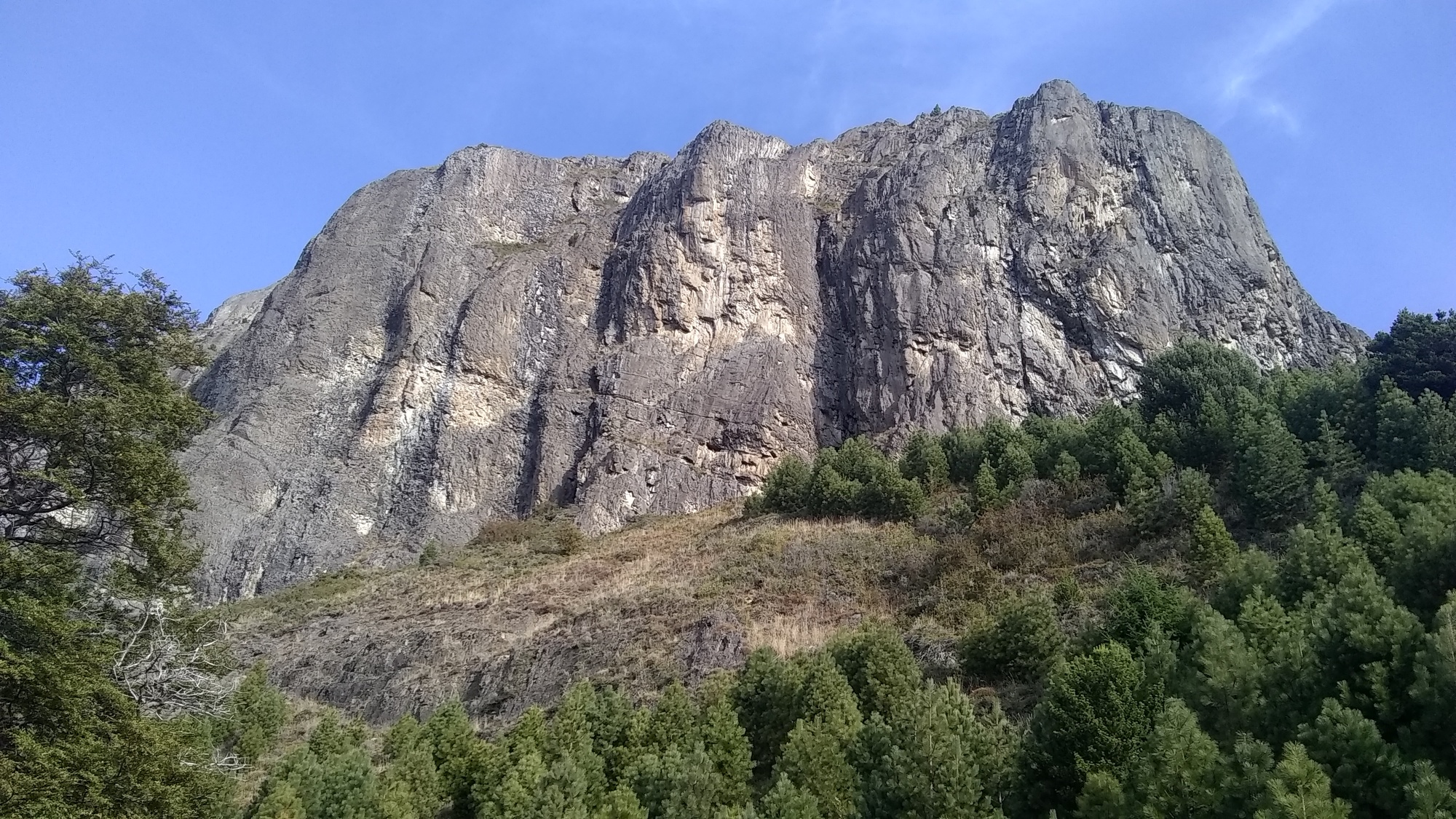
Coyhaique is a strange town. It is surrounded by attractive mountains, but it fails to take advantage of them. For example, Cerro Mackay is a small but iconic mountain only about 3 km from downtown. It would offer tremendous views from its summit. And it has a dramatic 1000 ft basalt face.

But is almost never hiked or climbed because the government sold all the land at the base of it to ranchers. Ranchers of course have no interest in allowing people to walk across their fields. So to access the mountain, it is necessary to sneak across pastures, climb fences, and defend against multiple packs of very large and aggressive dogs. A few locals have succeeded and posted on the web. But it sounds unappealing to this foreigner.
Similarly, none of the dozens of nearby mountains any obvious approaches.
You would think that a government so obsessed with money, would spend a bit on public works in order to earn a lot more tourist revenue.
My guess is that this is a widespread problem throughout Chile, probably stemming from the 1972 coup. I haven't spoken to any locals about it (because I can't espanol). But I suspect that may be one more cause of the simmering discontent with the federal government.
April 23
Regular readers of the Penguin Chronicles will not be surprised to learn that once again all our plans are derailed. One day after selling us a ticket from LAX to YVR, Air Canada announced they were halting all flights to and from the USA. I am sure the AC ticket agent knew that. However there isn't much we can do, except add these latest ticket vouchers, to our ever-growing stack, and try again later.
Our travel agent (Krista Nielson at Flight Center) thinks there may be a slim chance that we can escape on May 7. Otherwise, Air Canada may resume direct flights to Chile in June. Or, maybe we will just find jobs and settle in here.
I have found a new obsession to help pass the time down here - namely attempting to climb Cerro Mackay. I spent yesterday sniffing around the base of it.
| Heart | 0 | Comment | 0 | Link |
It is an interesting challenge. The trailhead is marked with signs like this one:

| Heart | 0 | Comment | 0 | Link |
I did encounter the vicious dogs; they met my rocks and retreated. And I spoke with one of the local ranchers - easily the least pleasant person I have met down here. Today is too rainy but tomorrow I shall try again.
April 26
Our travel plans might lie in tatters, but I met one of our (my) goals today. I conquered Cerro Mackay.
As always, the key to success lies in careful planning - just joking of course. I had no route description; my "plan" was to find roads that seemed to point in the right direction. And when they ended, hike across pastures. And when they ended, something, something. It wasn't really a plan but I was going crazy in our tiny cabana waiting for a plane ticket to materialize.
I use GaiaGPS on my phone for mapping. It has lots of problems including showing trails that don't exist. In this case, GaiaGPS showed a short trail that began in the middle of the mountain. I was skeptical, but that was the only information I had. Unfortunately, it did not indicate how to get there.

At first light, I tossed a bit of clothing and food into a bike-bag, attached some straps, and set off. The sky was cloudy but the forecast did not call for rain that day. My initial scouting trip paid off; I knew which way NOT to go, and I made quick progress up to the base of the cliffs. Vicious dogs and ranchers were all asleep. Things were going well. That is unusual for me so I was hyper-vigilant.
From my previous highpoint, I followed a road toward the cliffs, and away the grumpy rancher I encountered last time. After about a kilometer I heard dogs barking in the distance, so I resigned myself to another rancher confrontation. But before I got there, there was a gate and a few meters of road leading into a pasture. With nothing to lose I turned in, expecting a quick end to this hike.

Instead, at the upper corner of the pasture, I found a rough trail that followed a very steep creek. A quick check with GaiaGPS confirmed that this was in fact the trail to the peak! There were no switchbacks, so it was very steep and slippery. The clouds had swallowed the mountain so there was no views. But the fall colours were dramatic.

I wasn't watching the time but I think it took a few hours to reach level ground near the peak. There were traces of snow; it was foggy and cold. The forrest was different from anything I have hiked in before. The dark deciduous tree bark and fluorescently bright spanish moss made it surreal.

Eventually I reached what I assume was the summit. There was a large concrete block with a pipe in the centre - flag pole holder maybe? It was still cloudy and foggy so there was no view. I ate some lunch, and headed down.

But I along the way, I found an even better trail than the one I had ascended. It wasn't shown in GaiaGPS so I followed it for a while. Unfortunately, it led away from Coyhaique so it wasn't going to get me home. It ran south along ridgetops, toward Cerro Divisadero where there is a commercial ski-hill. But it is about 17 km from Coyhaique and I didn't need the extra exercise. Maybe another day.

Instead, I bushwacked back to my original trail and retraced my steps back to Coyhaique. I got home just before dark.

| Rate this entry's writing | Heart | 3 |
| Comment on this entry | Comment | 5 |
5 years ago
5 years ago
5 years ago
5 years ago