June 19, 2016 to June 21, 2016
The Mount Hood Loop
June, 2016
Riders in a rush could complete a circuit of Mount Hood in two days, or even one if they just want the challenge without slowing down to enjoy the show. The shortest distance for the loop would cross Lolo Pass on the west side of the mountain, stay on Highway 35 on the east, and cut across from Odell to Lolo Pass Road on the north instead of dropping down to Hood River: roughly 80 miles, with 8000' of elevation gain.
We much prefer this slower, rangier route though, that minimizes time on the highway and ranges further east. It's a spectacular three day ride, and one we'd like to repeat some yeR going in the opposite direction.
Day 1: To Maupin (68 miles)
Rachael and I have been contemplating a circuit ride around Mount Hood for quite some time. Living so close to it, it is surprising that we haven't done this before now. Finally, our weekend is here - and it could scarcely be any better. Three straight days of clear, mild days are in the forecast, and earlier this week a late cold snap brought a dusting of fresh snow to the mountains. We anticipate being rewarded by a string of spectacular mountain vistas over the next three days.
Photos of Mount Hood have featured in many of the pages of my journals, but I've never really talked much about the mountain itself yet. Before we step out the door then, here is a short collection of facts about it to provide some context:
At elevation 11,245', Mount Hood is the highest mountain in Oregon. It isn't the highest in the region though - just across the Columbia in Washington State is Mount Adams at 12,280; and a bit to the north of that is the crown of the Cascade Arc: Mount Rainier, at 14,416.
Mount Hood is allegedly the second most frequently climbed mountain in the world, after Mount Fuji in Japan. About 10,000 people per year attempt the ascent.
Mount Hood is a stratovolcano (also known as a composite volcano), meaning that it was formed in layers (strata) through the hardening of volcanic material from numerous eruptions over time. Other examples of stratovolcanoes include Vesuvius, Krakatoa, and all of the other major volcanoes along the Cascadia Subduction Zone.
The mountain is generally regarded as dormant, but is classified as potentially active. With the odds of an eruption in the next 30 years rated at between 3 and 7 percent, it is regarded as the Oregon volcano most likely to erupt.
Thre have been at least four major eruptions in the last 15,000 years. The most recent major eruptive period wat in the late 1700's, shortly before the Lewis and Clark expedition.

| Heart | 0 | Comment | 0 | Link |
But enough of that - let's ride.
We began on Highway 26 in Zigzag, at the base of Lolo Pass, leaving our car at the ranger station. This is a loop outing that we could have ridden either direction, and we settled on counterclockwise after debating the pros and cons for several days. In the end, we were swayed by an important consideration - we wanted to stay in The Dalles on Monday rather than Sunday, because the Baldwin Saloon is closed on Sunday. Finding the right meal at the end of the day is critical, obviously.
As it worked out, we picked the best direction for another reason - for much of the ten mile climb to Government Camp, the eastbound lane of busy highway 26 was closed to traffic while the highway is being widened. This is the stretch of road I was most concerned about - it is winding, often very busy, and narrow. I argued for riding the other direction so we could coast down through it rather than slowly laboring up, but I was wrong. It was a very pleasant, safe ride up Zigzag Canyon riding in what often felt like our personal bike lane.
The climb to Government Camp surprised me by not feeling more challenging than it did. Ever since we returned from Sicily we've been a bit lazy, mostly seeking out flatfish rides. Today was the first sustained climb in nearly a month, and I thought I might suffer from being out of shape a bit, but it was no big deal - it's a quite gradual climb the whole way.
Mostly I enjoyed the climb for the views. I do nearly all of the mountain driving in the family, meaning that when we drive through the passes I have to be content with fast glances as stunning scenery whizzes by. It was wonderful this morning to be able to have a really good look, and stop whenever I wanted to break out the camera.


| Heart | 0 | Comment | 0 | Link |

| Heart | 0 | Comment | 0 | Link |

| Heart | 0 | Comment | 0 | Link |
As often happens, I reached the summit in Government Camp a bit after Rachael because of my camera stops. I wasn't far behind though - I saw her passing the turnoff to Government Camp, and again at the turnoff for the steep climb up to Timberline Lodge. After that I lost her though. The highway takes a bend past the turnoff and then drops five hundred feet in a couple miles before climbing up to Barlow Pass and the junction with Highway 35. When I rounded the bend she was nowhere in sight. Either she had slipped off to the side somewhere, or she had dropped off the hill, picked up speed, and gotten out of sight range. Neither one made much sense - usually she would wait at the summit for us to reconnect, and it didn't seem like she would have gotten that far ahead of me so quickly.
Pretty upsetting.
Seeing no sight of her, I started downhill myself. Just before the highway junction I decided I must have just missed her earlier, and stopped. I called her on the cellphone but got only her mailbox. Not sure what to do, I turned back and rode back to Government Camp. No Rachael. I called her cell again. No response.
So, here's my theory: Rachael has concluded that she's actually behind me somehow, and that I must have passed her without realizing it. She tried calling me, but her phone is out of range or whatever. So she's gone forward trying to find me. So, I go forward again too, anxious but uncertain what else to do.
Ring! Just before the highway 35 junction, she's calling on the phone, asking where I am. She's just around the corner at the junction perhaps 200 yards from me, where she's been impatiently waiting for about 20 minutes, assuming I've zoned out somewhere in a photography trance. The first time I came this way, I turned back about 100 yards too soon.
When we get together, she asks why I didn't answer her earlier call. Mystified, I have no answer, so I echo the question back to her. No mystery there - her volume was off.
So, there's the explanation for why the map describes this as a 64 mile ride, but I'm claiming 68 for the day. Rachael only gets credit for 64 though, which I remind her of often in the days to come.

| Heart | 0 | Comment | 0 | Link |

| Heart | 0 | Comment | 0 | Link |

| Heart | 0 | Comment | 0 | Link |
Back together again, we faced a small climb to first Barlow and then Bennett Pass, dropped across the White River, and turned east onto paved national forest road 48, following the route of the pioneer Barlow Trail. We followed this empty, quiet road downhill along the White River, stopping occasionally to look back at the mountain receding behind us. After breaking by the river for lunch we crossed another small ridge and then continued dropping for another fifteen miles or so until finally bottoming out in Tygh Valley.
Riding eastbound on this route was lovely, but I want to come back and ride the reverse direction. First of course, it would be inspiring to bike uphill through this tunnel of green with the growing presence of the east flank of the mountain drawing you in as you climb. Also though, I think the four or five miles around Rock Creek Reservoir might be less annoying going uphill. The pavement in this stretch is pretty awful, with a small crevasse splitting it every fifty or hundred feet. The separations are broad and deep enough that you can't really take them with any speed (on our rims and tires anyway) without risking a damaged rim or blowout.

| Heart | 0 | Comment | 0 | Link |

| Heart | 0 | Comment | 0 | Link |

| Heart | 0 | Comment | 0 | Link |

| Heart | 0 | Comment | 0 | Link |
Just past the reservoir we left the national forest boundary. Immediately the road quality improved greatly - no more cracks across the road! - and we left the forest, dropping into the open, beautiful ranchland along Three Mile Creek. The next miles, dropping first through Wamic and then to Tygh Valley, were the best miles of the day.
At Tygh Valley we turned south and climbed up highway 197, topping out on Juniper Flat. After that it was a fast ride north across the flats to highway 216 followed by a brisk coast into the Deschutes canyon and our stop for the night in Maupin. We have ridden these miles from Maupin to Tygh Valley twice before recently, but in the opposite direction. It is always a delight to see how different a good cycling road feels riding in the reverse direction - great both ways.
Net elevation gain: 5,600'.

| Heart | 0 | Comment | 0 | Link |

| Heart | 0 | Comment | 0 | Link |

| Heart | 0 | Comment | 0 | Link |


| Heart | 0 | Comment | 0 | Link |
Day 2: To The Dalles (55 miles)
Today's ride is one we've done in its entirety before, but in the opposite direction. Because this was all familiar terrain for us, I was less interested in it than in the other two days of our loop around Mount Hood. I was wrong though: as often happens, it felt like an entirely new and fresh ride going in the opposite direction.
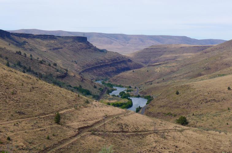
The ride begins with the delightful BLM road between Maupin and Sherars bridge. We have ridden this road four or five times now in the last several years, and every time it has been a wonderful experience. The road hugs the east bank of the Deschutes as it snakes through its narrow canyon, lined on both banks by colorful columnar basalt cliffs. The dramatic landscape with its contrasting colors and shadows is spectacular, in both directions and in all (dry) conditions.
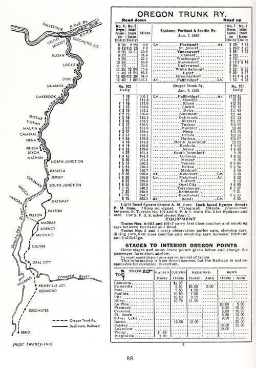
This road and the canyon have a very interesting history, as the site of the last great American railroad war. In 1908, two competing railroad companies battled for rights to the route up the Deschutes and to win the transportation business from the logging around Bend. Both companies were simultaneously blasting out right of way from the basalt cliffs, laying down track and sabatoging their competitors, generally working on opposite banks. Both lines eventually were completed and became operational, producing a railroad map that looked like this in 1920:
| Heart | 0 | Comment | 0 | Link |
Here is a nice description of this history, from the Imperial River Company that operates the inn in Maupin that we stayed at last night.

| Heart | 0 | Comment | 0 | Link |

| Heart | 0 | Comment | 0 | Link |

| Heart | 0 | Comment | 0 | Link |

From Sherars Falls we climb through a small gap in the basalt cliffs and then drop to the White River, which we then follow west to the outskirts of Tygh Valley. This is another beautiful stretch of road that we've ridden several times now but always in the eastbound direction. Riding westbound, straight at Mount Hood, is really spectacular.
Along the way we pass the turnoff to White River Falls campground. We didn't stop in because we've done so twice in the past year already, but also because we're in a bit of a hurry today. It is forecasted to warm to the high 80's, and we want to get past the big climb up the south face of Tygh Ridge before it gets too warm.
If you've been paying attention, you'll have noticed that we passed through Tygh Valley yesterday also. If you put these two maps together, you'll see that the end of yesterday's and the start of today's form a loop from Maupin to Tygh Valley. If you're in the area, this makes a great day ride.


| Heart | 0 | Comment | 0 | Link |

| Heart | 0 | Comment | 0 | Link |

| Heart | 0 | Comment | 0 | Link |
Tygh Ridge is about a 1500' climb, followed by about an equal drop on the other side to Dufur. We've ridden it once before, in the opposite direction. Northbound is a bit tougher - the grade is a bit steeper and the ride is more exposed climbing up the south face - it is on highway 197 all the way to the summit, and there is no protection from the sun. I'm sure it would be a real cooker in the wrong conditions, which is why we hurried a bit to get here today, arriving at the base of the climb before noon.
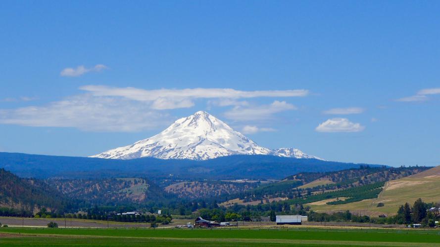
At the summit we turn off onto delightful Old Dufur Road, which follows the summit of the ridge for a short way, giving us spectacular views of Mount Hood of course, but also north to Mount Adams. After that it drops off the ridge and we coast steadily all the way to Dufur, often cycling in the shade beneath oaks and locusts on the greener northern slope of the ridge.
At one point along here I spotted a red tailed hawk a few hundred yards ahead of us rise up from the landscape, with a flock of crows swarming about him like horseflies. They gradually trailed off as he gained altitude, finally breaking free of the last of them. Turning south, he glided directly above us, his wings fully splayed out, the sun streaming through and illuminating his primaries. Breathtaking.

| Heart | 0 | Comment | 0 | Link |

| Heart | 0 | Comment | 0 | Link |

| Heart | 0 | Comment | 0 | Link |


| Heart | 0 | Comment | 0 | Link |

| Heart | 0 | Comment | 0 | Link |
In Dufur we broke for lunch, sitting on the bench outside of Kramers Market, dining on the sun-warmed PB&J sandwiches Rachael brought from home with us, drinking beverages from the store. The next time we come by this way though, we'll pick up lunch here - the market has a fine deli with a good selection to choose from.
After that we took our normal, more or less direct way to The Dalles: Boyd Cutoff Road; a short stint back in 197; Eight Mile Road; Fifteen Mile Road; and then along the Columbia through the eastern neighborhoods before dropping into downtown. We arrived about three and spent the rest of the day loafing around the motel and having dinner at Baldwin's Saloon. It felt great to relax a bit - today was the easy day of our short tour, and we're resting up for tomorrow's long haul over Lolo Pass.
Net elevation gain: 3,500'.
| Heart | 0 | Comment | 0 | Link |

| Heart | 0 | Comment | 0 | Link |

| Heart | 0 | Comment | 0 | Link |
Day 3: To Zigzag (70 miles)
We had a long day ahead of us, so we got an early start. Our cheapo motel didn't have a breakfast option, so we were forced to walk over to Petite Provence for one of their delicious omelets. While we were there we ordered a pair of huge ham and cheese croissants to take away for our lunch. We were their first customers when they opened their door at 7, and were on the road shortly after 8.
We've been just a bit apprehensive about today's ride. At 64 miles and with 6,700 feet of climbing (according to Mapmyride anyway), it is one of the more challenging rides we've taken this year. For the past two weeks though I've been following the progress of the riders in the Trans America Bicycle Race. The leaders have been averaging about 230 miles per day for the last two weeks, and getting by on minimal sleep. Thinking about that makes our challenge today sound quite manageable.
The first twenty five miles follow the course of the historical highway to Hood River. These are miles we've ridden many times now, but somehow they always feel fresh. It is such an inspiring landscape and feels different every time we're here, in different lighting, season or time of day. There is always something new and surprising that I just hadn't noticed before. Today, I'm especially taken by the view from Rowena Crest across to the mouth of the Klikitat River, with its sand deposits reaching far out into the Columbia.
At Rowena Crest we had an interesting chat with a man of about my age. After asking us about out weekend and expressing admiration for our accomplishments so far, he let on that he had done a bit of riding himself in his younger days. Back in the late sixties he took a solo trip from California to Panama. It is so surprising to run across people like this who took on challenges like this when they were younger. He made it sound like the trip of his lifetime.

| Heart | 0 | Comment | 0 | Link |


| Heart | 0 | Comment | 0 | Link |

| Heart | 0 | Comment | 0 | Link |

| Heart | 0 | Comment | 0 | Link |

| Heart | 0 | Comment | 0 | Link |

From Hood River the next thirty miles are generally uphill, broken up by the occasional dip in the profile to cross a creek or river. The net gain is only 3,000' though and it isn't really that bad a climb. The steepest spots are rising out of lower Hood River (the town is split, with the older and lower section along the Columbia but most of the newer development is on a plateau five hundred feet higher) and a steep stretch shortly after LoLo Pass Road splits from Lost Lake Road.
On a day like today, the whole stretch is great. Upper Hood River occupies a beautiful stretch of land, with huge views of Mount Hood and Adams. Once you escape town, you're surrounded by pear and cherry orchards - this place is famously beautiful during spring when it is all in bloom. Beyond that the road drops to and crosses Hood River (the river, not the town) and follows it upriver to the tiny settlement of Dee, where the east and west forks of the river converge.
We followed the west fork as it rises up to Dee Flat where we broke for lunch, enjoying our croissants in a pear orchard beside the road and basking in the idyllic conditions. After continuing to gradually climb along the river on Lost Lake Road, we finally broke off onto Lolo pass Road for the final miles to the summit. For the next hour, I don't recall being passed by a single car.

| Heart | 0 | Comment | 0 | Link |

| Heart | 0 | Comment | 0 | Link |

| Heart | 0 | Comment | 0 | Link |
As we climbed, we puzzled over the occasional signs indicating the distance to the summit and then Zigzag - they indicated that both were about five miles further off than we had been expecting. The explanation came not far below the summit, when Lolo Pass Road turned to gravel and dropped into the beginnings of the Sandy River canyon, but the signed route to the summit bent left and continued climbing.
It looks like somewhere over time this turnoff (forest road 1810) has become the main route, even though this isn't reflected on the maps yet. It is an obviously superior route though - although about five miles longer, it maintains elevation and switchbacks slowly to the summit, while the old road drops about five hundred feet before climbing steeply (about 10%, from my reading of the map) in a much shorter distance. The route we took is unpaved the whole way, but the surface isn't bad at all.
My only quibble as we biked through the trees for the next six miles was that we couldn't see the mountain. I'd been looking forward to the views from this pass but it was looking like we wouldn't be able to see the mountain for the trees. We finally had our reward at the summit, when the two roads reconverged - a huge, unobstructed view of the northwest face of the mountain. Today at least, it feels like the best view I've ever had of it.
Back on the pavement again, the remaining miles to the car flew by as we dropped 2,000' in about 11 miles. Views of the mountain remained spectacular for the first few miles as we followed the clearcut corridor of a transmission line, but then we dropped back into the forest for the remaining distance. Suddenly we emerged from the tunnel of green at busy highway 26, loaded our bikes into the Jetta, and began transitioning back to the real world.
Elevation gain for the day: 6,200'. Stats for the entire loop: 193 miles, elevation gain 15,300'.

| Heart | 0 | Comment | 0 | Link |

| Heart | 0 | Comment | 0 | Link |

| Heart | 0 | Comment | 0 | Link |
Today's ride: 193 miles (311 km)
Total: 1,299 miles (2,091 km)
| Rate this entry's writing | Heart | 1 |
| Comment on this entry | Comment | 0 |