This ride was an initial experiment with using the bus over to the coast. Before this we've always just driven over and taken a loop or day ride. Besides being greener, taking the bus opens up new ride possibilities - we've never ridden home from the coast before.
The experiment was a success, in that it looks like taking the bus will work great. We won't be repeating this exact ride though, because the Wilson River highway is too narrow, and busy to feel quite safe to us, much less enjoyable.
I'm trying to recall the last time I took our bicycles on a bus. Rachael and I did this in Tasmania, back in 2006, to get from Devonport to Hobart. I remember how surprised I was to learn that they would let us just slide it into the luggage hold, unboxed. Before that, I can only recall two experiences, over thirty years ago, on Greyhound. You had to box the bike, and it was enough of a hassle that it wasn't worth it.
Riding the POINT was just like the experience in Tasmania. We just slid the bikes into the hold unboxed, and they came out fine at the other end. No hassle at all. Suddenly I'm looking at maps of the intercity bus network with visions of short local tours that I've never really considered before.
We were't alone. There were two other bikers at the station, both with ambitions larger than ours. A young man (mid-20's?) was on his way to slip his wheel into the ocean at Cannon Beach before setting off to Boston. And Elena, a young woman of about 20, was planning to bike from Astoria to her home in the Bay Area.
I titled this short tour 'Astoria to Portland', but that's a bit of a fraud, because it sounds better. We're actually starting in Warrenton, about five miles west of Astoria, because it's a quieter spot to start biking from; and we're ending in Hillsboro, at the west end of the MAX line, because we don't want to pull a century on the last day. But if we called it Warrenton to Hisllsboro, who would know where that is?
So, we got off the bus at Warrenton, about a half hour behind schedule because the weekend traffic was so awful, but still with plenty of time to reach Garibaldi. At our suggestion, Elena also got off here too. We each went our own way - she went to find lunch, and we headed east toward the Lewis and Clark River. We're taking the inland route to Seaside, taking advantage of a chance to avoid busy Highway 101 for a few miles.
The weather over here could hardly be better - we've picked a great weekend to escape the heat in the Willamette Valley and head to the coast. The route We follow today is one we've ridden and written about a few times before ([page 455830], [page 498375]), so I won't add much to it. Other than a few stretches with heavy traffic on Highway 101 (Saturday afternoon on a day like today is about the worst possible time to be here), this is a great ride. From Seaside south to Cape Lookout is one of the best stretches of Oregon's coast, with one fabulous overlook after another.
North of Seaside, the rather primitive Lewis and Clark Trunk Road is a fairly new discovery for us. It seemed a lot rougher to Rachael this time than before, and she wasn't too keen on it. Maybe it's because we biked it uphill this time, but the last time we were here she loved it.
At the start of the Lewis and Clark Mainline, an old logging road that's been opened to the public for non-motorized use. It sucks you in easily, with smooth pavement at its southern entrance.
A foxglove spear, and some yellow thing I don't recognize. Try as I might, I've never succeeded in sorting out our yellow roadside flowers. There's just no end to them.
Looking south from Seaside to Tillamook Head. The north coast is enjoying a prolonged period of splendid weather - for a week straight its been clear with highs of about 70, with a decent north wind. It's enough to make me wish we were bound for California instead of just out on this weekender.
The long view south from the shoulder of Neakahnie Mountain. Beneath my handlebar you can see Nehalem away, where we'll stop for dinner. Just above the nose of my saddle is Tillamook Bay, where we'll spend the night. The farthest land is Cape Lookout.
In Wheeler by the Bay we stopped for a good fish dinner at the Rising Star Cafe. It was a perfect evening to dine outside, sheltered from the wind, and enjoy some decent local acoustic music.
After dinner in Wheeler by the Bay, we followed the mouth of Nehalem Bay (here, with Neakahnie Mountain in back) and then continued south for the remaining twelve miles to Garibaldi. It was a lovely time to cycle - strong tailwind, most of the traffic had died down - the best hour of riding of the day.
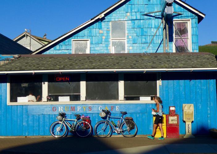
In Rockaway Beach, Rachael walks out of Grumpy's as a happy woman. She's been watching storefronts ever since dinner, looking for a bakery where she could score a cookie for dessert. Success!
We're staying in Garibaldi for two nights, and taking a ragged loop south along the coast to Netarts. We've biked through Garibaldi many times over the years but never overnighted here before. This is the first time I've spent any time looking around, and I find that it's more interesting than I gave it credit for.
Garibaldi is an odd name for this country. It was given by Daniel Bailey, a post-civil War settler who was the first significant land holder here. In 1870, President Ulysses Grant appointed him the first postmaster and commissioned Bayley to provide its name. He named it after his hero Giuseppe Garibaldi, who the same year conquered Rome and completed the unification of Italy.
Surprisingly, it is foggy this morning. I head out before breakfast to poke around the port a bit, enjoying the quiet and watching the procession of fishing vessels making their way out of the marina and disappearing into the fog. Afterwards I return to the inn to join Rachael for breakfast, and then we hang out in the room waiting for the fog to break up a bit. We have a fairly short day ahead, so we take our time getting on the road.
Finally, about 10 we start out. The ride begins with about 10 miles to Tillamook on Highway 101, following the edge of Tillamook Bay. It's not a bad stretch of highway, with an acceptable shoulder except for the occasional bridge. The traffic load is sparse enough that it's not difficult to watch for gaps in the traffic and take the lane when the shoulder disappears.
Garibaldi was wrapped in fog this morning when we woke up, but that didn't stop the fishermen. At our motel, breakfast service begins at 4; and when I walked down to the marina at 6 to look around, a steady stream of fishing boats was headed out to sea.
Engine 25, from the McCloud River Railroad, is one of a stable of old steam engines owned and operated by the Oregon Coast Scenic Railroad. They own about forty miles of abandoned railway track, and operate excursions between Garibaldi and Rockaway Beach.
Beyond Tillamook, we come to one of my favorite stretches of the Oregon Coast - the ride along Bayocean Road to Tillamook Spit, and the short climb over Cape Meares. It's a very quiet road, because we're off the highway now, at the beginning of the Three Capes Loop - the coast road that crosses Capes Meares, Lookout and Kiwanda. But it's especially great now because of the landslide that closed the road connecting Bayocean and Cape Meares the winter before last. The road is pretty badly broken ups and is barricaded now, but it is a wonderful short ride on a bicycle.
On the far side of the cape we bike the spur out to the small Cape Meares lighthouse. It's still a bit foggy out here on the headland, but lovely to bike through the beautiful spruce forest. We can't see far today, but from our visit here last summer we know that the views up and down the coast are spectacular: [page 463903]
Tillamook Spit is huge, extending nearly to the north end of Tillamook Bay, I've occasionally come out here for over 30 years, but tonight at our restaurant I'll learn something new about it: a century ago, the resort town of Bayocean existed out on the Spit, miles from the shore. At the time it was envisioned as the 'Atlantic City of the West'. With a population of about 2,000, It had a resort hotel, complete with a resident orchestra; a thousand seat movie theater; tennis courts, a bowling alley, paved streets, and a post office. The only way to reach the resort town was by crossing the Bay on the Bayocean, the largest yacht on the west coast at the time.
The town destroyed itself though, by building a jetty to calm the waters for the passage across the bay. Unfortunately, this disrupted the currents enough that the spit soon eroded away. Bayocean now is known as 'the town that washed into the sea'.
Looking north to Garibaldi and Neakahnie Mountain from Bayocean Road, at the south end to Tillamook Bay
Bayshore Drive, the road at the end of Cape Mears, has been barricaded for almost two years now, ever since it was ravaged by landslides. Traffic is all routed through busy Route 131 now, but bikes can still get through on this road if they ignore the signs.
Most of Bayshore Drive looks like this - a bit buckled and broken here and there for about a mile, but perfectly safe as long as you're paying attention. And totally quiet and empty - just you and the world. I hope they never reopen it.
A rock face on the north face of Cape Mears, near the lighthouse. It looks like it's rimed with a layer of frost, but this is the effect of the large murre colony that nests on its crags.
Cape Mears lighthouse. We were here last summer also, on a bright, clear day. The view of Tillamook Bay and its spit from out here is spectacular, but you wouldn't know it today.
The Tillamook River, one of the five that empty into Tillamook Bay. Just before taking this shot, we watched a bald eagle swoop low above the water before disappearing into the trees.
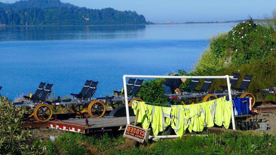
On our way back to Garibaldi we were stopped at a train crossing by the Rail Riders, laughing and waving at us as we waited for the barricade to raise again. Safely through, they're waiting for one of the guides to return after manually lowering and raising the barrier.
Over 700 feet long, Pier's End in Garibaldi is the longest pier in Oregon. I don't imagine the Perth bloggers will be too impressed though - you could line six of these end to end and still come up short against the Busselton Jetty.
We're staying in Garibaldi for two nights, and taking a ragged loop south along the coast to Netarts. We've biked through Garibaldi many times over the years but never overnighted here before. This is the first time I've spent any time looking around, and I find that it's more interesting than I gave it credit for.
Garibaldi is an odd name for this country. It was given by Daniel Bailey, a post-civil War settler who was the first significant land holder here. In 1870, President Ulysses Grant appointed him the first postmaster and commissioned Bayley to provide its name. He named it after his hero Giuseppe Garibaldi, who the same year conquered Rome and completed the unification of Italy.
Surprisingly, it is foggy this morning. I head out before breakfast to poke around the port a bit, enjoying the quiet and watching the procession of fishing vessels making their way out of the marina and disappearing into the fog. Afterwards I return to the inn to join Rachael for breakfast, and then we hang out in the room waiting for the fog to break up a bit. We have a fairly short day ahead, so we take our time getting on the road.
Finally, about 10 we start out. The ride begins with about 10 miles to Tillamook on Highway 101, following the edge of Tillamook Bay. It's not a bad stretch of highway, with an acceptable shoulder except for the occasional bridge. The traffic load is sparse enough that it's not difficult to watch for gaps in the traffic and take the lane when the shoulder disappears.
Engine 101, the pride of the former Port of Tillamook Bay short line, and now owned by the Oregon Coast Scenic Railway. It is claimed to be the only train engine painted in the pattern of a Holstein cow.
Another prize of the Oregon Coast Scenic Railway. They apparently took custody of it after it became trapped at the coast by the great Tillamook flood of 2007.
This chimney is all that remains of the Hammond Lumber Company, the main industry in Garibaldi in the 1920's and for a time the largest lumber mill on the west coast. The mill was shut down in the Great Depression. Before that though, Garibaldi was a company town, with most of the residents working for the mill.
Bay City is the home of the Oregon Coast Railriders, the curious pedal cars we were stopped by yesterday. They operate during tourist season, running 14 mile round trip excursions to Tillamook and back.
Beyond Tillamook, we come to one of my favorite stretches of the Oregon Coast - the ride along Bayocean Road to Tillamook Spit, and the short climb over Cape Meares. It's a very quiet road, because we're off the highway now, at the beginning of the Three Capes Loop - the coast road that crosses Capes Meares, Lookout and Kiwanda. But it's especially great now because of the landslide that closed the road connecting Bayocean and Cape Meares the winter before last. The road is pretty badly broken ups and is barricaded now, but it is a wonderful short ride on a bicycle.
On the far side of the cape we bike the spur out to the small Cape Meares lighthouse. It's still a bit foggy out here on the headland, but lovely to bike through the beautiful spruce forest. We can't see far today, but from our visit here last summer we know that the views up and down the coast are spectacular: [page 463903]
Tillamook Spit is huge, extending nearly to the north end of Tillamook Bay, I've occasionally come out here for over 30 years, but tonight at our restaurant I'll learn something new about it: a century ago, the resort town of Bayocean existed out on the Spit, miles from the shore. At the time it was envisioned as the 'Atlantic City of the West'. With a population of about 2,000, It had a resort hotel, complete with a resident orchestra; a thousand seat movie theater; tennis courts, a bowling alley, paved streets, and a post office. The only way to reach the resort town was by crossing the Bay on the Bayocean, the largest yacht on the west coast at the time.
The town destroyed itself though, by building a jetty to calm the waters for the passage across the bay. Unfortunately, this disrupted the currents enough that the spit soon eroded away. Bayocean now is known as 'the town that washed into the sea'.
Tending the four seater pedalcars of the Oregon Coast Railriders.
We didn't see all that much of interest on the Wilson River Highway, but I liked this. Seems a bit too Portland though for the hardy fishermen I assume stay here.
This is a pretty odd pose, I must say - it looks like I just sprinted in, which is more or less the case. I need to work on my timing for selfie shots. We took this picture because we were here, and because I doubt it will happen again. I couldn't really recommend today's ride.
Dropping from the summit of Clapshaw Road. This must be about the farthest west that you can get a good view of Mount Hood, about eighty miles to the east.