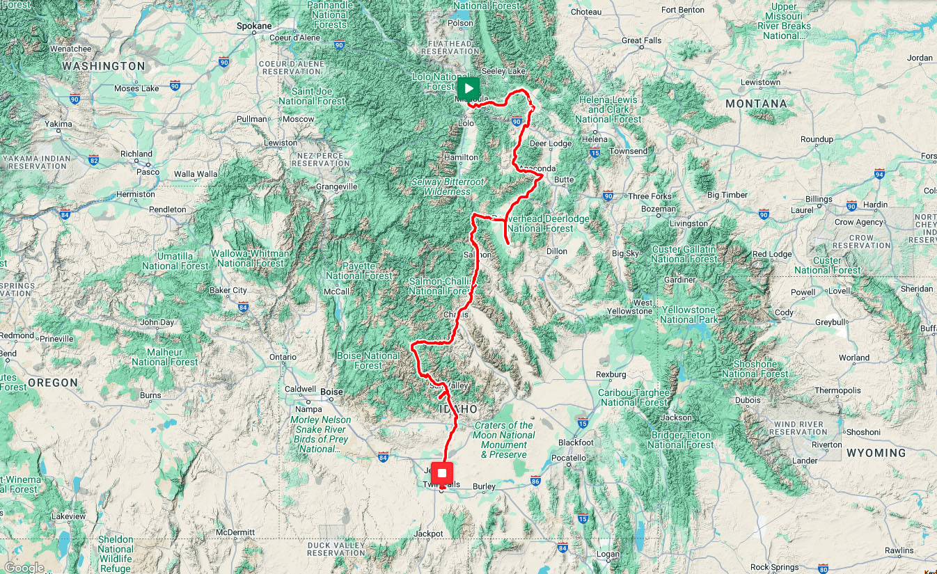
From Missoula to Twin Falls
My bike ride is a 19 day solo motel tour from Missoula to Twin Falls. The route is challenging for me. It's 57 miles shorter than last year's High Desert Rivers tour but it has 3300 feet more elevation gain.
| Heart | 0 | Comment | 0 | Link |
The first half of the tour is in Montana, starting in the cosmopolitan university town of Missoula. The second half of the tour is in Idaho, ending in the big Mormon-influenced farm town of Twin Falls.
Between the small cities is a sparsely populated Rocky Mountain landscape that is excellent for bicycle touring. Five mountain climbs are visible on the elevation profile, but most of the route is gentle grades in semi-arid valleys surrounded by forested mountains.
| Heart | 0 | Comment | 0 | Link |
This is not a new idea. I planned the route and lodging options in detail in 2024, and reserved lodging in January 2025 to ensure that my preferred choices would be available for the June 12-30 tour. Last year I didn't book early enough to get the preferred lodging in Livingston and Bozeman.
The Route
The beginning of the tour took me to a string of remote ranching and mining towns that I had never seen-Ovando, Drummond, Philipsburg, and Anaconda. Five historic lodges gave the Montana segment a Wild West experience similar to my previous tour. The northern spur is a day trip from Wisdom to historic Jackson Hot Springs.
Most of the route is west of the Continental Divide where water flows to the Pacific Ocean. The route crosses east of the divide at a 6772 foot summit south of Anaconda. Wisdom is the only overnight destination where water flows to the faraway Gulf of Mexico.
West of Wisdom the route crosses the Continental Divide again at 7251 foot Chief Joseph pass. Then a short descent to Lost Trail Pass where the route crosses into Idaho and descends 3400 feet to the Salmon river.
I joined the Salmon river at the upstream mouth of the "river of no return". Downstream the river flows through 200 miles of deep roadless canyons. My route goes upstream 160 miles to the headwaters, with overnights in Salmon, Elk Bend, Challis, and Stanley. Then beyond to 8701 foot Galena Summit.
Idaho's Salmon river is the longest undammed river in the contiguous United States. It flows 425 miles, descending more than 7000 feet to its confluence with the Snake river. I pedaled the upper Salmon river in 2008 when I was camping. Will it continue to be one of my favorite routes?

| Heart | 1 | Comment | 3 | Link |
That's an interesting factoid about the Salmon being undammed.
2 months ago
2 months ago
The long hilly descent to Twin Falls had overnights in Ketchum, Bellevue, and Shoshone. I spent a morning on the spur west of Ketchum, attempting to soak at a creekside hot spring that I had never seen. A rail trail made it easy to get through the congested Ketchum to Bellevue resort area. The tour ended with a few miles on the spectacular Snake river canyon rim trail, where my Riding the Snake bike tour began in 2023.
The Schedule
Four days had more climbing than I prefer but those days were spread out, not consecutive. Rest days were scheduled before the two biggest climbs. Three consecutive easy days (10-12) were sort of equivalent to another rest day.
The first rest day was high in the mountains in the historic mining town of Anaconda, Montana. The second rest day was even higher, in the resort village of Stanley, Idaho with great Sawtooth mountain views and two hot spring soaks within walking distance.

I planned the schedule carefully but ended up with one big complication. I spent Sunday and Monday nights in a glamping tent in Elk Bend, Idaho and the only restaurant is closed on Sunday and Monday. There is no store. It was my first time to stuff the new large panniers with a stockpile of food, and my first time to stay in a glamping tent.
The June 12-30 time frame minimized the chance of rain, extreme cold, extreme heat, and wildfire smoke. Days were long because the summer solstice is in the middle of the tour. The schedule avoided the Memorial Day and Independence Day holiday traffic surges. I tried to be in a sweet spot, considering all the factors.
Downsides: Mosquitoes were a nuisance in several high elevation areas that had recent snow melt. The first half of the tour had some rain. The final 1.5 days were in shadeless high desert that is significantly warmer than most of the route.
Hot Springs
I hoped to soak at up to 10 hot springs during this bike tour, mostly natural hot seeps on public land next to rivers. But I actually saw 9 hot springs and soaked in only 4 hot springs. Three days were set aside for hot spring detours. The goal of the two paved route spurs was to soak for the first time at "new" hot springs. The steep unpaved spur at Elk Bend is the hike to Goldbug hot spring.

| Heart | 3 | Comment | 0 | Link |
My 2008 Hot Springing Idaho and Oregon bike tour took me to 39 hot springs. This tour retraces part of that route, but this time I will only stop at the best soaks.

| Heart | 2 | Comment | 2 | Link |
One of my photos of Umpqua hot spring is on the cover of a Falcon Guide called Touring Hot Springs Washington and Oregon. The book also has several of my photos inside. The author is Jeff Birkby, a hot spring consultant in Missoula. I hope to meet him in person for the first time at the start of the tour.
2 months ago
More High Desert Rivers
The Missoula to Twin Falls route starts west of the Continental Divide going up the Clark Fork/Blackfoot river and Flint creek, and down Warm Springs creek to Anaconda. Then a short distance east of the divide going up the Big Hole river.
The route ends west of the divide in Idaho going down the North Fork Salmon river, up the Salmon river, then down the Wood river to the Snake river. The river gradients are plainly visible on the elevation profile.
This tour completes a 3 year project to circumnavigate the High Desert Rivers surrounding the Yellowstone supervolcano. The project began in 2023 with Riding the Snake, along the upper Snake river. Then High Desert Rivers in 2024, following 6 rivers east of the divide such as Wind/Bighorn and Yellowstone.

| Heart | 2 | Comment | 0 | Link |
Easy Logistics
This is an A to B tour far from home. Fortunately, both Missoula and Twin Falls have Enterprise Rent-A-Car locations, allowing me to reserve one way car rentals in both directions. That made the logistics fairly easy. No long term parking or shuttling from A to B in a U Haul truck. No worries that my 15 year old car might break down.
| Rate this entry's writing | Heart | 8 |
| Comment on this entry | Comment | 4 |
2 months ago
Hopefully I will be less exhausted this time. I am taking an entire day to revisit Jackson Hot Springs because their hot pool was drained for weekly cleaning during my 2013 visit.
2 months ago
I remember my ride from Jackson to Chief Joseph Pass in 2023. The descent going north was pretty gnarly with rocks and sand on the shoulder. Hope the southward descent is better. (Not much traffic though.) I also enjoyed the town of Wisdom but there’s some sad history in those parts.
1 month ago
I suppose you are referring to the sad history of the Nez Perce tribe being attacked by US Cavalry at Big Hole battlefield. I plan to stop there to read the exhibits and ponder the history. On previous tours I have passed a few other places that were on the Nez Perce trail of tears.
1 month ago