Conclusion
Useless Statistics
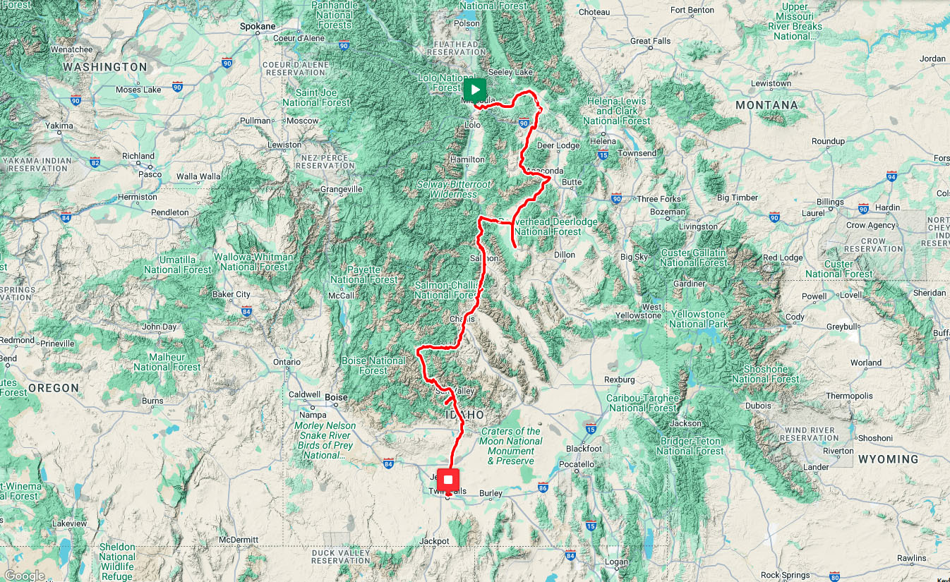
667 miles/1067 kilometers in 19 days.
That works out to an average of 35 miles/56 kilometers per day.
Day 11 was the coldest day with a high temperature of 58F/14C.
Day 19 was the hottest day with a high temperature of 95F/35C.
Rain on 8 of the first 11 days: 1, 2, 4, 5, 8, 9, 10, and 11.
Day 9 had rain mixed with icy chunks at Chief Joseph pass.
Zero flat tires, no bike problems.
Problems with cleat bolts. 2 loose bolts, then one missing bolt.
| Heart | 0 | Comment | 0 | Link |
Useless Opinions
The difference isn't huge, but I like Montana better than Idaho. Montana people seem to be more friendly and open minded. Idaho people mostly want to be left alone, only want to interact with their family. Entitled and self-righteous Karens are more common in Idaho.
Idaho surprised me a bit because the landscape was more volcanic than expected. Now I know that a volcanic hot spot slowly moved across southern Idaho in the last 16 million years.
Is the Salmon river route still one of my favorite routes? The answer is yes, but it's more a favorite in the downstream+tailwind direction than in the upstream+headwind direction. The otherworldly barren volcanic scenery combined with a big river is spectacular and unique.
Favorite towns: Philipsburg and Anaconda.
Least favorite town: Drummond.
Unique Lodging
5 historic lodges in Montana contributed to the Wild West atmosphere of this tour.
1911 Goldsmith's Riverfront Inn in Missoula
1897 Inn at Blackfoot Commercial Company in Ovando
1890 Broadway Hotel in Philipsburg
1902 Hickory House Inn in Anaconda
1950 Jackson Hot Springs lodge in Jackson
The Idaho portion of the tour doesn't have historic lodges, but I found other unique lodging.
A rustic log cabin in Gibbonsville
A deluxe river-view room in Salmon
My first ever Glamping Tent in Elk Bend
Mountain Village resort in Stanley, walking distance from two hot springs
The unique lodging adds local character, helps make this tour feel different from every other tour. It makes the tour more fun, more rewarding. But often more expensive as well.
The Weather
Overall the weather was cooler and wetter than expected. High temperatures varied from 58F to 95F. I successfully avoided heat waves until the last day of the tour in the most likely place-lowest elevation, farthest south, last day of June.
June has more rain than July and August-that's the price of avoiding heat waves. On the plus side, rain helped me avoid wildfire smoke altogether.
Lodging had no air conditioning in Phillipsburg, Anaconda, Wisdom, Gibbonsville, and Stanley. I was comfortable without A/C for this tour because the weather was cool. I used heat in Gibbonsville and Elk Bend. Many of those places would be uncomfortable in typical July or August heat.
Headwinds were as expected. Always a headwind when going west or south, which is most of the route.
I frequently saw snow covered mountains, which I consider to be a benefit from a scenic point of view. Unfortunately the melting snow breeds mosquitoes and other insects. Insects were a nuisance in more areas than expected. It's an inevitable seasonal risk in high mountain areas.
The Roads
Traffic was very heavy for 50 miles east of Missoula, and for the last 50 miles to Twin Falls. Traffic was much lighter for most of the tour.
Recreational traffic during this June tour was noticeably higher than what I experienced in September 2008. Before the tour it didn't occur to me that traffic memories from the September tour won't apply to a June tour.
This was a paved roads tour in a region that has a huge mountain biking culture. The few cyclists I spoke to had no interest in pedaling on highways.
Overall, motorists were polite. Didn't honk or pass closely for no reason.
Hot Springs
During the bike tour I saw 9 hot springs and soaked in 4 hot springs.
Hiked 4 miles with 1100 feet ascent to Goldbug hot spring.
Hiked 1 easy mile to hot springs in Stanley.
During the drive home I soaked in 2 additional hot springs.
During this trip I soaked at 3 "new" hot springs (Jackson, Stanley Osprey pool, Miracle) and saw but didn't soak at Frenchman's Bend hot spring.
High Desert Rivers
The Missoula to Twin Falls route completes an informal 3 year project to pedal all the High Desert Rivers surrounding the Yellowstone supervolcano. The project began in 2023 with a 13 day tour called Riding the Snake along the upper Snake river. Then in 2024, an 18 day tour called High Desert Rivers which followed 6 rivers east of the Continental Divide such as Wind/Bighorn and Yellowstone. It was a fun and rewarding project. I especially like traveling between high desert and forested mountains. It's one of my favorite environments for bike tours.
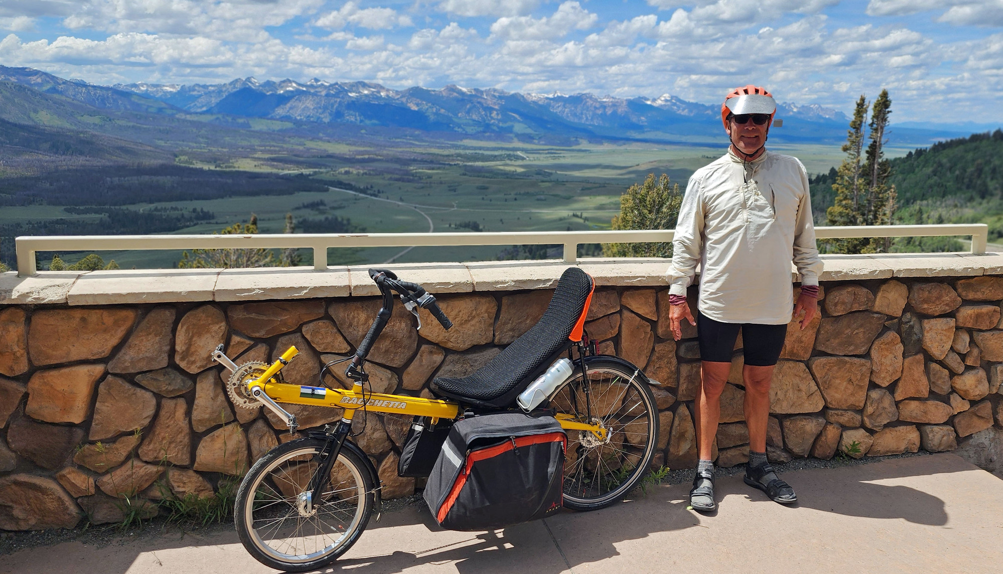
Making this work at age 64
Magnesium Malate supplements seem to aid recovery and reduce exhaustion symptoms. I woke up each morning feeling less exhausted and I had fewer late night hyperventilating panic attacks than previous tours. Only one mild episode of hyperventilating, after getting up in the middle of the night and going outside a rustic cabin to pee on a 45F night. That's a fairly normal response.
On the morning of day 4 I had an episode of pain on the left side of my chest combined with a growing weakness that forced me to stop and lay down 30 minutes. There were a few other instances in the first third of the tour where I started to feel chest pain when working hard, and backed off to make it go away. There were no episodes of chest pain or weakness in the final two weeks of the tour. In August I took a hospital stress test and had no abnormal heart rhythms or blood pressure. My heart rate was 122 beats per minute at the highest intensity level on the treadmill, well below the age adjusted maximum of 138 beats per minute.
I was thoroughly exhausted after the 3 most difficult days (7, 14, and 16) but I felt pretty decent after most days. During the tour I discovered options to split two of the most difficult days in half.
| Heart | 1 | Comment | 1 | Link |
5 days ago
The 3 consecutive easy days (10-12) didn't quite feel like an actual rest day. One reason is that a missed turn added 12 hilly miles on the middle day.
Overall I would rank this as a very challenging tour for me. Longer and hillier than I prefer, but I succeeded. I want to do it while I can, but future tours will be shorter.
The drive home felt like a 2-day extension of the 19 day bike tour. Vastly more fun and scenic than the drive to Missoula which featured long freeway detours and night driving, with no scenic stops.
Making this tour journal after the tour helps me re-live the tour in my mind for more than a month after the tour. Maybe that helps me avoid post-tour blues.
| Rate this entry's writing | Heart | 6 |
| Comment on this entry | Comment | 2 |
Anyway, congratulations on another fine tour and for completing your multi-year high desert river project.
4 days ago
4 days ago