July 28, 2009
Day 19: Hike to Kearsarge Pass
The temperature got down to 58F overnight. Cool enough to actually get in the sleeping bag. I got up at 7 but somehow didn't get on the trail until 8:30 even though I left my campsite set up. No big deal, I have all day. But I do want to get to Kearsarge Pass when the sun is still behind me.
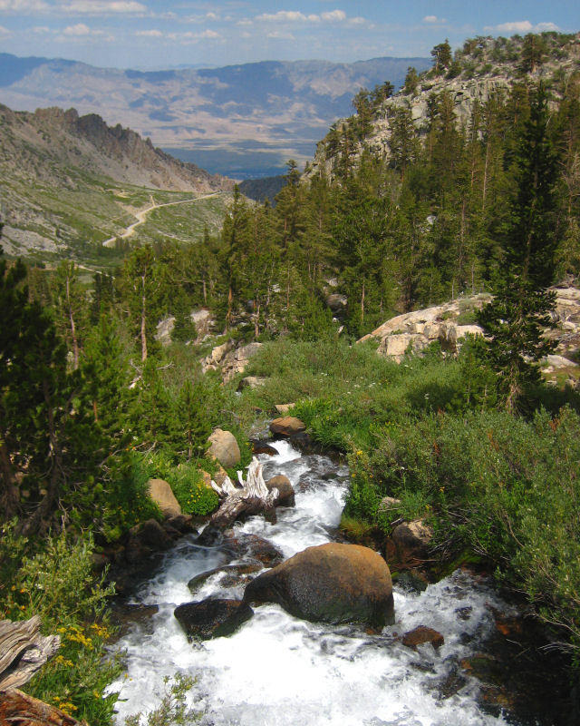
For day hikes I use my large fanny pack which carries two large water bottles. I also have a sun hat that I carry mainly for hikes. On my feet I wear Keen sandals with socks. That's satisfactory for most trails, but weighs less and takes less space than hiking boots. The Kearsarge Pass trail is well constructed, with a level walking surface and gently graded switchbacks. The trail climbs 2560 feet in 4.5 miles to 11,760 foot Kearsarge Pass. It took me 3 hours to get to the summit. I would rate it as an easy climb because the trail is so well constructed. Of course it's more difficult for the hikers with heavy backpacks.

| Heart | 0 | Comment | 0 | Link |

| Heart | 1 | Comment | 0 | Link |
The trail passed near a couple of lakes, and way above a third lake. The first 2/3 of the trail had some shade, but the top part of the trail was above treeline. No shade, but it's not usually very hot at 11,000 feet elevation. The trail had great views most of the time, and the weather was very good. Not totally sunny, but mostly sunny.


| Heart | 1 | Comment | 0 | Link |


I stayed at the summit for an hour. The sun was shining and it wasn't very windy. The temperature was about 70F. I could sit and watch this view for a long time. Kearsarge is at the crest of the Sierra Nevada mountains, with a panoramic view to the west and somewhat of a view to the east.

| Heart | 1 | Comment | 0 | Link |

| Heart | 1 | Comment | 0 | Link |

| Heart | 0 | Comment | 0 | Link |
It took me 3 hours to hike back to the campground. I tried to rest near the lakes, but the mosquitoes were bad there. It was better to rest where it's high and dry. I had bug spray back at camp, but not with me on the trail.
| Heart | 1 | Comment | 0 | Link |
I got back to my campsite at 3:30 and a minute later it started to rain. Good timing! I laid in my tent (needed the rest anyway) and listened to light rain for 45 minutes. The sun was shining an hour later. Later I made a shower, washed clothes, made dinner, and rested.
I refilled my Coleman fuel bottle from a neighbor of the camp host. The campsite costs $16 per night. $32 for 2 nights. After paying for the second night I was down to $2.85 in my wallet. I didn't anticipate that the site would be so expensive.
The climb (by bike and foot) to Kearsarge Pass was worth the effort. I got to see the high Sierra up close, way above treeline where nothing obstructs the views. You can't see that from any road. And I got the thrill of going to the top and looking down the other side. And of course I escaped the heat for a while. The high temperature was only 81F. I left Independence at 11AM yesterday and arrived at Kearsarge Pass at 11:30AM today. 24.5 hours to get from 4000 feet elevation to 11,760 feet elevation.
Tomorrow I will go back down to the Owens valley for one last day in the heat.
Biked 0 mi.
Hiked 10 mi (16 km)
| Rate this entry's writing | Heart | 0 |
| Comment on this entry | Comment | 0 |