February 1, 2022
Vineyard Canyon
This has become our normal daily routine now: wake up about 6, turn on the heat, brew some coffee, check the weather, confirm that it won’t be warm enough to ride until around eleven, and settle in for a longish wait. While we wait we consider the wind predictions, review the ride candidates, and make our choice for the day.
Today, with a moderate north wind expected to amplify in the afternoon, a ride up Indian Valley Road looks like the best solution. With its north-south orientation it angles up the eastern slope of Salinas Valley for 25 miles and a steady but modest grade. We’ll just bike up as far as we care to go and then turn around, coasting back to the car with the wind behind us.
It’s a short, fast seven mile drive north on 101 to San Miguel where the ride starts. When we pull off the highway we’re immediately faced with the bell tower of the San Miguel Mission. The sign next to it states that the mission was established in 1797, and I’m impressed at how well preserved the bell tower is. Further research though reveals that although the mission is old, the bell tower is not. In fact, it’s a World War II memorial erected in 1950 for a former superior of the mission who was killed in action.

| Heart | 1 | Comment | 0 | Link |
Still, we don’t know that at the time and are impressed by it and the mission itself with its colorful lichen-encrusted tile roof. We park the car next to it about a mile before where we had intended to start the ride and spend a few minutes looking around before unloading the bikes. Rachael’s plan is to backtrack with the bike a few hundred yards so she can include the mission in today’s video - but that idea quickly gets tossed when she discovers that she forgot to pack her GoPro this morning.
So, no video today. Sorry. If you’re desperate for some video to start your day, I recommend that you go back and rewatch the sea elephant video from yesterday. It will make you feel better inside.

| Heart | 1 | Comment | 0 | Link |


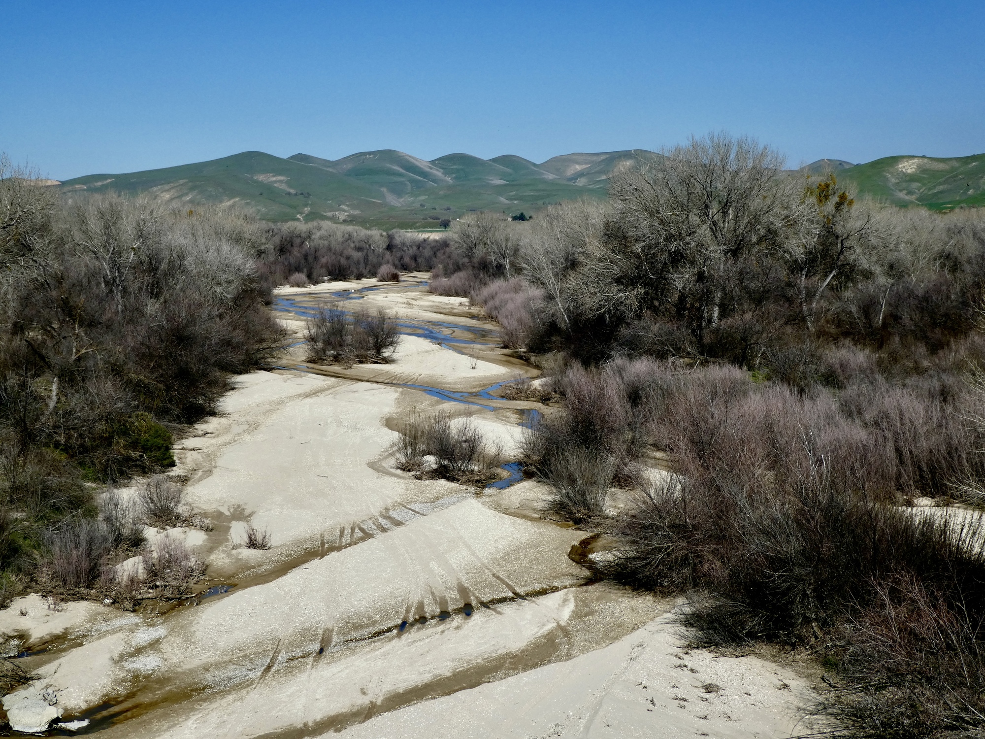
It’s still chilly enough to require our coats as we bike north out of San Miguel, cross the Salinas River, and turn north on Indian Valley Road. It doesn’t take long though for us to find that the situation on the ground is different than we’d imagined. Indian Valley Road looks like a scenic, quiet ride, as long as no cars come by - and it’s a lonely road, so they don’t come along often. When they do though, they’re quite loud because they’re rattling on the bone-jarring road surface. It’s paved, but with a rough rocky asphalt surface that’s definitely no fun on these bikes. Dirt would be much better.
We give it a few miles - just long enough to see that it could be exceptional, especially when we’re startled by a red tailed hawk flying low across the road just ahead of us, a hapless ground squirrel dangling from its talons. We watch in amazement as he flaps across the field and then suddenly drops his load either because he lost his grip or perhaps found it too heavy to fly with.
So that encourages us to continue on, for awhile. It doesn’t take much longer though for us to decide that this is one of those roads that we rode so you don’t have to, and turn back.
| Heart | 3 | Comment | 2 | Link |

| Heart | 3 | Comment | 2 | Link |
2 years ago
Fortunately there’s an alternative just behind us: Vineyard Canyon Road, which we passed the turnoff to two miles back. Its surface looked much better than the one we’re on when we passed it earlier, and it’s a semi-known entity because it was another of our ride candidates and is already loaded on the Garmins. We bike back and start up it instead, not all that excited about its surface at first either - until after about a mile we come to the Monterrey County line and conditions improve considerably.

| Heart | 2 | Comment | 0 | Link |

So we’re back on the usual plan - an out and back, and I’ll see Rachael when I see her. This ride doesn’t meet our specs quite as well - it’s more of a hill climb, and its east-west orientation means its winds are less favorable today - but we’ll just ride it as far as works for us and then turn back.
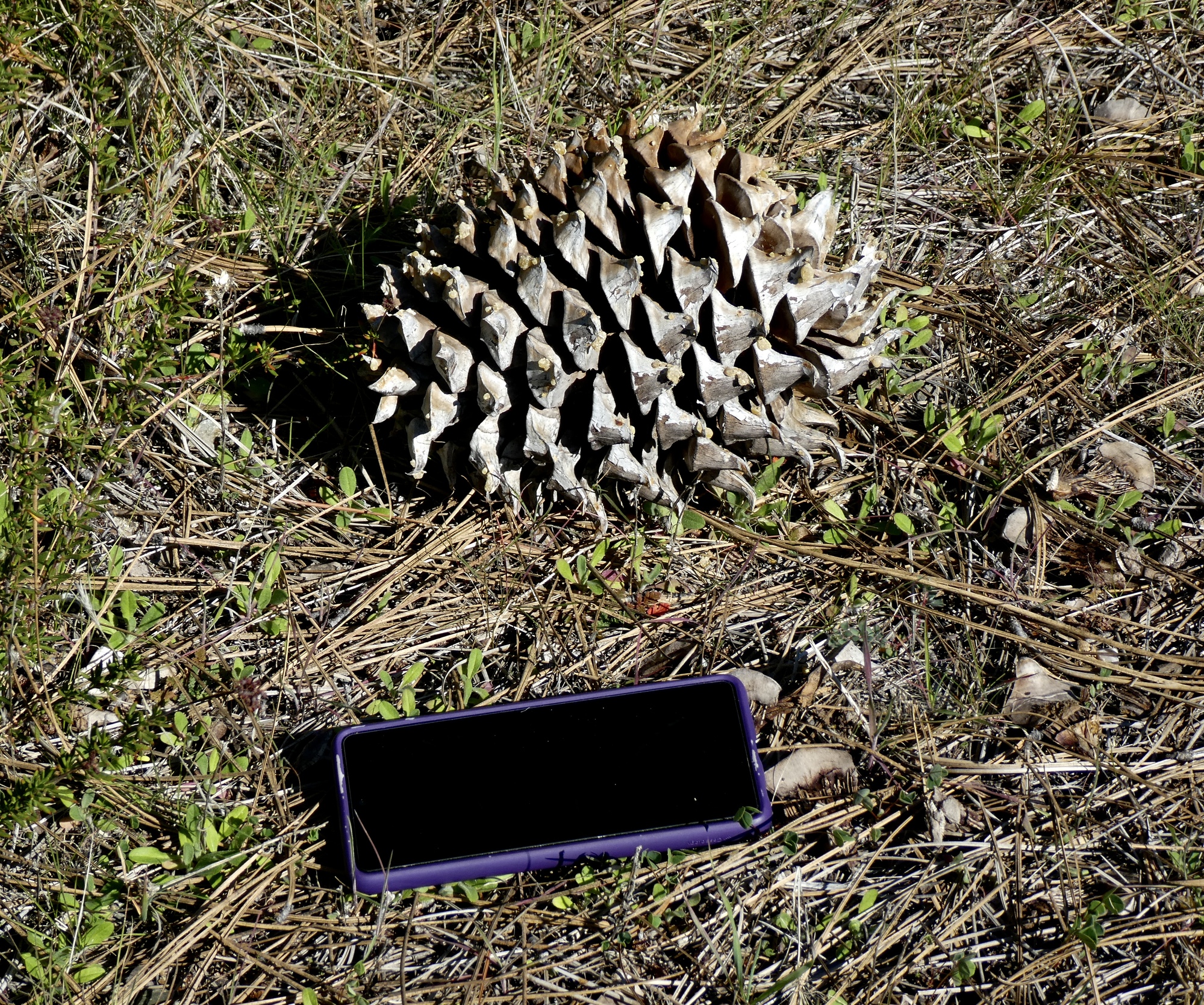
Paso Robles is proving to be quite the base for a cycling holiday. Today’s is our fourth ride on the interior roads near here (you’ll recall that we rode up into Hog Canyon two months back on our way south to Tucson), and all four of them have been exceptional in different ways. Today’s isn’t really like any of the others. It’s more wooded, with Foothill Pine (Pinus supiniana, also known as the gray pine or Digger pine) and Coast Live Oak the dominant species.
I’ve never biked through a treescape quite like this, and am especially impressed by the pines, which at first I misidentify thinking they’re Coulters because of the huge cones littering the side of the road. It’s daunting to bike along and see piles of these spiky giants beneath the trees and on the shoulder of the road, and I’m careful to stay toward the center of the lane.
It’s another fine environment for birds also. Many sparrows and meadowlarks once again, as well as jays and bluebirds. And I’m startled when I look up the road and see a roadrunner crossing it about fifty yards ahead. He disappears around a bend and I’m concentrating hoping to spot him again as I round it when a loud whirr erupts just off my left shoulder and about sixty quail explode out of the roadside brush. I don’t see the roadrunner again, but a quarter mile down the road a flock of about thirty turkeys flies low across it and disappears again into the shadows. And when I catch up with Rachael later she’ll tell me that she saw deer today.
The one thing not seen along Vineyard Canyon Road though is vineyards. Not a one. Early in the ride is a massive spread of young nut trees that looks newly planted though, so maybe it used to be a vineyard that got ripped out and replanted? A mystery.


| Heart | 1 | Comment | 0 | Link |
| Heart | 1 | Comment | 0 | Link |


| Heart | 3 | Comment | 0 | Link |


| Heart | 0 | Comment | 0 | Link |
Until now it’s been a comfortable ride, rising gradually at maybe two or three percent. Abruptly though it changes as the road nears the crest, and the next two miles climb at a steady 10-11% through an attractive rugged terrain. I’d like to make it to the top but don’t really expect to, knowing that Rachael is ahead and likely to turn back before I get there.
When I do reach the top though, there she is waving at me from the shoulder of the road in a perfect picnic spot. She biked further than that, dropping steeply off the far side of the ridge for about a half mile before thinking the better of it and climbing back up. She’s just finished her own lunch and waits with me while I do the same, I sitting in the dust and enjoying the fine views and the rest of last night’s pizza.

| Heart | 1 | Comment | 0 | Link |

The ride down is not quite as expected. It’s all downhill and fast of course, but we have a significant headwind. It was warm enough sitting around eating lunch, but not when racing downhill into the wind. I start out with only my long sleeved jersey as the added layer, but five miles on I finally give up and stop to put my coat on. It’s a relief to finally make it back to the car, having stopped only long enough to admire a coyote that crosses the road ahead of me and then works its way up a steep slope, stopping regularly to turn back and check to see if I’ve still got my eye on him.
So, maybe not Indian Valley Road if we ever come back here again. Definitely this one though. Vineyard Canyon is a keeper.

| Heart | 2 | Comment | 0 | Link |

| Heart | 2 | Comment | 0 | Link |


| Heart | 3 | Comment | 0 | Link |
Ride stats today: 39 miles, 2,600’
Today's ride: 39 miles (63 km)
Total: 2,225 miles (3,581 km)
| Rate this entry's writing | Heart | 6 |
| Comment on this entry | Comment | 2 |
2 years ago
2 years ago