March 13, 2021
Marble Canyon
Road trip, with a bit of hiking tossed in. We’re moving to Marble Canyon today for a one night stand. There’s nothing in Marble Canyon itself - I’m not sure it’s actually a named place - other than the motel/restaurant/gift shop/service station complex we’re lodging at. It’s in a regionally famous location though that many will recognize - right by the Navaho Bridge(s) that span the Colorado River, and about five miles downriver from Lee’s Ferry, the traditional launching spot for rafting trips down the Colorado River and through the Grand Canyon.
It’s lightly snowing when we get up this morning, and continues to snow nearly until checkout time at 11. We have a choice of itineraries, and I’m torn between them because I’ve bicycled them both and would love to see either of them again to refresh my memory. The most direct route, shorter by 15 miles, goes east through the infamous Zion Tunnel and across the Checkerboard Mesa to Kanab and then south to Fredonia. The indirect route goes back west to Hurricane and then climbs up through Colorado City before dropping to Fredonia. From there the routes converge to the famously scenic route 89A, climbing over a high plateau to Jacob Jake at 8,000’ and and then dropping to follow the Vermillion Cliffs until reaching our destination.
We base our decision on the weather forecasts, and choose the Jacob Lake route. Our main concern is the risk of snow at the highest elevations, and even though Jacob Lake is higher at nearly 8,000’, the forecast indicates that it will be dry all day.
The snow has ceased and the sky is clearing when we leave Springdale. We enjoy wonderful views of sparkling, snowy mountains for the next hour, but halfway up the long climb to Jacob Lake the sky darkens again; and in spite of the forecast we find ourselves driving into a significant snowfall when we reach an elevation of 7,000’. With the snow beginning to cover the highway and another five miles ahead to the summit, we slow down and wonder if we’ll have to reverse tracks and take the low road. Then, suddenly, the snow stops and the road is clear to the summit.


| Heart | 2 | Comment | 0 | Link |

The descent from Jacob Lake and along the stunning Vermillion Cliffs is truly astonishing. I’m happy to see this road again, even if only by car - my ride from Fredonia to Lee’s Ferry is one of my richest cycling memories. When we begin the descent skies are grey and foggy in the distance and it doesn’t seem like we’ll see much of these famous red cliffs that we’ll follow for the next 25 miles; but then suddenly the sun breaks through.


| Heart | 1 | Comment | 0 | Link |
A few miles from Marle a canyon we’re lured in by an unmarked attraction - an area of huge, grotesque boulders strewn across the plain and a few stone structures built around them. This part of the country is endlessly astonishing. You could really start anywhere and be assured of seeing things that will blow your mind within twenty miles in any direction.


We checked in to our room at Marble Canyon Lodge and then immediately drove out to Lee’s Ferry for a walk. We found a short but good one following the shore of the Colorado River upstream, but managed to turn it into a stressful and even frightening experience. As usual Rachael got well ahead of me while I stopped with the camera. The plan was that we would meet up when she turned back. Perhaps a mile into the hike though the official trail ends; and beyond that it becomes fainter, rockier, and more of a scramble.
We started the hike impulsively without much forethought. We didn’t establish a time to turn back or the fallback plan if we failed to meet up somehow, and had no means to communicate. Worse, through a misunderstanding we had different ideas about how far the trail would go. Rachael thought it went two miles (as it showed on the GPS), and I thought only a mile, as the signs indicated.
Eventually, I decided we must have missed each other somehow and turned back to the car, hoping to find her there. Nope. I backtracked again, hoping to find her still on the trail, but was getting seriously worried that something had happened to her. It was a huge relief when I saw her turquoise jacket off in the distance.
Beautiful hike though, otherwise.


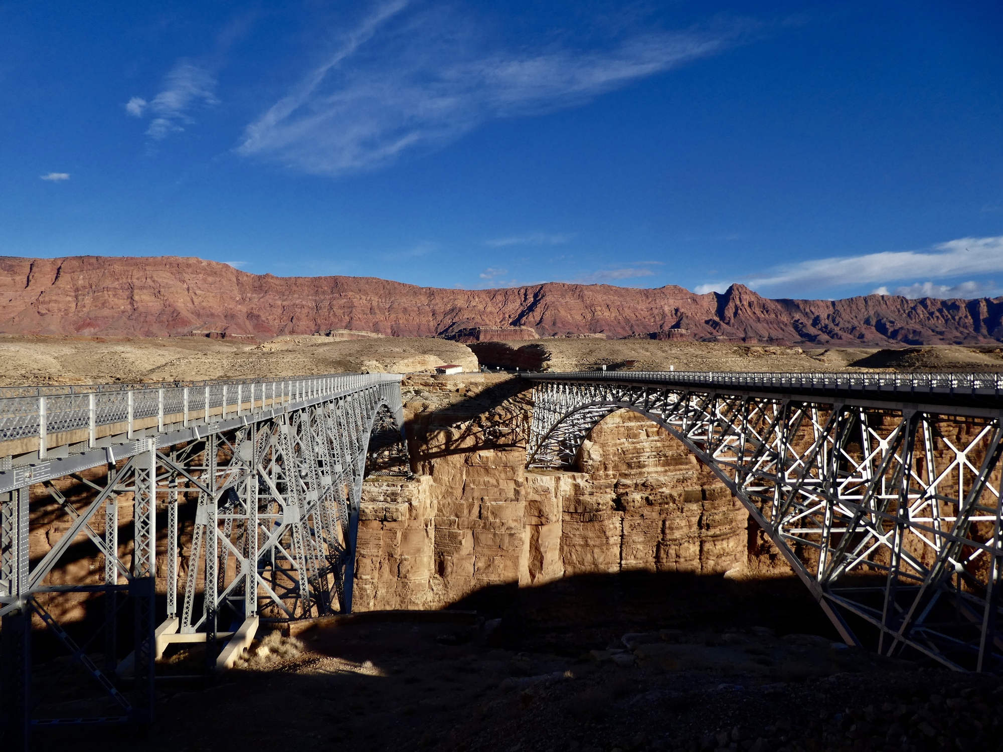
Reunited, we stopped to look at the famous Navajo Bridge on our way back to the motel and dinner. The original bridge, opened in 1929, is a magnificent steel single span arch, an awesome 470 feet above river level. I biked across this bridge back in 1987 en route to the Grand Canyon, and had mixed feelings about seeing it again because since then a second bridge was built to support the heavier loads of modern traffic. I pictured the scene being marred by the addition of a more modern bridge, but was delighted to see that the new bridge was built in the same style as the original. The twin bridges are really a beautiful sight, and looking down the immense canyon is breathtaking.
| Heart | 2 | Comment | 0 | Link |

| Heart | 2 | Comment | 0 | Link |


| Rate this entry's writing | Heart | 6 |
| Comment on this entry | Comment | 5 |
3 years ago
3 years ago
3 years ago
3 years ago