June 1, 2023
Day 29 - June 1 - Lexington, MO to Watkins Mill State Park, MO
Out of the River Valley
Ed’s Story
Went to bed at 9 o’clock last night. I was up and ready to go by 5:30, or at least, I was just getting out of bed then. Since we camped inside, there was no damp rain fly to take down.
Packed up; ate breakfast; then said goodbye to the Big River Ranch. As I said yesterday it was a dirt/gravel road to get to the campsite. Everything was fine on the ride out until I started going down the last hill. The gravel was especially loose on the hill. I lost traction and went over. Luckily, I fell over on the non-drive side so I didn’t damage the chain ring or the derailleur.
I did slightly twist the handlebars and get a nice scrape on the bottom of my leg. Luckily, I had found my Band-Aids earlier so I patched myself and my bike up and were off again. I know I didn’t have any gravel in my leg as John did previously, but it was traumatic enough.

We got on Missouri Highway 13 and headed toward the Missouri River bridge. This road is a four-lane divided highway with a speed limit of 70 miles an hour.
The berm was wide enough to allow us to cross safely and to allow us to stop and take a picture of the river, the mighty Missouri.


| Heart | 2 | Comment | 0 | Link |
We continued riding on 13 until we reached Henrietta. We had considered camping there last night, but the RV park that has been previously listed with the Eastern Express route information no longer existed. We headed out of town, turned and west what did we see?

| Heart | 5 | Comment | 0 | Link |
We continued riding, and I had to stop suddenly to avoid hitting something in the road. Look at the size of that thing.
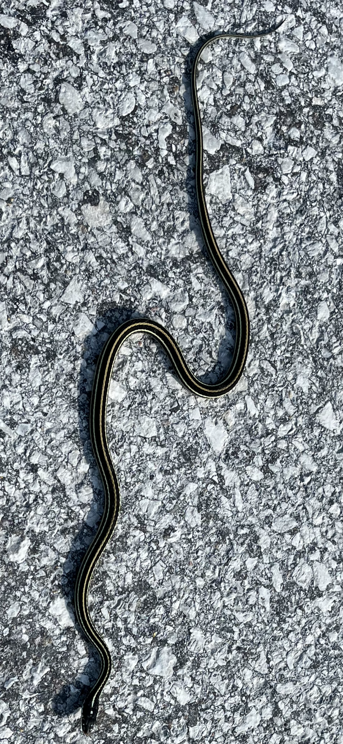
| Heart | 4 | Comment | 0 | Link |
This historical marker was in the same area as the snake.


After leaving the area it was time for a rest stop. We came across the Crossroads convenience store around the town of Orrick. I never saw the man working there smile. If you remember the TV show Hee Haw, the man working there sort of had the appearance of Junior Samples.

Over the next 15 miles we climbed numerous long and steep hills to climb out of the river bottom. I think we previously mentioned how our GPS devices will tell us when there is a Climb approaching. Some of the hills we climbed were not identified as a Climb but were steep nonetheless.

| Heart | 1 | Comment | 0 | Link |
We reached Excelsior Springs where we stopped for lunch at the Willow Springs Mercantile. I had a Greek spinach rollup, and tortilla chips with cowboy caviar. Also, two beers of course since we only had 7 miles to go.

| Heart | 2 | Comment | 0 | Link |


Bought our dinner supplies and as we were getting ready to leave, I dropped my Wahoo GPS and cracked the screen. It is no longer waterproof.

| Heart | 4 | Comment | 0 | Link |
We arrived at Watkins Mill State Park. We’ve normally gone down a hill to a riverbed or a lake to camp at some of the state parks. When we arrived here we actually climbed up into the park. I guess it’s a fitting ending to the day.
Set up our tents; showered; and washed our clothes. All that’s left is to eat and go to bed. “After all, tomorrow is another day.” Now guess the movie reference.
We’ve seen more poison hemlock and poison ivy in Missouri than in any other state. It’s interesting as in some areas it looks like they’re actually growing poison hemlock because there’s nice rows of it. I did a quick Google search and could find no useful application for poison hemlock. Curious!
Tomorrow we leave Missouri and head to an overnight in Atchison, Kansas. Expect to ride about 69 miles. The campground is about 2 miles south of town.
Well readers, until tomorrow happy biking!
Just thought I would get everyone up to date on the beard challenge. It has now been 28 days.


| Heart | 2 | Comment | 0 | Link |
John’s Story
If you’ve recovered from the shock of seeing’s Ed’s selfies above, we can proceed.
Ed does not exaggerate that the road into and out of Big River Ranch is a pain in the rump (and in the leg in Ed’s case) to ride on a bike. I hope not to see any more road like it between here and the Pacific Ocean.

| Heart | 0 | Comment | 0 | Link |
It was an exhilarating downhill ride from near the road that ate Ed’s leg to the Missouri River bridge and our re-entry onto the floodplain. I knew we would pay the price later in the day.

| Heart | 5 | Comment | 2 | Link |
Ed complained about the fast moving traffic and the barely rideable berm. There were actually two rumble strips cut into it, an older, wider, shallow one in the center, and a newer, narrower, deeper on the left. We had to thread the needle between the shallow rumble strip in the center of the berm and the right hand edge of the berm. I pointed out to Edward that had there been another alternative to crossing the river in this area we would have taken it. Early on I dismissed the idea of building a raft and poling our way across.
A few weeks ago I posted a picture of corn a few inches high with the comment that it was this summer’s corn on the cob. As we’ve pressed westward I’ve noticed that the corn keeps getting higher. At first I was thinking that perhaps in warmer areas like Missouri the corn gets planted earlier so it’s naturally higher here. The realization came to me today that, no, the corn was probably just a few inches high here when I took that original picture farther east, and the corn everywhere has been growing over the weeks we’ve been on the road.

| Heart | 2 | Comment | 0 | Link |
If anyone out there is looking for an old bus to turn into a camper, have I got a deal for you! Only $11.50 for this classic!

| Heart | 4 | Comment | 0 | Link |


| Heart | 2 | Comment | 0 | Link |

| Heart | 2 | Comment | 0 | Link |

| Heart | 3 | Comment | 0 | Link |

| Heart | 4 | Comment | 0 | Link |
We finally climbed the last of the big hills, and were rewarded with more, lesser hills leading into Wood Heights.
Today was a day of dogs. It seemed at one point we had most of the dogs in the county barking at the same time, and some of them chasing after us. Ed is especially vulnerable riding down the road in his low slung recliner. And it seemed that most of the time there were dogs Ed was in front of me so he got their attention first, and they were either worn out from chasing him or just lost interest when a second biker came by.
As we rode through the back streets of Wood Heights this dog came roaring off the porch to confront us with violent barking and growling and posturing. Because once again we were on a hill, we were going really slowly as we approached. The dog stopped just short of reaching us on the road and barked furiously at us. I just started talking to the dog in a normal tone of voice. “Nice dog. You’re doing a really good job of defending your home. I’m proud of you. I hope your masters are watching and realize what a good watchdog you are.” And so forth. After a moment the dog stopped barking. As I continued talking he cocked his head to the side as if he were trying to understand me. He sat down as I continued to talk. Then he laid down. And finally he rolled over on his side and looked ready to take a nap. We rolled onward with no further interference. I wish this worked with all dogs.

The two beers that we each had at lunch did not help us climb the next 7 miles of hills to reach the park. Perhaps they numbed the pain however. In a final fit of pique the Missouri landscape continued to tilt uphill to our very campsite. Ed says had he known the topography better he would’ve selected a campsite farther down the hill. On a favorable note, the shower house has a laundry room with one washer and one dryer. We were able to wash clothes for only one dollar for each machine. We’ve paid up to four times that in motels.
There has been rain lurking out there all day. We actually felt a few drops as we left Excelsior Springs for the park. We heard thunder for several hours after we arrived here, and the sky was pretty well clouded over, but it never rained. All the storms are north of us and moving away. It should be a dry night.

Today's ride: 45 miles (72 km)
Total: 2,628 miles (4,229 km)
| Rate this entry's writing | Heart | 7 |
| Comment on this entry | Comment | 1 |
'a dog whisperer!'
And Edward, your hair didn't turn gray on this trip. You have been in denial for a while, and just now accepting it.
2 years ago
2 years ago
2 years ago