June 8, 2019
Day 11: Taos to Mora, across the Sangre de Cristo mountains
Today has more climbing than any other day of the tour. Two 1600 foot (485 m) climbs, plus a few smaller hills. I hoped to get an early start but the 7 AM breakfast was served late and I spent a long time talking to people at breakfast. Finally on the road at 8:50.
I biked the main roads past Taos Plaza, then turned onto Salazar road to go south to Ranchos de Taos. Salazar road has bike lanes and bypasses all the traffic on NM 68, but it also bypasses all the services. I enjoyed the low traffic road and wish there was a similar back road north of downtown.
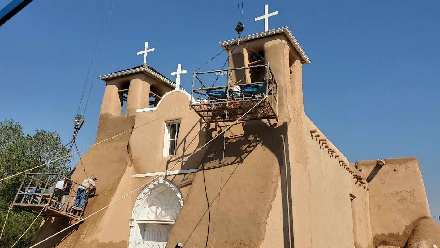
Salazar connects to NM 68 in Ranchos de Taos. I pedaled nearly a mile on busy NM 68 to get to San Francisco de Asis Catholic church. It's historic and very famous. For a few million dollars you can buy an original Ansel Adams photo or Georgia O'Keefe painting of this church.
I was thrilled to see the annual mudding in process. I had never seen that before. It's a big volunteer project for the church, takes about a week to complete with the help of two big cranes. A self-appointed tour guide lady talked to me about the church for about 20 minutes, with much repetition.

| Heart | 0 | Comment | 0 | Link |
Adobe is high maintenance because rain and wind slowly wear away the materials. The outer mud coating must be replaced periodically. Despite the required maintenance, most the world's oldest surviving buildings are made with adobe, some more than 2500 years old. The internal bricks are made of clay mud, straw and sand. There are no timbers reinforcing the walls so the wall thickness is typically 3 feet (1 m) or more to provide the necessary compression strength and lateral stiffness.
| Heart | 0 | Comment | 0 | Link |

| Heart | 0 | Comment | 0 | Link |
Leaving the church and winding through Ranchos de Taos was a real treat. A no traffic, narrow and probably centuries-old road lined with split wood coyote fences. The name of the road is El Camino Abajo de La Loma (the road below the hill). Other than the asphalt and power lines it probably hasn't changed much in 200 years. This area is part of the 1710 Cristobal de La Serna land grant. Many farms are owned by descendants of the original settlers.

| Heart | 0 | Comment | 0 | Link |
Talpa is the last settlement before I climb into the mountains. It looks very depressed. But the little chapel is quite a sight. The bells were ringing when I arrived. Two tourists had requested a keeper to come and ring the bells for their entertainment, and to record video on their phones.


After Talpa, NM 518 promptly climbs into forested mountains, going mostly south. Today's route is mostly forested. The road climbs steadily alongside the Rio Grande del Rancho, a tributary of the main Rio Grande. It's mostly Carson National Forest but there are some big private in-holdings. Most notable is the "SMU in Taos" campus (conference center?) on the site of what was once an Army post called Fort Burgwin.

| Heart | 0 | Comment | 0 | Link |
I went into SMU Taos and took a rest stop on the bank of the river. It's nice to see and hear the water and be in forest again.

| Heart | 0 | Comment | 0 | Link |
This morning I am on the famous high road to Taos which goes from Española to Taos. I biked the entire route during my first bike tour in 1988 but today I pedal only the northern third of that route.

| Heart | 0 | Comment | 0 | Link |
NM 518 climbs steadily with a grade of only 3 to 4 percent. It's an easy way to climb 1600 feet (488 m) to the first summit at 8560 feet (2594 m) elevation. It's not a major mountain divide so I wasn't surprised that there is no summit sign. There is, however, a signed scenic overlook with a parking area and railings. Traffic is very light. It's a road to nowhere.

The descent from the first summit is only 750 feet (230 m) before I connect with Rio Pueblo and start climbing upstream to today's second pass. It was pleasantly warm and sunny and now I go east with a nice tailwind. Today was the only day of the tour to have a blue sky afternoon.


Along Rio del Pueblo seemingly in the middle of nowhere I passed the FaYun Prajna Buddhist monastery which has a big sign with mostly Chinese characters.

Partway up the second pass is the Sipapu resort. I was glad they were open and serving lunch. I was very hungry and still had more than 1000 feet (305 m) of climbing to go. The riverside deck is awesome, extremely close to the river with a view of ski slopes across the river.

Sipapu is a small family owned ski area and summer resort. Much smaller than the Taos, Santa Fe, Angel Fire, and Red River ski areas.

| Heart | 0 | Comment | 0 | Link |
It felt good to be well fueled for the final climb. I enjoyed the river, cliff, forest, and mountain views. Traffic was light and the grade is surprisingly easy. The grade tops out at 5% for only the last 200 feet of climbing.


The second summit is 9477 feet (2872 m) elevation, the crest of the Sangre de Cristo mountains. I was surprised that there is no summit sign. I can't find a name for this summit on any map so I will call it Sipapu pass. Or maybe it should be called Del Pueblo pass?
I reached the summit at 5:30 PM, later than I wanted. My phone rang at the summit. It was the motel in Mora, wondering when I would arrive. She told me the only restaurant in town closes at 7 PM.

| Heart | 0 | Comment | 0 | Link |
I enjoyed the long descent to Mora with the sun on my back. I had a tailwind going east up the mountain, but had a headwind going east down the mountains. Wind blew up the mountain on both sides. I didn't take many pictures because I was in a hurry to get to Mora before the restaurant closes.


| Heart | 0 | Comment | 0 | Link |
Mora is a sleepy ranch town in a remote mountain valley 30 miles northwest of Las Vegas, New Mexico and I-25. No tourists, no artists, no wealthy retirees. A different universe from Taos. Mora is in the 1835 Mora Land Grant from the Republic of Mexico. Settled by farmers of Spanish descent, but strangely I see several Protestant churches and no Catholic church. Mora seems to be more of an Anglo town now.
I checked into the motel, $69, then rushed another 1.9 miles into town for dinner at Main Street Diner. They didn't have India Pale Ale so I had Shiner Bock instead. Everybody sounds like they're from Texas.
I don't like it when the restaurant is so far from the motel. The motel advertised that they have a restaurant but it's only open for breakfast and lunch. And it's closed on Sundays, tomorrow. So the motel's restaurant never opened while I was in Mora.
Today had a high of 80F (27C), the only day of the tour to be sunny all day. It stayed warm outside until about 9 PM. Warm weather and gentle grades made the two big climbs seem easy.
Distance: 51.6 mi. (83 km)
Ascent/Descent: +3634/-3216 ft. (+1108/-980 m)
Average Speed: 8.4 mph (13.4 km/h)
Today's ride: 52 miles (84 km)
Total: 386 miles (621 km)
| Rate this entry's writing | Heart | 0 |
| Comment on this entry | Comment | 0 |