June 30, 2016 to July 1, 2016
Across the border to Glacier NP and the Going-to-the-Sun Road
My day's ride from Belly River to the border, and from there to the entrance to Glacier National Park at St. Mary, Montana was a short 52 kms -- deceptively short, as it turned out.
The border post opened at 7 AM, but I chose to make a leisurely start, and after a 4 km climb, reached the border about 8:30. I stood in queue for the better part of half an hour, during which time I had to ask motorists to switch off their motors. Guess they didn't know (didn't care?) that their catalytic converters don't work at idle, and that that's not much fun for any pedestrians or cyclists beside them. From the border to the junction with US 89, running south to St Mary, is a further 24 kms. The total of 28 kms took me 2 1/2 hours, over several long hard hills. The 8 km downhill into the village of Babb, my lunch stop, took me straight into a fierce headwind, a sign of things to come.
The Glacier's Edge Café in Babb is a fine spot for lunch, and I managed to find a table and place my order just before a coachload of tourists arrived. I asked the young fellow who was cashier, maître d' and chief waiter for his recommendation on a grocery store. He advised me to go across the street to Babb's general store--their prices, he said, were much better than those at the supermarket in St. Mary. I did so, and restocked at leisure and at good prices.
As I was repacking my panniers, a voice said, "You left this, sir." I looked up, and the young fellow who was the Glacier's Edge cashier, etc., handed me my 1.2 litre Sigg water bottle, which I'd managed to leave behind on my table. I thanked him for his thoughtfulness, and apologized for my senior's moment. In this first week, his was just one of several similar small acts of kindness. While I was still getting my micro-routines re-established, I managed to drop or forget maps, odds and ends, and here, a water bottle, only to be rescued by staff or other customers. Nothing was irreplaceable, but I was nonetheless grateful to friendly strangers for paying attention, if slightly embarrassed that I wasn’t.
At the St. Mary campground, I shared a hiker-biker site with John and Shirley, from Washington State en route to Jasper. We compared notes on climbs and winds. They mentioned that a good tailwind had pushed them up the western slope and followed them down this eastern side earlier that day, and cautioned me that the forecast called for that to continue. They also gave me some good advice on alcohol fuel for my Trangia. I had been finding sooty residue on my pots and pans on this trip, and was puzzled by that. I wondered if they had any suggestions. They recommended "Heet", a U.S. brand of gas-line anti-freeze, "And make sure it's the stuff in the yellow bottle," they said. "Not the red one." I made a note, and thanked them.
With the camp set up, I walked down to the St. Mary River for a wash-off. The glacier-fed water was bitterly cold, despite the late afternoon sun, but still felt sooo good. The south-westerly wind was still strong, though, and blew my hat off the top of my pile-of-clothes-atop-a-rock and into the weeds and shallows just downstream--and my new prescription sunglasses were in my hat, as I remembered when I reached to put them on to retrieve my hat. Ah, Jaysus, Mary, an' Joseph, now what do I do??!! My invocation must have worked, as I found them by feel within 20 seconds. Catastrophe averted, but I thought to myself, "Senior's moment, indeed, mate. I don't think so, that was just bloody stupid."
Tomorrow would be Canada Day, July 1st, and I made an early night to let me get an early start for the climb to the Next Big Pass. The St. Mary campground is at approx. 4500 feet; Logan Pass is at 6647. (Now in the States, we're back in the land of Imperial measures. 'Tis quaint, this attachment to Things from Foggie Olde, such as the royals and all.)
Climbing the Road to the Sun, and the descent from Logan's Pass
After a good night's sleep, I left the campground at 6:45. The day was misty and fresh, with a high overcast. There was very little traffic on the Going-to-the-Sun Road, and thankfully, almost no wind.
Lake St. Mary was serene in the early morning:

| Heart | 1 | Comment | 0 | Link |

I climbed steadily, leaving the lake behind me:

I paused occasionally for water or an energy bar. At one lay-by, I chatted with a driver who had stopped. He was a forty-ish Scot, visiting the park as a break on a business trip. We spoke about the beauty and the quiet of high country in the early morning. He asked about my ride and said, “I have the greatest admiration for you.” I was flattered, and thanked him for his generous words. But I don't really do "Aw shucks," and said what I think is true--that it was just a matter of one step at a time, and making sure you had the right bike and gear.
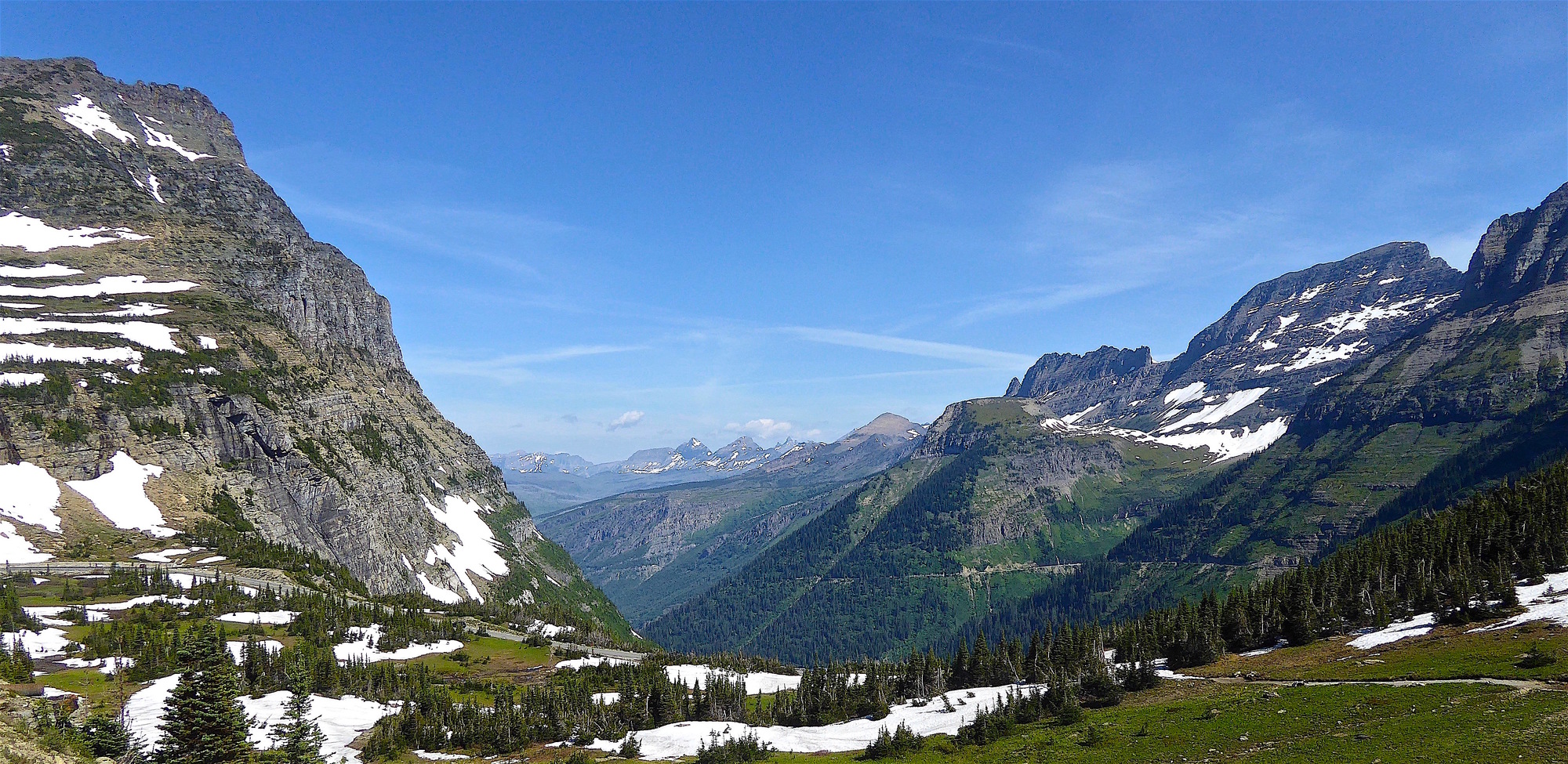
With the road surface in good condition and the grade a manageable 5-6%, I rode most of the way to the top in my 3rd and 4th gears. Above the treeline, I could see the road ahead as a line against the mountainside:

I made good time, reaching the Visitor Centre at Logan Pass in just over 2 1/2 hours. There was a clutch of West-to-East cyclists in the parking lot. Some were headed to Minnesota, others all the way to Bar Harbor, Maine. Hearing that I would be heading to Washington Pass, two young guys told me of being caught in bad weather on its eastern slopes in mid-June. Facing wind-driven cold rain mixed with snow (!!) they were relieved to find shelter in a campground.
These were the first touring cyclists I'd seen since leaving the Red Deer Riders at Saskatchewan Crossing ages ago on the Icefields Parkway. They were a congenial bunch, happy to meet a fellow traveller, and a Canajan at that. One had nice words for my bike: “Oooh—is that a Rohloff hub? Never even seen one of those. What’s it like?” And, "Wow! Love those alloy fenders! Where'dja get 'em?" She was tickled to hear that they'd come all the way from Maryland, home of Velo Orange.
I wished them safe journeys, and started my descent about 10 AM. The sign at the summit was clear enough about our elevation, although the backdrop wasn't a patch on Highwood Pass:

The western slope of Logan Pass is quite a bit longer than the eastern side: from the pass to the campground at Apgar, at the southwestern tip of Lake McDonald (the counterpart of Lake St. Mary) is 48 kms. The steep descent to Lake McDonald Lodge, at the northern end of the lake, is 34 kms. The long descent requires concentration--happily, I was in the inner lane, close to the mountainside--and frequent braking. There were many more cars than I had seen on my climb, and I was thankful that their drivers were considerate.
The western slope of the Great Divide offers spectacular beauty on a grand scale. I had seen it several years earlier from a car at sunset, driving down into darkness in the valleys. On a late morning in mid-summer, the mountains were awash in brilliant sunshine. If the week's ride from Jasper to Longview was the most prolonged stretch of natural beauty in my tour, this day was the most concentrated. The sunshine no doubt played its part in my judgment :), but I still feel that my photos don't do justice to the intensity of the colours or the depths of the gorges:
| Heart | 1 | Comment | 0 | Link |


| Heart | 1 | Comment | 0 | Link |


Stops for photos allowed my brakes to catch their breath and cool down, while I drank in the views. And eventually, we did reach the bottom of the valley:

| Heart | 1 | Comment | 0 | Link |
I reached McDonald Lodge after only 90 minutes, and enjoyed a hearty pasta lunch. A little further along the road, I stopped for three hours at Sprague Campground -- the narrow road on the western side of the lake is closed to bikes between 11 and 4, because of the volume of motor traffic. I took advantage of the enforced break to recheck my estimated times and distances for the coming two weeks, write some postcards, and do a bit of laundry. Domestic chores attended to, I reached Apgar Campground about 4:30, and found myself a hiker-biker site for the princely sum of $5 :)
Apgar village holds some attractions for cyclists. Lake McDonald is a good spot for a late-afternoon immersion--not for swimming, though, as it hadn't warmed up since my last visit 7 years earlier--and an espresso-and-ice-cream makes an excellent chaser.
The ride across Logan Pass had turned out to be an easy day, as I covered the 85 kms in a little over 4 hours. On the long and rapid descent, though, more than once I found myself saying, "Glad I'm not climbing this!" I made an early night of it to allow an early-ish start the next day. I wanted to stop in Columbia Falls to stock up at Smiths Supermarket--highly recommended by a cyclist atop Logan Pass--and in Whitefish, to visit the Amtrak office and Glacier Cyclery.
Today's ride: 137 km (85 miles)
Total: 975 km (605 miles)
| Rate this entry's writing | Heart | 3 |
| Comment on this entry | Comment | 0 |