May 29, 2017
Moab
A brief writeup today, because the wifi at our motel in Moab is excruciatingly slow. The day started out with a 12 mile stretch on another old, beaten up highway - its labeled Frontage Road on the map, but it's essentially abandoned. It looks to me like it may have been part of Old State Road 24 that we biked on coming into Green River yesterday - it feels about the same age and condition, and may have been abandoned with the completion of the freeway.
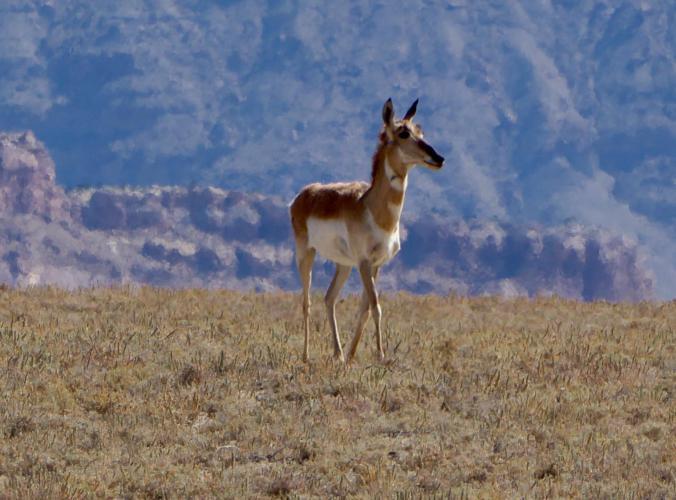
Riding it was similar too - it varies from intact but crumbling pavement and a manageable gravel-dirt mix. It's also quite beautiful, paralleling the Book Cliffs and low-profile clay hills that front them. Best of all, we saw three Antelope at fairly close range.

| Heart | 0 | Comment | 0 | Link |
| Heart | 0 | Comment | 0 | Link |


| Heart | 0 | Comment | 0 | Link |

The road ends at a freeway overpass and access ramp. Seeing no good alternative, we rode the freeway to Crescent Junction, at the intersection with Highway 191. Not too bad - good, smooth shoulder, safe, but noisy and boring. Except for a few prairie dogs we passed along the way.

| Heart | 0 | Comment | 0 | Link |
There is a market/gas station at Crescent Junction, and we planned to use it for our lunch break. They ordinarily stock premade sandwiches, but they were all sold out along with much of their other stock. They've been cleaned out by Memorial Day weekend travelers. We found enough to see us through though, and snacked in the shade outside - it's quite hot today - before heading on.
Highway 191 stinks. Most of the way it is a two lane highway with a too-narrow shoulder and too much traffic. Riding it is a heads down, white knuckle affair, with no slack to look around. At times it opens up, with an extra lane and a wide shoulder, but then it shrinks back again. Maybe they're upgrading it section at a time? We were very relieved when we finally arrived at the start of the bike path that runs from the Canyonlands turnoff to Moab, 12 miles away.

| Heart | 0 | Comment | 0 | Link |

| Heart | 0 | Comment | 0 | Link |

| Heart | 0 | Comment | 0 | Link |

The bike path is great. It's of course a relief to be off the highway, but it's also a highly enjoyable ride. We'll be on it again tomorrow, when we come back out for the ride to Dead Horse Point. Maybe I'll say more about it then. Or maybe you'll just have to look at the photos and use your imagination.

| Heart | 0 | Comment | 0 | Link |


I got my second flat of the trip about five miles from the hotel, which was no fun. It was over ninety degrees, there was no shade for miles, so I sat on my coat on the blistering pavement. Good times.

| Heart | 0 | Comment | 0 | Link |

| Heart | 0 | Comment | 0 | Link |

Tonight we're checked into a motel in Moab for four nights, for a series of day rides. We're looking forward to a few days of not packing up in the morning and not riding with all of our gear. Our first outing is to Dead Horse Point. To prepare ourselves, we went to Moab Brewery for dinner and I downed a pair of Dead Guy Ambers. I'm all set.
Elevation gain: today, 1,400'; for the tour, 34,600'.

Today's ride: 52 miles (84 km)
Total: 578 miles (930 km)
| Rate this entry's writing | Heart | 0 |
| Comment on this entry | Comment | 0 |