May 23, 2017
Bryce Canyon
Today's short ride to Bryce Canyon almost qualifies as a rest day - or at least as much of one as we'll get on this tour. Our short ride neatly splits into four nearly equal segments, making it easy for me to describe to Rachael over breakfast:- 7 flat miles south along the Sevier River; a gradual seven mile climb up to the top of the plateau, mostly through Red Canyon; a seven mile very slight drop along the top of the plateau; a six mile very gradual rise into the national park.
All that is fine and interesting of course, but what Rachael mostly wants to discuss over breakfast is food - not so much the food we're eating now, which is fine but basic cafe breakfast fare - food for lunch, food for dinner, food for the day after. We're both pretty serious planners, but plan on different themes - itineraries versus meals.
It's quite cool this morning, so we loaf around a bit and hit the road about 9:30. Conditions are beautiful again, perfect for cycling. I don't want to jinx ourselves, but we have been having exceptional luck with weather since we arrived. We've heard this over and over - if we had been a week or so earlier, it would have been much different - very stormy and wintery.
The ride south along the Sevier River on Highway 89 is beautiful - I think this section of the Sevier must be one of the prettiest valleys of the old west. Traffic isn't bad on the highway, and the wife, smooth shoulder makes it easy to tune out and appreciate the setting.

| Heart | 0 | Comment | 0 | Link |

| Heart | 0 | Comment | 0 | Link |
At the junction we turn east on highway 12 and start climbing away from the Sevier. We'll follow this road for the next four days, to its end at Hanksville. Passing through or past Bryce Canyon, Kodachrome Basin, Escalante and Capitol Reef, Highway 12 has a reputation as one of the most scenic roads in the country. It has been a dream of mine to bike it for thirty years, when I was planning for my first Utah tour and it made the short list but not the final cut. This is in some ways a frustrating region to plan a tour through, because there are so many dramatic destinations you'd like to include.
The two lane highway carries quite a bit of traffic, at least as far as the turnoff to Bryce. The shoulder is decent, but the traffic is definitely a distraction - Rachael was starting to complain about the exhaust fumes when we reached the entrance to Red Canyon, two miles up from the river. After that, the entire rest of the day's ride was on a beautiful paved bike path. The remainder of the ride was quiet and beautiful.
Red Canyon and its striking red cliffs is a minor attraction in its own right. The bike path goes through the heart of it for about seven miles. Here's Rachael's" class="redactor-linkify-object">https://onedrive.live.com/?aut... video of the ride through Red Canyon.
Leaving the canyon, the next five or six miles are through open meadow and range land, until we reach the turnoff to the national park. As we get closer it becomes steadily more commercial, with the roadside lined with RV campgrounds, motels, fast food joints and so on. This is all so different than when I first came this way, on a side trip to Bryce before continuing south to Zion - then, I think none of this existed other than Ruby's Inn.
Shortly before reaching the park, Rachael spotted a bakery/deli so we stopped in for lunch, enjoying sandwiches and drinks sitting at a bench in the sun. Two miles later, we arrived at the park entrance.
The entrance fee to bikers is $15/person; but for us, zero. My national park senior pass, which set me back a big $10, is one of the best investments I've made. If you're of age and don't have your own, snap one up fast - there are apparently plans to jack the price up significantly any day now.


| Heart | 0 | Comment | 0 | Link |

| Heart | 0 | Comment | 0 | Link |
Bryce Canyon Lodge didnt seem like they get many bike tourists. They didn't really want the bikes in the room, and weren't sure what to do with them. They finally just wheeled them behind the reception desk counter and worked around them during our stay, which worked fine for us but must have been awkward for them.
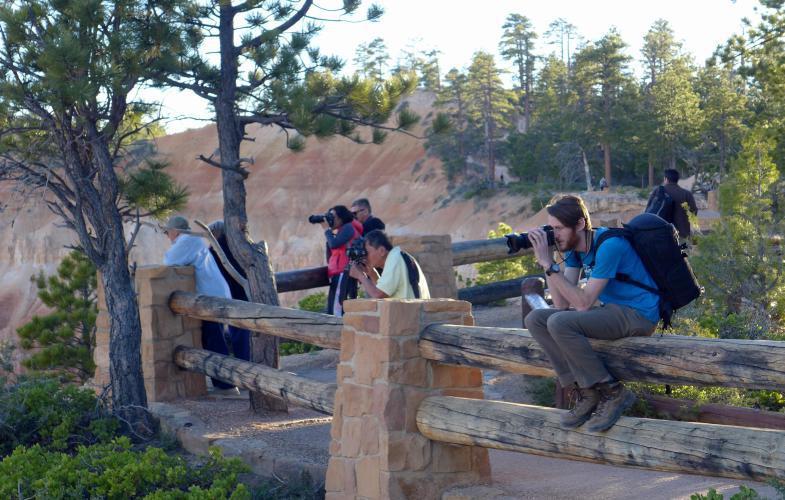
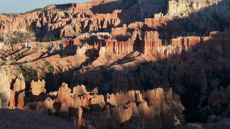
I'm a bit behind on the journal, so I'm not going to say a lot about our stay, other than that it was phenomenal. We spent the afternoon on a loop walk through the amphitheater had a delicious dinner at the lodge, and went out at sundown to watch the shadows ithlight the hoodoos. One of the most magical places we've stayed, even with the crowds.
Elevation gain: today, 2,700'; for the tour, 17,600'.

| Heart | 0 | Comment | 0 | Link |

| Heart | 0 | Comment | 0 | Link |

| Heart | 0 | Comment | 0 | Link |


| Heart | 0 | Comment | 0 | Link |

| Heart | 0 | Comment | 0 | Link |

| Heart | 0 | Comment | 0 | Link |


| Heart | 0 | Comment | 0 | Link |

Today's ride: 27 miles (43 km)
Total: 237 miles (381 km)
| Rate this entry's writing | Heart | 1 |
| Comment on this entry | Comment | 0 |