September 9, 2019
Day 2: Coeur d'Alene to Harrison. Lake Coeur d'Alene
On the road at 9:40 after breakfast at the motel. Overcast, 56F (13C), and threatening to rain. I wasn't in a hurry to get moving. The day starts with a mile of on-street bike lanes, then 7 easy miles on the Centennial Trail with Lake Coeur d'Alene drive to the left and lakefront parks to the right.

The sky threatened to rain all day. Intermittent drizzle during the morning, intermittent rain during the afternoon. Not as relentlessly wet as yesterday but colder, with temperature in the 50's all day.

The trail has a sign explaining the history of steam-powered boats on the lake. Commercial steamer service began in 1884. Steamers were the primary mode of transportation for cargo and people until the 1930's when roads were built.
The Centennial Trail has a good view of the I-90 Centennial Bridge 300 feet above. Very high and graceful, with 520 foot long center spans.

After 7 miles the Centennial Trail ends with a short but steep dead-end climb to Higgins Point. It has a large picnic area but I was the only one there on a cold drizzly Monday morning.

| Heart | 0 | Comment | 0 | Link |

To continue around the lake I backtracked 1/2 mile from Higgins Point to an overpass that allows me to cross under I-90 and go 1/2 mile up a hill on an unsigned route with surfaces ranging from sand-covered pavement to rocky single-track. Then a barely visible trail drops steeply to an unpaved residential street which connects to paved Yellowstone Trail road.

Unfortunately the pavement only lasted 1/2 mile before I began a gravel 250 foot climb, in the rain. I expected the climb but not the gravel. The landscape is mostly pine forest with only occasional glimpses of the lake.

| Heart | 0 | Comment | 0 | Link |
Rough pavement resumed at the summit. I suspect that Yellowstone Trail is the original wagon road.


| Heart | 1 | Comment | 0 | Link |
Yellowstone Trail descends to cross under I-90, then connects to ID 97 which has good pavement and stays close to the lake.

This area is all upscale vacation homes. I saw no evidence of poverty and only one token abandoned building.

| Heart | 0 | Comment | 0 | Link |
ID 97 offers panoramic lake views for a couple miles before climbing the first of two 400 foot hills. The busy road and homes on steep pine forested slopes remind me of Lake Tahoe.

| Heart | 0 | Comment | 0 | Link |
The view from the summit was spectacular but somewhat hazy because of light rain.

Hutton's General Store appeared at just the right time, at the halfway point of today's route when I needed a break from the rain. There were no other stores on today's route. Thousands of vacation homes but no gas stations or stores.

| Heart | 0 | Comment | 0 | Link |

| Heart | 1 | Comment | 0 | Link |
The east shore of Lake Coeur d'Alene is much more populated than I expected. Thousands of vacation homes. The highway has heavy traffic from residents, contractors, and a few tourists. Many sports cars drove by at alarming speed on the relentlessly winding curves. I saw no motorcycles, probably because it was too wet. No other bicycles, either.

| Heart | 0 | Comment | 0 | Link |

| Heart | 1 | Comment | 0 | Link |
The mountains are National Forest but the area near the lake is private land. I saw many private homeowner's association parks, but only one public park. At the public park I took a long stop under a roof to wait out a spell of heavy rain.

| Heart | 0 | Comment | 0 | Link |
Houses thinned out as I got to the south end of lake Coeur d'Alene. Now it's very far from the city of Coeur d'Alene. ID 62 climbs another 400 foot hill just before Harrison. A sign at the summit says 6% downgrade next 1.5 miles. Fortunately the rain stopped a few minutes before I arrived in Harrison. I wasn't soaking wet when I arrived.
This tour follows the two major streams that feed lake Coeur d' Alene, the Coeur d'Alene river and the St. Joe river. This tour also follows the outlet stream, the Spokane river, but only down to Spokane and not all the way to the Columbia river.
A mile before Harrison I crossed the mouth of the Coeur d'Alene river which is channelized to be navigable but surrounded by miles of wetlands. I will go up the river tomorrow on the Trail of the Coeur d'Alenes.

| Heart | 0 | Comment | 0 | Link |
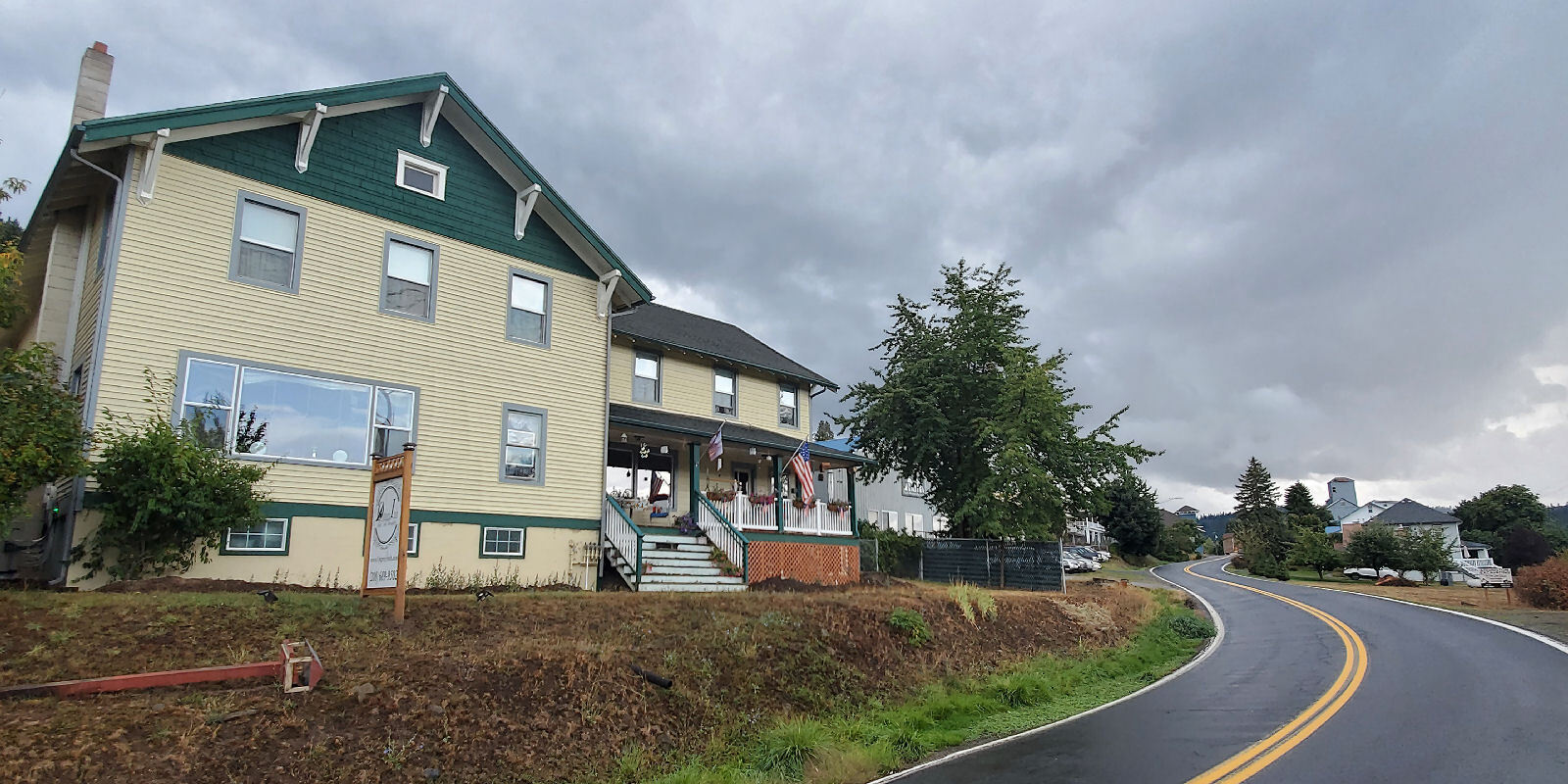
I arrived in Harrison at 4:40 PM just as it started to rain again. I rushed into the Osprey Inn Bed & Breakfast to get my reserved room. It was the last available room in town when I booked it a month ago. 3 windows face the lake but have almost no view of the water because of trees. $190. Most expensive night of the trip by far, but necessary to make this route work. I expect a gourmet breakfast. The bike goes in the garage with all the other guest's bikes. Osprey Inn is a Craftsman-style structure built in 1915 as a boarding house for lumber mill laborers.
| Heart | 0 | Comment | 0 | Link |

After the rain stopped I walked around the little town of Harrison. It has many interesting historic buildings. In 1920 it was a logging boom town with 1200 people. Now it's a tourist town with 217 residents.


| Heart | 0 | Comment | 0 | Link |

| Heart | 0 | Comment | 0 | Link |
I had dinner at the only restaurant in town that was open, One Shot Charlie's. It was quite busy. It appeared that all of the customers were here for bicycling. Before dinner I visited old Internet friends in their motel room, meeting them in person for the first time. Their suite at Harrison Inn has an unobstructed view of the lake. Judging from the bicycles all around it seemed that all of the guests at Harrison Inn are on multi-day bike trips.
I enjoyed the conversation with Spoon, Harpo, Oren, and Nellie. We are going opposite directions so I won't see them again during this trip. They are all over 70 years old and still doing bike tours! They're from Texas, Arkansas, and Missouri. Note that they are wearing jackets and the Oregon guy isn't.

| Heart | 1 | Comment | 2 | Link |
1 year ago
1 year ago
Today had the most climbing of any day of the tour. Today had a high of 59F (15C), the coldest day of the tour. Add frequent rain and it was the most difficult day of an otherwise easy tour.
2 miles unpaved today.
Distance: 41.1 mi. (65.8 km)
Average Speed: 8.7 mph (13.9 km/h)
Ascent/Descent: +2520/-2509 ft. (+768/-765 m)
Today's ride: 41 miles (66 km)
Total: 90 miles (145 km)
| Rate this entry's writing | Heart | 1 |
| Comment on this entry | Comment | 0 |