April 18, 1991
Moki Dugway to Sand Island
I'm sitting in a Mexican Hat cafe overlooking the San Juan River, enjoying an early dinner of beef stew and fry bread. While waiting to be served, I surveyed the post cards on display and took pleasure in seeing that I recognized most of the places featured on them. It feels like I've really seen and experienced this part of the world now.
It is about three in the afternoon and I've already covered a lot of ground, thanks to favorable winds. My first ten miles were a fairly leisurely cruise across Cedar Mesa, leading up to Moki Dugway. I feel rewarded for my good judgement in retiring early last night, for the miles are much more enjoyable this morning.
Biking down the Dugway is quite an experience. From above, it offers an impressive overview of the San Juan basin and across into Navajo country. Looking virtually straight down, the highway continues far below. The sign says it drops 1100' in three miles. It is hard to see where there is even room for a road on this cliff. The ride down is not terribly unnerving, though it requires constant concentration - the road surface is sand and gravel, the bike is slightly skittish, and the unprotected edge of the road drops straight down.

| Heart | 2 | Comment | 0 | Link |
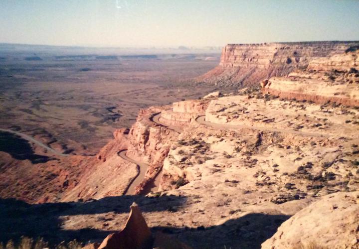
Once at the bottom, everything is different - it is dry and desert-like, I'm surrounded by cliffs, and it's warm. Looking back from a distance, it is remarkable that I can't tell where the road comes down - that section of the cliff face looks no less precipitous than any other.
The remaining twelve miles to Mexican Hat come easily. It's all downhill, winds are light and variable, and the ride is highlighted by a startled coyote which races off into the sage when he sees me approaching, and also by several mountain bluebirds that add a surprising bit of color.
I had breakfast at a curious cafe - a former dance hall/bar in the process of renovation. The proprietress (who is still in curlers) said they could no longer afford the insurance to operate as a bar, now that restaurants can be sued and held liable for alcohol related injuries. For breakfast I had a huesvos ranchero concoction - it was good, but no sausage and eggs.

| Heart | 1 | Comment | 0 | Link |


| Heart | 1 | Comment | 0 | Link |

After filling up, I stowed most of my gear at the cafe and prepared for a round trip excursion to Monument Valley, twenty miles to the southwest. Before leaving though I stopped in at a store to pick up milk, juice and sunscreen, and then visited the post office to dispatch post cards. I chatted awhile with the postmistress, who has been here six years and wanted to get back to Grand Junction someday. She left when the Exxon plant shut down, creating massive layoffs. She said it affected her work, as a nurses aide in a neurology unit - because people were too broke to drive their cars so there were fewer head injuries!
The ride to Monument Valley featured:
- a chat with a young Navaho man selling wares at a vista pulll-off. He's been to college to study landscape architecture, but there's no demand for that type of work here. He offered to give me a ride back to town in his pickup truck if I came back by late enough in the day.
- the remains of an ugly car accident on an innocuous lookingstretch of road. There were surely fatalities involved, I'd think. The emergency crews were still cleaning up the scene when I returned about two hours later.
- great scenery!
- fresh Navaho fried bread, prepared at a tourist stand in Monument Valley.
- long, steep hills and descents.

| Heart | 1 | Comment | 1 | Link |


| Heart | 1 | Comment | 0 | Link |
Back in Mexican Hat again, I stopped back at the cafe for food; then, after picking up my gear and a beer I started east for Bluff, twenty four miles away. About eight miles east of Hat I stopped at the access to the Valley of the Gods to enjoy my beer next to a shallow, alkaline creek. The white crust rimming the water was pretty next to the greens, reds and browns of the earth and desert vegetation.
Eight more miles of road brought me to a strange two mile stretch of road which was heavily coated with pinkish red silt. The highway here was sandwiched between high sandstone cliffs. Perhaps the silt blows off the top and becomes entrapped?
Five more miles, and I arrive at Sand Island campground, where I stop for the night. This is perfect - only two miles to breakfast in Bluff, and well positioned for the long push to Cortez tomorrow. My stay at the campground was unusually interesting. It is a low-profile, not too developed spot - little in the way of accommodations, but also little intrusion on the serenity of the setting next to the San Juan River. Its major distinction is the presence of some Anasazi petroglyphs. Except for a fairly small amount of graffiti they are quite well preserved - they featured, among other things, a herd of big horned sheep and Kokapelli, the humpbacked flute player who was presumably a fertility symbol to the Anasazi.
After pitching my tent I walked over to the river, where I sat watching the flow of the grey-green water and writing in my journal until dark.


Today's ride: 85 miles (137 km)
Total: 490 miles (789 km)
| Rate this entry's writing | Heart | 1 |
| Comment on this entry | Comment | 0 |