April 2, 2011
Day 9: To Furnace Creek via Badwater
I am very well rested and extremely bored after sitting two days in Shoshone. Today I go to Furnace Creek no matter what. The weather forecast calls for a high in the upper 90's (37C) with a 40 mph tailwind in the afternoon. The forecast was correct about the wind, but Death Valley turned out to be mostly cloudy so the high was only in the low 90's (34C).
I knew it will be a long day, so I was on the road before 8 AM. Very early for me. The day starts with a gentle 1600 foot (485 m) climb on highway 178 to 3315-foot (1005 m) Salsbury pass. The sun was behind me, giving an excellent view of the Black mountains.

| Heart | 0 | Comment | 0 | Link |


| Heart | 0 | Comment | 0 | Link |

| Heart | 1 | Comment | 0 | Link |
The descent from Salsbury pass had the best wildflowers of the trip. It was the only place where I saw large splashes of color from a distance.

| Heart | 1 | Comment | 0 | Link |
Next is a steep 250-foot climb to 1290-foot Jubilee pass. It's a trivial climb when going west, but much bigger when climbing out of Death Valley. The sky became increasingly cloudy during the descent from Jubilee pass. Fine with me because it won't be quite as hot in Death Valley.
I stopped at Ashford Mill to look around. The site has ruins of one building and ruins of the mill that processed gold ore from a nearby mine. It's at sea level with a great view of the southern Panamint mountains. The wind was nearly calm when I arrived, but a south wind was building by the time I departed.

| Heart | 1 | Comment | 0 | Link |

| Heart | 2 | Comment | 0 | Link |

| Heart | 0 | Comment | 0 | Link |
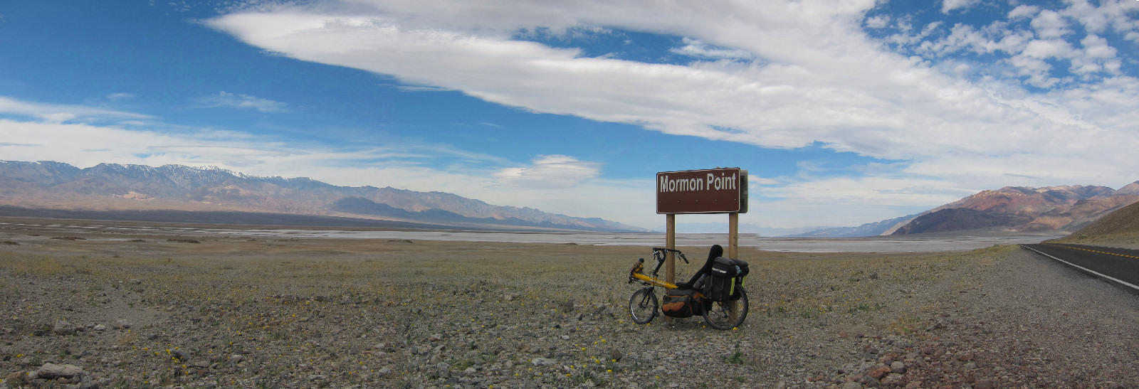
Mormon Point has a panoramic view at the southern gateway to the lowest part of the valley. Well below sea level, but still 20 miles from Badwater. Thanks to the tailwind I cruised 20+ mph most of the way to Badwater.
| Heart | 1 | Comment | 0 | Link |

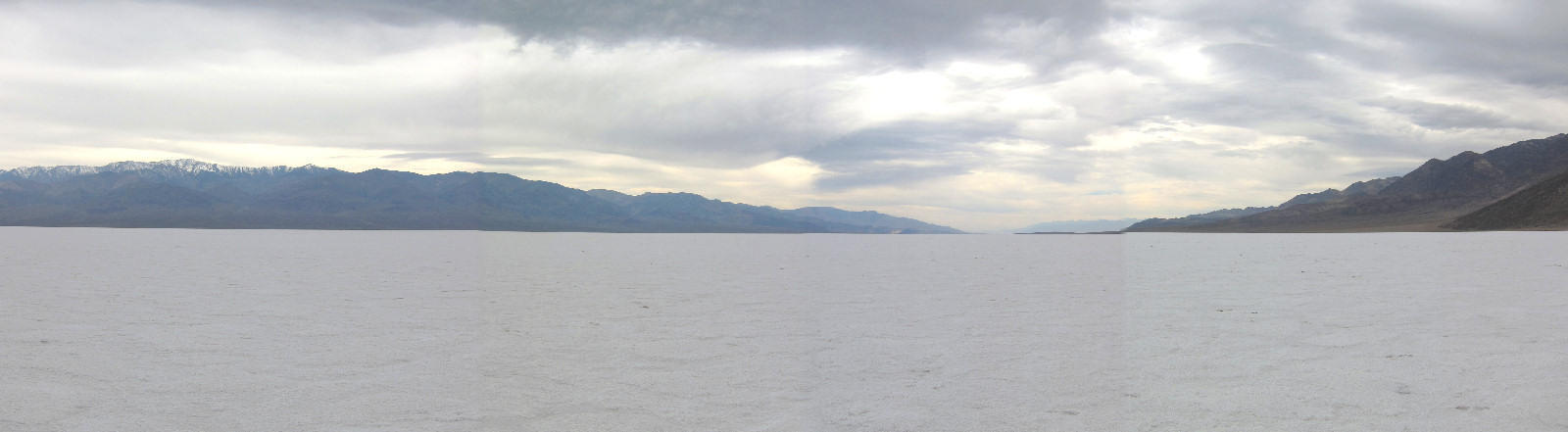
I took a long stop at Badwater along with hundreds of other tourists who arrived in air-conditioned cars. The temperature was 90F (32C). After posing for a picture at the sign I walked out onto the salt playa. I had to walk a mile out into the salt before it was thick and untrammeled enough to make good photos. There was still another 5 miles (8 km) of salt between me and the Panamint mountains.
Wikipedia: Situated within the Mojave Desert, Death Valley features the lowest, driest, and hottest locations in North America. Badwater is at 282 feet (86 m) below sea level, yet only 84.6 miles (136 km) from Mount Whitney, the highest point in the contiguous United States with an elevation of 14,505 feet (4,421 m). Death Valley holds the record for the highest reliably reported temperature in the Western hemisphere, 134F (56.7C) at Furnace Creek on July 10, 1913-just short of the world record, 136F (57.8C) in Al 'Aziziyah, Libya, on September 13, 1922.
September 2012 Update: The World Meteorological Organization invalidated the 1922 Libyan record because of the combination of a poor weather instrument, bad location for accurate readings, and an inexperienced record-keeper. Consequently, Death Valley is now officially regarded to be the hottest place on the planet.
The vertical relief is hard to comprehend, standing at 282 feet (85 m) below sea level with a view of 11,049 foot (3348 m) Telescope Peak. It's the tallest vertical escarpment in the U.S. Average annual precipitation is only 1.6 inches (4 cm) per year.

| Heart | 0 | Comment | 0 | Link |

| Heart | 0 | Comment | 0 | Link |

| Heart | 0 | Comment | 0 | Link |
| Heart | 1 | Comment | 0 | Link |
Interpretive signs describe the geology of Death Valley. The valley is located where tectonic plates are separating. The mountains are rising at the same time the valley is sinking. The valley floor is filled with a 9000 foot (2700 m) deep layer of debris that has washed and blown down from the mountains over the ages. Without this debris Death Valley would be 9000 feet below sea level!
I was making such good time with the strong tailwind that I decided to make an unplanned side trip to the Natural Bridge north of Badwater. The 1.5 mile gravel road to the Natural Bridge trailhead is extremely steep and rough. I pushed the bike half a mile because I didn't want to reduce tire pressure on such a short gravel road. After climbing 600 feet (182 m) on the road the trail climbs another 200 feet (60 m) up a wash to the Natural Bridge. The sky became mostly sunny as I was leaving the Natural Bridge.


| Heart | 0 | Comment | 0 | Link |
Farther north I debated whether or not to ride the Artist Drive today. It's best in the late afternoon, but I wasn't sure I could get to the main sights before sunset. I decided to go for it. The 1-lane 1-way paved loop road climbs 1200 feet (365 m), descends, then climbs another 300 feet (90 m). It had already been a long day by then, so I was exhausted by the time I got to the Artist's Palette overlook. I was disappointed to arrive 2 minutes after the sun dipped behind a cloud.


| Heart | 1 | Comment | 0 | Link |
The views were good, but would have been much better if I arrived a few minutes earlier. As predicted the wind was 40 mph (64 km/h) late in the afternoon, with much blowing sand. I had to remove the visor from my helmet because the wind kept ripping it loose.

It was well past sunset when I arrived at Furnace Creek.

Once again I got an unshaded gravel campsite at the Texas Spring campground, but this time I paid for two nights. It was dark by the time I finished setting up the tent in a howling wind. Fortunately my tent stakes are tri-spoke aluminum extrusions that withstand being smashed into gravel. Most tents were roped to large rocks because their tubular stakes couldn't penetrate the gravel.
This was the warmest night of the tour. It was still 84F (29C) at 10 PM. Most everybody in the campground stayed up late waiting for the temperature to drop. The wind persisted all night, helping to make the temperature more tolerable. After 3 days in 90 degree temperatures I'm more adapted to the heat now.
Today was an epic day with huge distance, climbing, and hiking. I didn't plan to go to the Natural Bridge, and I planned to do the Artist Drive tomorrow. I'm exhausted, but tomorrow will be an easy rest day.
Distance: 86.6 mi. (138 km) ...longest day of the trip...
Climbing: 5871 ft. (1780 m) ...biggest daily climb of the trip...
Average Speed: 11.3 mph (18 km/h)
Maximum Speed: 39 mph (62 km/h)
Hiking: 3.5 mi. (5.6 km)
Today's ride: 87 miles (140 km)
Total: 346 miles (557 km)
| Rate this entry's writing | Heart | 1 |
| Comment on this entry | Comment | 0 |