July 18, 2018
Mount Robson
This morning had a leisurely start. We enjoyed sleeping in a bit, catching up after the last few days when we woke up early to beat the heat. We also enjoyed the ease of being in one place for a few days, eating breakfast at our cabin and leaving for a ride without packing up.
About 9, we’re on the road, continuing north on highway 5. It’s surprisingly quiet this morning, and a good ride - the highway has a generous, smooth shoulder and feels perfectly safe. It’s a pretty, partly cloudy morning that gives us a nice view of the mountains to the west -the Monashies, I believe.
There are two quiet side roads that are available for part of this distance. On one, we see a large deer down the road in front of us that melts back into the trees as we approach. On the other, we find road closure signs and a construction crew replacing railroad track and a crossing. We have to turn back, but the crew boss informs us that they should be done in about three hours - good news, because we’d like to come this way on our return ride.
In about ten miles we come to and cross the mighty Fraser River, one of the longest rivers in Canada and the longest in British Columbia.

| Heart | 3 | Comment | 1 | Link |

| Heart | 3 | Comment | 0 | Link |

Immediately after crossing the Frase our highway merges with Highway 16, the road from Prince George. From here the route takes a right turn and follows the Fraser River to Mount Robson, the Continental Divide at Yellowhead Pass, and to Jasper. We plan to ride this entire distance, in both directions, as three day rides. Today we’ll ride to Mount Robson and back; tomorrow, from Mount Robson to near Yellowhead Pass; and the following day, from the pass to Jasper, our next base camp for the tour.
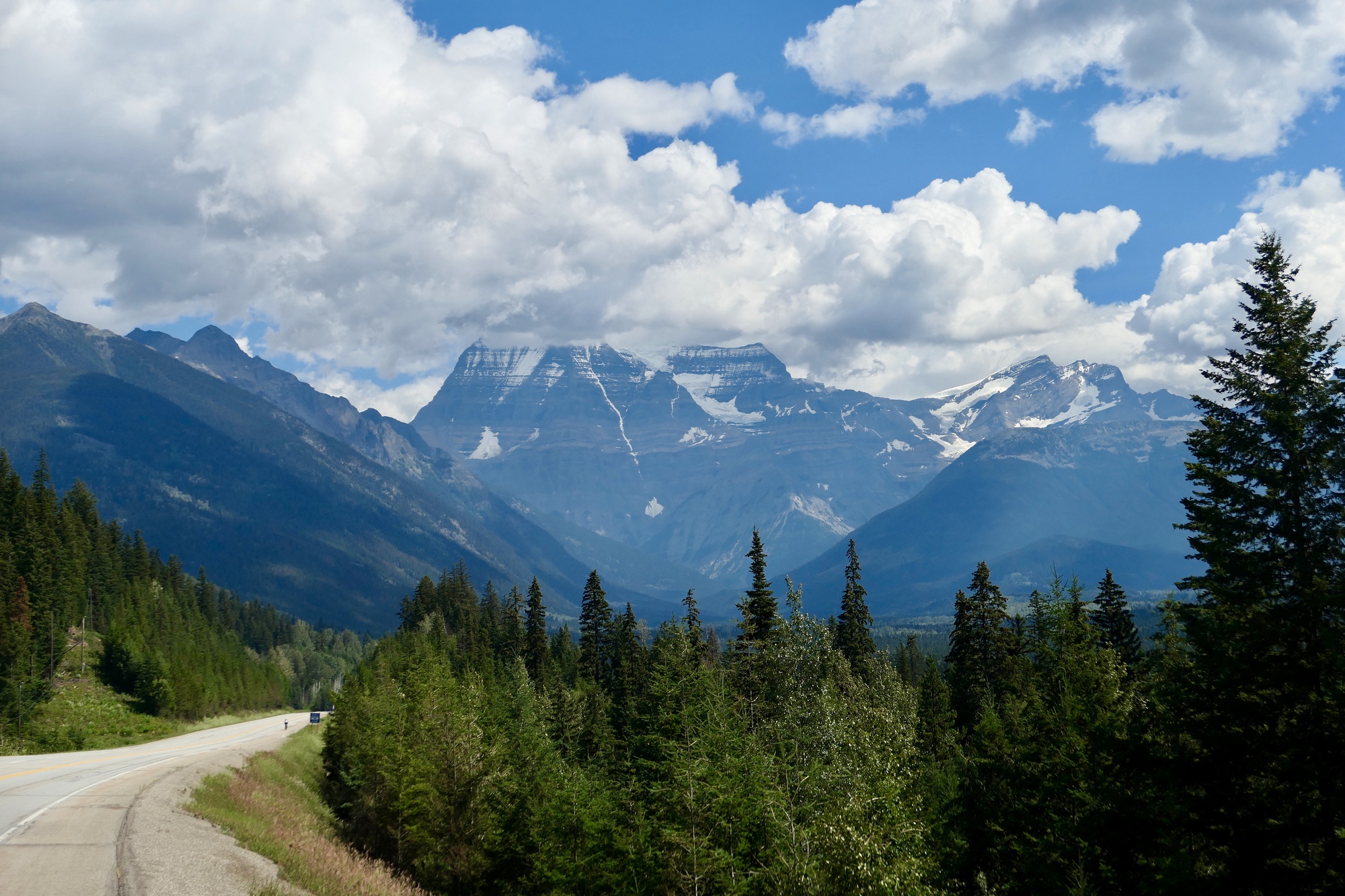
Mount Robson is a doubly distinguished peak. At an elevation of nearly thirteen thousand feet, it is the highest peak in the Canadian Rockies. And, it is the most prominent peak in the entire North American Rockies. Prominence is a measure of how distinctly a peak rises above its immediate surroundings; and Robson sure is prominent. It southwest face rises up nearly two vertical miles from the land at its base.
I’ve been here before: as I mentioned in the introduction to this journal, I biked from Prince George to Calgary back in 1987, in the summer before Rachael and I first met. I have a quite poor memory for many things, but I have a pretty fair one for places. As soon as we crossed the Fraser, I instantly recognized the road; and gradually many old memories came back as I biked along.
One of my strongest memories of that earlier tour is of my first view of Mount Robson, which stunned me at it towered above the Fraser Valley, its peak disappearing into an unbroken stratum of clouds. It was impossible to tell how far up it continued, and ever since I’ve longed for another chance to see the mountain, hopefully on a clearer day. Part of the reason we’re staying in Valemount for three nights is to improve our chance to get a good look at the mountain with less cloud cover. The great mountain is notorious for hiding its secrets behind the clouds.
Prominent though it is, we can’t see it yet. There are nearer significant ridges that block our view for a few miles as we bike east, stopping along the way for a short hike down to impressive Rearguard Falls. This is another spot I recognize from the earlier tour. The access has been much improved and modernized since then, to prevent erosion and probably careless spectators. Back then you could see the Falls from below and look in amazement at bright red sockeye hurling themselves against the falls. Now you see it only from above from a safely fenced viewing platform.

| Heart | 2 | Comment | 0 | Link |

| Heart | 4 | Comment | 0 | Link |

About a mile from the Falls we come to Terry Fox Provincial Park, and immediately after Mount Robson comes into view for the first time. For the next five miles the mountain will remain in view, dead ahead of us rising above the long, straight highway. I think there must be no better way to come to the mountain than from this direction, by bicycle. From the minute you first see it, it dominates the horizon; and it is breathtaking biking dead on at it, watching it gradually grow even greater before you, and it’s details and colors becoming more distinct.
We’re getting quite a good look at it today. The cloud base is well up the mountain. We can’t see it all, but what we can see is awe-inspiring. It’s as great as I remembered. Greater, really, because I had completely forgotten that it was steadily visible ahead on the road like this.
| Heart | 4 | Comment | 0 | Link |

| Heart | 4 | Comment | 4 | Link |
4 years ago
4 years ago
, cool and safe. Respectively Keith
4 years ago


| Heart | 1 | Comment | 0 | Link |
We arrive at the park visitor center in about a half hour. It’s taken so long because I keep stopping to look and photograph the mountain as it grows larger and more distinct. And, as we near it the clouds seem to have lifted a bit and to even be breaking up a bit. By the time we arrive, it’s a ight epaulette is fully exposed, something I couldn’t see three decades ago.
We sit in the park and enjoy our brought lunches for about a half hour, supplementing them with an ice cream sandwich and milk from the visitor center. While we’re there, Rachael gets into an extendee conversation with a young man who hikes this country, and is armed to protect himself against a bear attack. Rachael starts getting anxious about the risk of a bear attack, but is heartened when another hiker, at the end of his vacation, gives her his can of bear spray that he no longer needs. Hopefully it won’t be needed and she can pass it on to someone else later in our tour.
While we’re sitting, a small miracle occurs and the clouds continue parting. I’m thrilled to get a nearly complete view of the mountain. Much more than I’d hoped for.


When we leave the park and turn back west, we receive a surprise: the wind has picked up significantly, and is blowing into our faces. It’s not bad - about 10 mph or so - but strong enough to get our attention.
We take a longer route on the way home, taking a detour west down Old Tete Jaume Road for several miles until the pavement gives out. From purely a riding perspective, these are probably the nicest miles of the day: quiet, calm, rustic, pleasant.
When we return from this detour we turn south on Blackman Road, the road that was blocked by construction work five hours earlier. It’s about four miles to that spot, and the whole way we’re hoping they’re done and we won’t have to backtrack four miles on a day that’s now starting to warm up seriously. We’re ready to get off the bikes and slip into someplace cool.
They’re not done. We’re advised to turn back. We look glum, and ask if we can just walk down the track a ways and cross over beyond the construction site. Our man looks doubtful, then walks to discuss the situation with his colleagues. They discuss it for a minute, and then beckon us to come forward and cross the tracks whik they pause work for a minute. One man even chivalrously offers to lift Rachael’s bike over the tracks for her.
Canadians are so Nice!


| Heart | 2 | Comment | 3 | Link |
5 years ago
5 years ago
5 years ago

| Heart | 3 | Comment | 0 | Link |

| Heart | 1 | Comment | 0 | Link |


Today's ride: 58 miles (93 km)
Total: 524 miles (843 km)
| Rate this entry's writing | Heart | 6 |
| Comment on this entry | Comment | 3 |
5 years ago
5 years ago