June 25, 2012
Langdale, Wrynose Pass & Duddon Valley
camp in woods
The staff at the Youth Hostel check their ledger to see who's arriving: a few school parties coming in buses, which means the car park won’t be too packed. Consequently they agree the car is OK while we go touring and I fib that we’ll be back in a day, knowing it’ll be a couple – maybe more.
The Youth Hostel is packed with school noisy children having breakfast. The three of us forked out around 30 quid each for the basic room, which seems a lot, and it's good to get away, pedaling first through town to find some stepping stones Patterson sketched.

The River Rothay isn’t much more than a stream, but it flows along quite high what with all the recent rain. The side road that traces it is lined with trees giving us a canopy to ride under and a few houses are here and there, but it's pretty quiet and much better than the main route.


We stop at a stone bride and take a few snaps, then soon after find the stones.


The water is flowing over them, whereas Patterson’s drawing has them protruding a foot or more out of the river.
To copy the sketch, I take Debbie’s lighter bike and step onto the first rock, then the second. Dave has my camera and I know roughly where to get to to recreate the image – it's near the opposite bank, but my feet are going to get wet, as the Rothay sweeps fast over the smooth stones and my SPD sandals are finding it hard to find any grip It takes a minute or so before mission is accomplished and I can carefully make my way back.
The A 593 weaves along beside the sweeping flank of some mountains down Langdale. The countryside is green, but the sky is grey and rain looks imminent.
We pause at a village shop and get a few snacks and I splash out on an OS map of the area: another eight quid goes out the window.

Stickle Tarn is up a valley side. It's a high lake way out of sight and only accessible via a steep and rocky footpath.
There are two pubs at the bottom of the walk and Dave decides to stay in one of them, keeping a look-out on the bikes while Debbie and I trek up the path, me lugging her bike for the photo that will hopefully mimic Patterson’s drawing. Hopefully.

It's hard to say how far it is or how long it’ll take. I say to Dave we’ll be an hour or so.
After 30 minutes, a pair of hikers coming down tell us we’ve be another hour or so to go and we decide to give up. The path is very steep. At timed I use my hands to get up. My guess is Patterson just drew a bike onto a postcard image.

| Heart | 1 | Comment | 0 | Link |
Still, it's a good experience, one which gives us elevated views of the surrounding landscape, with soft peaks forming the horizon and we make our way back down, bouncing the bike over the rocks.
Wrynose Pass stands in the way of the next valley. A single-track road that goes up it is one of the steepest in the UK and the pass’s unusual name is said to come from the 'pass of the stallion' – stallion referring to the fact that a strong horse was required to reach its top. Maybe granny gears will do. Maybe not.


The small strip of tarmac kicks up to reach Blea Tarn. It's hard work and we make our way up it slowly and at the crest the road dips down along the contours and in the near distance is the lake, looking calm. Dampness enveloped the landscape.
We zip along for a while, with just one or two cars passing by. A sign then points us right to Hardknott Pass and Wrynose Pass and shortly after another sign informs us of 30% inclines.
Water is in the air and the road is damp.


Not many people live in these parts. We only see a few stone farmhouses, each isolated and looking vacant, even though they're actually inhabited. The walls have lichen on them - a yellow colour.
It's a 25% climb up Wrynose and granny gears are not enough - I end up walking. Dave keeps going, spinning away, but Debbie falls back and joins me. This gives us a chance to savour the views, with the valley behind us being U-shaped and culminating in ridges devoid of trees or anything else above ankle height. The wind is at our backs and makes the only sound to be heard.


The three of us take in the view from the pass itself and take a few more snaps there, too.
Wrynose Bottom is different from the climb up and is more sheltered and the stream that runs down its center glistens in the faint sunshine, with breaks in the clouds giving the green landscape patches of brightness that travel along at speed, coming in our direction.
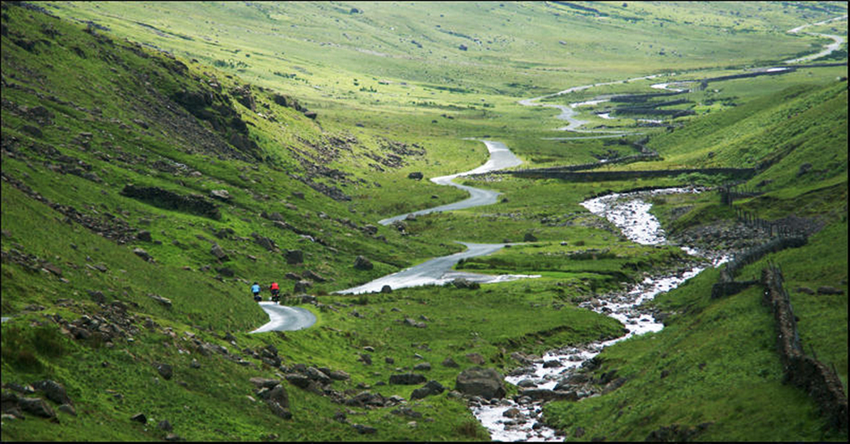

We eventually reach a small junction with Duddon Valley to the left and Hardknott Pass to the right. Tackling the 30% climb would be something, but I want to find the spot in the scenic valley that Patterson drew, so we set off for it.
The route is pretty flat and the back-wind pushes us along, nevertheless it takes us a while to locate the place Patterson sketched - a bendy section of the route which he viewed from the opposite direction.
After snapping it, we opt to press on as our stomachs are empty and it's late now and getting dark, and the temperature has dropped a little.


As luck would have it, we soon come across a pub serving food: The Newfield Inn. Inside it's very cosy and the menu isn’t a usual microwaved pub grub, but a selection of gourmet dishes.
I order a giant Yorkshire pudding and don't get disappointed. We each have a couple of decent pints of real ale - not ideal for tacking a steep climb that we find soon after leaving in the twilight of the day.
The sun dips toward the pass’s top – over Birker Fell - and we see it disappear, then see it again as we climb higher. The sky is a mix of warm tones, dramatic and splendid as sunsets can be.


Our eyes are peeled for a camping spot and while there's a lot of space, we want somewhere sheltered, so drop down the steep road to a village and wonder about pitching the tents in a field.
The problem is there are a few farm houses nearby, so we keep going and get to some woods a mile or so further. A muddy track leads into them and at its far end is an ideal spot - out of sight.
Today's ride: 60 km (37 miles)
Total: 3,717 km (2,308 miles)
| Rate this entry's writing | Heart | 3 |
| Comment on this entry | Comment | 0 |