April 1, 2017
Day Two
Heading off to War.
One of the problems King Alfred faced lay in the way his forces were organised. The Danes were essentially a professional occupying army, well trained and equipped, kept supplied by the population they had conquered. By contrast, while Saxon lords and landowners did have small personal forces of experienced men-at-arms, the main body of their army consisted of farmers and peasants. Poorly trained and armed, these men were tied to the land by the seasonal requirements of harvesting and animal husbandry. The Saxon forces couldn't sustain a prolonged campaign, and needed a short, decisive victory.
But such victories had been in short supply for the Saxons since the Danes had progressed from viking raids to conquest and permanent settlement. Constant attrition and defeat had led to many Saxons fleeing overseas to Gaul (France), and Alfred retreating to the marshes of the Somerset Levels. He badly needed to take the battle to the Danes so, carefully co-ordinating his forces, he arranged for them to rendezvous at a site called Egbert's Stone...
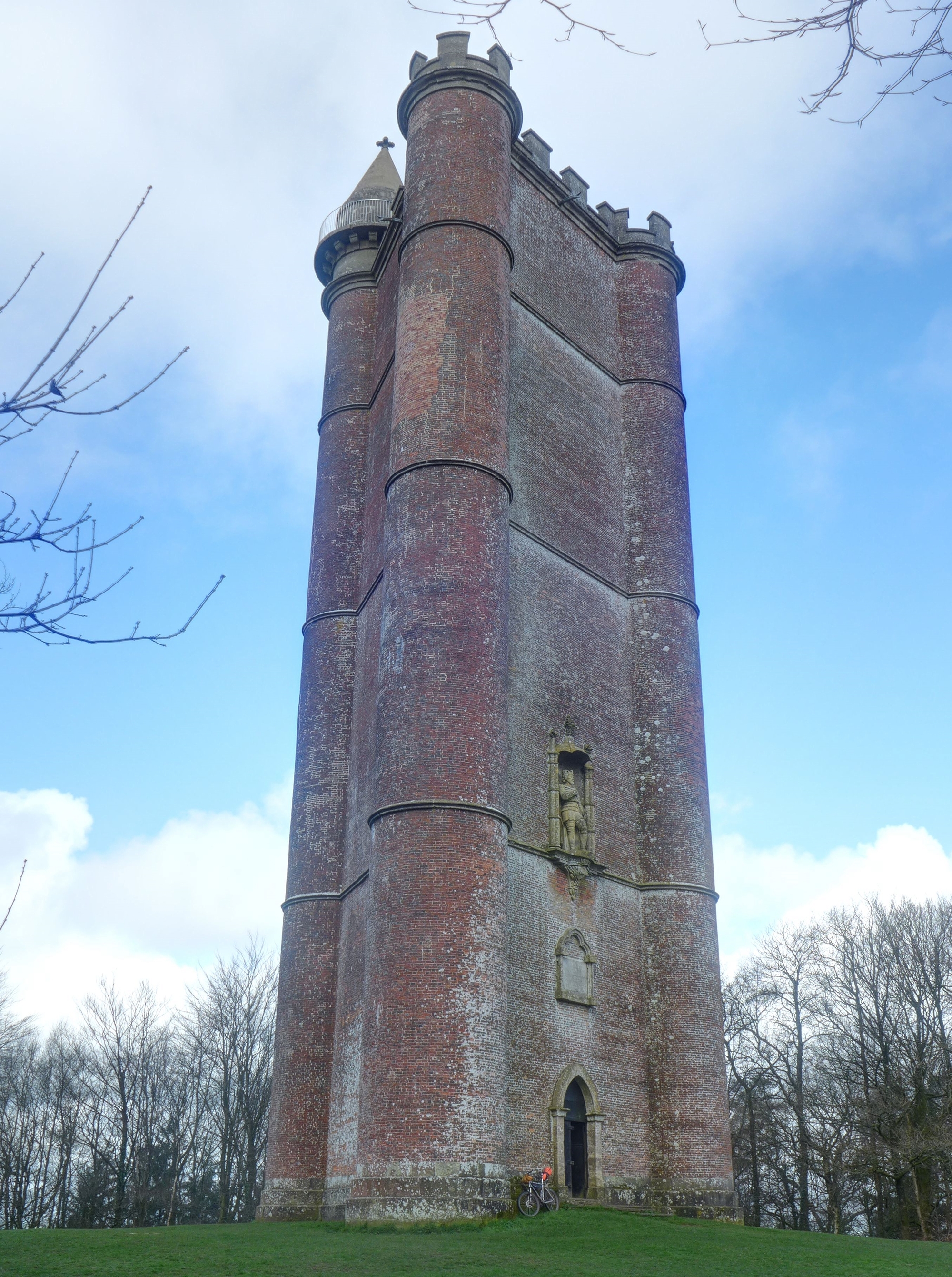
And that was my first point of call when I set off at 07:00 on a cool Saturday morning. I was on the mountain bike this time, loaded with gear for an overnighter. Minor roads and lanes took me through rural Somerset, before a final (and surprisingly steep) pull up to Alfred's Tower through pine woodland drenched in birdsong.
| Heart | 3 | Comment | 0 | Link |
There are several contenders for the location of Egbert's Stone, but Alfred's Tower, built in the mid-1700s, has possibly the strongest claim. It sits on a high ridge, with the Stourhead springs nearby to provide water in an otherwise dry landscape of chalk uplands. The site is also the focus of several Neolithic tracks and Roman roads that, even centuries later, were important thoroughfares and routes of communication. The Saxon men of Somerset, Wiltshire and Hampshire assembled here in early May of 878 AD, probably over a period of a couple of days, before marching on the Danish forces which had massed nearby.
That was my next target, but first I wanted to get offroad along the way. Following old tracks and bridleways, I climbed and descended over rolling chalk hills and through deciduous woodland reeking with the scent of wild garlic.

| Heart | 1 | Comment | 0 | Link |
Heading into the town of Warminster, I had a quick pint and a plate of chips in a pub, booking my bike onto a train for the next day. Then I was off again, climbing on rough stony tracks to the site of Alfred's decisive battle with Guthrum, the Danish King. The Battle of Ethandun, as it's known, took place during the second week of May 878 AD. It's thought to have taken place at Bratton Camp, a Neolithic hillfort overlooking Edington on the edge of Salisbury Plain. A white horse was carved into the side of the chalk hill in the 1700s to commemorate the battle - and it's still there, although it's now covered in concrete to cut down on the weeding...

In a great reversal of fortunes, Alfred's Saxon army beat the Danes despite their occupation of a high defensive position, sending them running back to Chippenham, which they'd been occupying since their surprise attack in the first weeks of 878 AD.
That was my final destination and I took off, heading east with a strong tailwind along the Imber Range track. This runs round the edge of Salisbury Plain, a high plateau of rolling hills appropriated by the Ministry of Defence to be used as a Central European proxy for Cold War-games. Much of it is off limits to the public, but the Imber Range track remains open. Wide stony trails interspersed with rough tarmac took me round to a bridleway descent into the upper reaches of the Avon Valley.

| Heart | 1 | Comment | 0 | Link |
You can see another white horse in the picture above, and that skyline was my next destination, running west to Chippenham along a feature called the 'wansdyke.' I'd found this on the map and thought it looked interesting - an obvious linear embankment running across the Wiltshire hills for many miles. A quick web search yielded this, suggesting it was built just after the Roman Occupation in about the Fifth Century. It's a surprisingly big structure, a large earth bank with a deep ditch on its north side. The narrow path along the top is a great ride - but not in the direction I was going, uphill against a blustery headwind, with black clouds gathering. Head down, I knocked it out and dropped off the west end into Devizes. I'll be back on the mountain bike in the future, though, to do it justice.
The days start drawing out in April, so I had plenty of time to get a meal in Devizes before looking for a bivi for the night. Devizes on a Saturday evening is not a very edifying place. It has the sort of High Street which I could cheerfully ride along with a Maxim machine gun mounted on my handlebars, thinning the herd by about 50% and doing us all a favour in the process. Calorie cravings satisfied, I climbed back into the hills, ending up on another Neolithic hillfort in time to enjoy a good sunset.

Dropping down behind some thorny bushes just as I lost the light, I rolled out the bivi bag and settled in for the night.
Today's ride: 135 km (84 miles)
Total: 233 km (145 miles)
| Rate this entry's writing | Heart | 6 |
| Comment on this entry | Comment | 0 |