November 14, 2023
Harbor View Park
Bruce has hardly taken his seat at our traditional table at the Clinton Street Coffee House when I pop the question that’s simmering on the top of my mind this morning: can we get together again for coffee next Monday or Tuesday morning? I need to know because Elizabeth and I are going to meet on the other morning to go over her budget (I’m her financial adviser, and like every year she’ll be anxious to know if I think she can afford another Road Scholar tour somewhere in Europe next year).
His face clouds over with a boofy look and he says that neither will work well because they’re flying to Ho Chi Minh City this Sunday. And the furrowed brow is because I should already know that, since I’m driving them to the airport. Doh! I can’t believe it’s coming up so soon.
So other than driving them to the airport Sunday, this is the last time we’ll get together until February, when we’ve got about five days between the time they return from Asia and we leave for Spain again. There’s a lot to cover, and the time goes fast. Before we leave though, I tell him that I’m excited to be checking out a new destination on my walk today: Harbor View Park, below Willamette Bluff near the Burlington Northern bridge. I’d never heard of it before, but learned of it through eBird’s list of birding hotspots around Portland. From the latest birding reports it looks like I can hope to finally see my first short-billed gull:

Bruce has never heard of Harbor View Park either, so I pull up a map to show him where it is. It looks like the access is by dropping down from Willamette Boulevard on Edgewater, a street that starts right next to Caribou Coffee that I’ve somehow never noticed before either. We trace the road to see where it goes, looking like it must pass beneath the railroad bridge and then eventually climb back up again near the University of Portland campus. This will be great - a sunny day, a new park, a new riverside road, maybe even a new bird.

| Heart | 1 | Comment | 2 | Link |
It’s the site of a former creosote plant, and it’s part of the Portland Harbor Superfund Site that covers the lower six miles of the Willamette River. There’s a multi decade, multibillion dollar project to cleanse this whole stretch of the river from the results of industrial activity on the harbor.
5 months ago

| Heart | 1 | Comment | 0 | Link |
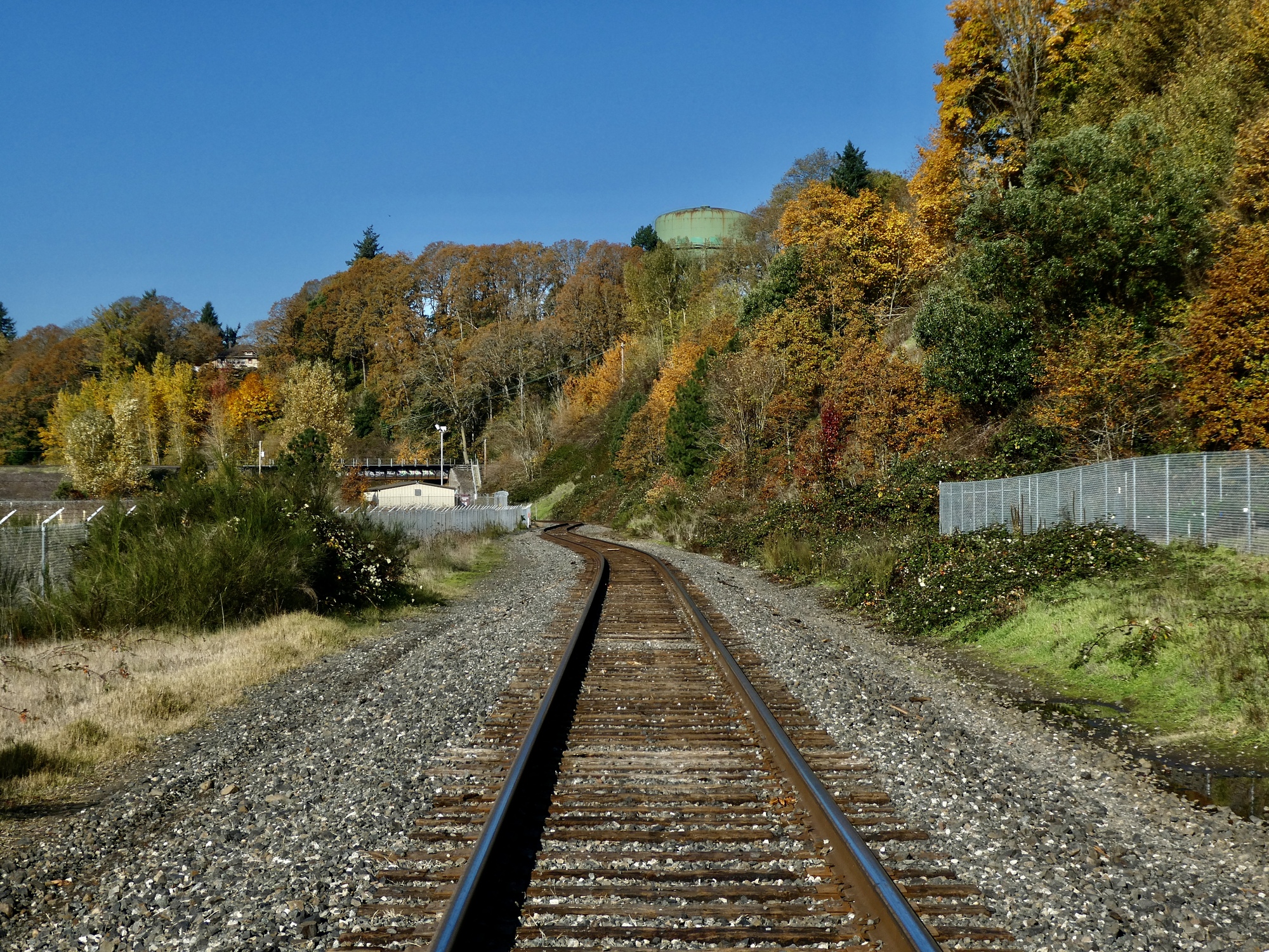
A half hour later I’m parking the Raven across the street from Cathedral Coffee (another fine place I should stop in at again) and walk across to Edgewater Avenue. It doesn’t take long to see why I’ve never noticed it before, because it’s a poorly surfaced road that drops steeply down the hill and looks more like an alley. And once I round the first bend I come to a barricade. The road is closed to cars, and the surface is buried in bigleaf maple leaves. I’m really getting excited now - this looks great.


| Heart | 3 | Comment | 0 | Link |

| Heart | 4 | Comment | 0 | Link |
As it turns out though, there’s another reason I’ve never heard of Edgewater Avenue - it doesn’t really exist. After it bottoms out and crosses beneath the train bridge it abruptly ends. Ahead is just the rail line, and the narrow, sometimes grassy, sometimes rocky, sometimes puddly margin. And on the right is a chain link fence, with a sign warning people to keep out because it’s a health hazard. I haven’t discovered what the situation is here but it’s looking like this is an abandoned and razed former industrial site that’s now a toxic waste site. And it looks like beyond this point Edgewater Avenue is a nonexistent relic of the past that presumably once led to the now nonexistent facility. Who knows why eBird calls this Harbor View Park, because it’s certainly no park now.


| Heart | 3 | Comment | 0 | Link |
I study the map and look ahead, trying to gauge whether I can get through and should go forward or turn back. I take heart when I see a Samoyed pulling his man down the tracks and learn that I can get through to the other side so I continue on. As I walk down these apparently abandoned tracks, sometimes walking the ties and sometimes on either side depending on where the best surface is, I’m reminded of my youth in Seattle when I would walk the rails on the abandoned rail line near our house, the line that’s since been ripped up to create the Burke-Gilman Trail. I made it a personal challenge to see if I could balance myself on the rails all the way between one block and the next, something I’m tempted to try again today for sentimental reasons but think better of.
It’s not much of a walk today to be honest, but I enjoy seeing the railroad bridge from a new perspective. And eventually I come out the other end and find pavement again on the road that drops down to the UP soccer field.

| Heart | 3 | Comment | 0 | Link |


| Heart | 2 | Comment | 0 | Link |
The Samoyed guy is right - it’s a pretty steep climb from the soccer field up to the top on Bluff Street. It’s not one I’ll be tempted to return to with the bike, particularly since there’s no park at the bottom. On the way up a watch enviously as a soccer player late for practice is running down this precipitous slope to the field, remembering how much I loved running like that when I was a cross-country runner back in high school and college. I wonder how his knees will be in another fifty years?
As I climb, I get a better if more distant view of the bridge. I also note that there are many gulls clustered on the edge of the river near the base of the bridge, confirming that it probably really is a good birding spot as long as you can get there - by boat, probably.

| Heart | 4 | Comment | 0 | Link |

Once on top, I come out at the northern edge of the UP campus. From here it’s a straight-forward walk back to the car a mile or so to the north, though I get as far as I can by staying on side streets and alleys. When I cross the railroad bridge I look down to the graffiti-scrawled underpass I walked through an hour earlier, and note with surprise that there’s a freight train rolling down the rails I had thought we’re abandoned. And I look out, wondering about that gap to the right of the fence below the bridge. I wonder if I could get through to the water that way? I may have to come back for a second try.

| Heart | 1 | Comment | 0 | Link |

| Heart | 3 | Comment | 2 | Link |
5 months ago
5 months ago
| Rate this entry's writing | Heart | 12 |
| Comment on this entry | Comment | 3 |
Although, the situation you described makes me wonder who is the boofiest of the duo(?)
5 months ago
5 months ago
I remember this exchange:
Scott - "So, two weeks left."
Me - I stare
Scott - "Less than two weeks."
Me - I stare harder.
Scott - Ponders
Me - "And you're our ride to the airport this Sunday?"
5 months ago