The Kings Valley loop - Northwest passages: riding out the storm - CycleBlaze

June 4, 2020

The Kings Valley loop

There are plenty of fine rides we can take right from our new home in downtown Corvallis.  For our first ride though we decided on a loop further afield.  We ran out of gas unpacking last night and just left the bikes in the car overnight, so since they were already loaded, we decided it made sense to take advantage of it.

Today’s loop starts from the parking lot in Buena Vista Park, on the west bank of the Willamette just above the ferry crossing.  It’s like Old Home Week for us when we arrive - we always crossed the river on this ferry when we biked down to Corvallis and back, a 70 mile loop that we took once or twice a year when we lived down here.

Starting out from Buena Vista Park.
Heart 3 Comment 0

For the next ten miles we cross the west side of the valley, heading west toward Kings Valley by way of Suver and Airlie.  Such a contrast to the roads we’ve been cycling for the last two months, as we bike past miles of cultivated fields growing an amazing variety of crops.  It all feels so instantly familiar - this is the country where Team Anderson first took root over 30 years ago.

Leaving the park, we face a gentle climb as we leave the river behind.
Heart 3 Comment 0
Crossing the Little Luckiamute River on Corvallis Road. Many years ago I canoed down this lazy river with a friend, Jerry Rosenkoetter.
Heart 3 Comment 0
Image not found :(
Looking west toward the coast range, from somewhere east of Suver. So what is this white-blossomed crop, anyway?
Heart 3 Comment 5
Bill ShaneyfeltGot a detailed photo? Possibly some kind of Brassica (mustard family)...
Reply to this comment
3 years ago
Scott AndersonTo Bill ShaneyfeltComing soon, to@ blog entry near you.
Reply to this comment
3 years ago
Bill ShaneyfeltTo Scott AndersonWaiting! :-)
Reply to this comment
3 years ago
Andrea BrownIt might be buckwheat. A closeup will be very helpful (with leaves).
Reply to this comment
3 years ago
Bruce Lellman
I'm voting for Buckwheat.
Reply to this comment
3 years ago
Westbound on Suver Road.
Heart 6 Comment 0
Image not found :(
North of Suver. This part of the valley makes for especially lovely cycling, with generally flattish roads broken up by low hills and gentle climbs - just enough to give contrast and a bit of a view.
Heart 4 Comment 0
Image not found :(
I like the paint scheme of these hives - they blend in so well with the background.
Heart 3 Comment 0
West of Suver, we approach the first low ridge of the coast range. Kings Valley is on the other side, a lazy 600’ climb away.
Heart 3 Comment 0

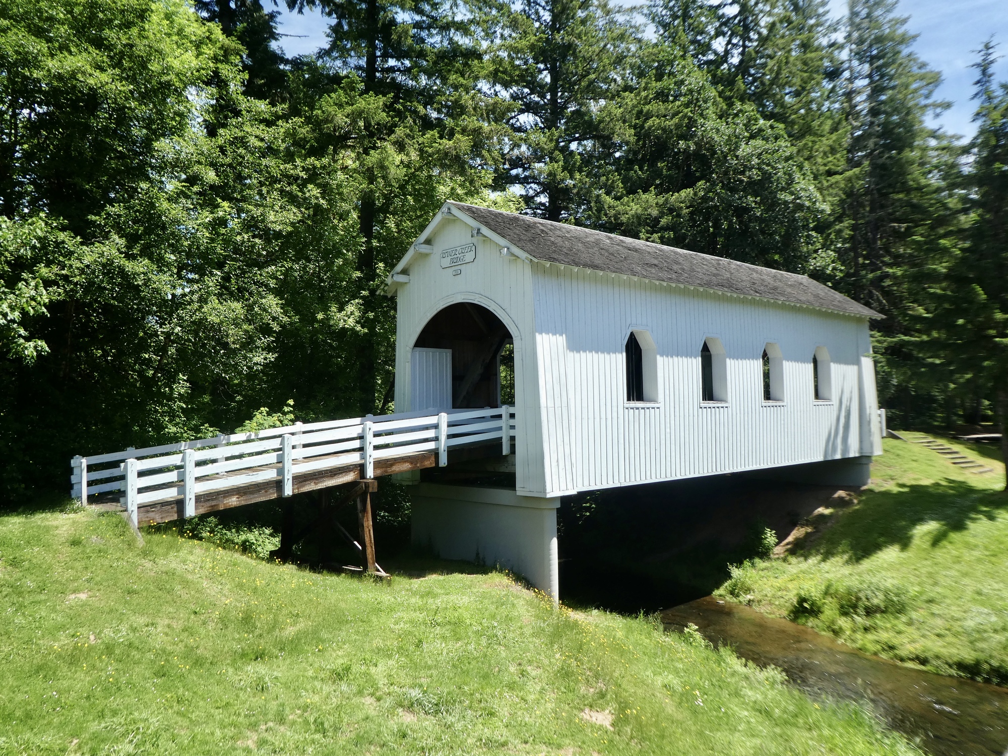
About ten miles into the ride we come to Airlie, and the base of a low climb over one of the low ridges at the frontier of the coast range.  This is pretty rumpled country here, with low hills hacked up by creeks and hollows.  We’ve got about  600’ climb ahead, rising out of the farmland into a mixed deciduous-conifer forest.  Over the top, we have a delightful descent along Maxfield Creek down to the Kings Valley Highway.

Kings Valley Highway runs from Dallas south to Wren, where it intersects with Highway 20, the cross state highway that runs from the coast through Corvallis.  KV is a very scenic ride, in this section generally following the Luckiamute River north through its narrow valley, surrounded by low hills on both sides.  Small farm holdings alternate with mysterious, mossy hemlock forests.  I don’t really care for it so much as a cycling route though.  It’s narrow, winding, two lane, just a bit chancy.  You’ll see an occasional logging truck coming round the bend ahead of you, just often enough to make you wonder.  Today though it’s as quiet as I’ve ever seen it, and quite nice.

I forgot to bring any lunch Or even a snack with me, so we stop in at Kings Valley Store for a quick break.  While we’re there, Rachael overhears the conversation of the locals as they discuss the events of the week.  We’re reminded again of what a diverse state Oregon is.  Fifteen miles outside of sophisticated, peaceful Corvallis and we’re in country that feels closer in spirit to John Day.

Nearing Airlie, we start leaving the valley behind and approach the lowest foothills of the coast range. This is wine country - Airlie Winery is one of the oldest labels in the valley.
Heart 4 Comment 0
Sauerkraut Road. I stopped for the barn, but mostly I just liked the name of the road.
Heart 5 Comment 0
Kings Valley Community Church.
Heart 3 Comment 0
Northbound on the Kings Valley Highway.
Heart 3 Comment 0

After lunch we continued north on the Kings Valley Highway until leaving it a few miles south of Dallas to turn east on the Monmouth Highway.   Leaving the Luckiamute River, we climb rather steeply over a low ridge; lose it all when we drop back to Copper Creek; and then repeat the climb with a similar ascent over Fishback Ridge.  From the top of the final summit we enjoy a wide view east to the South Salem Hills, with Mount Jefferson far in the distance.

The final fifteen miles are a breeze, as we drop to the outskirts of Monmouth and turn south for a fast, flat downwind cruise back to the ferry.

This was a complete surprise. There are quite a few covered bridges in the mid-valley, and we have been planning on visiting several while we’re down here. I didn’t know about this one though.
Heart 5 Comment 0
The Ritter Creek Bridge, a Howe truss design, was built in 1927 at the spot where this photo is taken from. It was relocated in 1976 when the current concrete bridge was built. It is notable for being the last covered bridge built on a state highway in Oregon.
Heart 5 Comment 0
Pioneer wrecks have a different look over here than east of the mountains. They look like they’re slowly being reclaimed by the land.
Heart 4 Comment 1
Andrea BrownThere are very few that are visible, generally completely covered by blackberries.
Reply to this comment
3 years ago
Northbound on Kings Valley Rod, south of Pedee.
Heart 2 Comment 0
In Pedee, a tiny unincorporated place. I haven’t been able to find much information about Pedee, other than that it was named after the Pedee River in South Carolina. Depot Street is suggestive though . Southern Pacific ran a line from Dallas to Airlie that shut down in 1927, so maybe this is the old depot.
Heart 3 Comment 3
Andrea BrownThey make jeans in Pedee! https://www.pedeejeans.com/store/c1/Featured_Products.html
Reply to this comment
3 years ago
Scott AndersonTo Andrea BrownWhat a great discovery! Did you know this already?
Reply to this comment
3 years ago
Andrea BrownTo Scott AndersonI lived in Corvallis for 15 years. Pedee Jeans were a hot thing there, coveted by all those forestry types.
Reply to this comment
3 years ago
Daisies, Kings Valley.
Heart 3 Comment 0
Image not found :(
Willamette Valley is remarkable for its crop diversity. We biked past acres of wheat, rye, mint, hazelnuts, grapes, row crops, canola, and that mysterious white crop again today.
Heart 3 Comment 0
Dropping back toward the Willamette. In the distance are the South Salem Hills.
Heart 2 Comment 0
A beautiful land, in a beautiful season.
Heart 2 Comment 0

Video sound track: Sondho (Dream), by Nandi Lauria

Heart 1 Comment 0

Ride stats today: 50 miles, 1,400’

Rate this entry's writing Heart 7
Comment on this entry Comment 4
Bob DistelbergThe landscape, especially in the video, very much reminds me of where I grew up in upstate New York. Same kind of rolling landscape, farm fields and hills in the background. Beautiful.
Reply to this comment
3 years ago
Jen RahnThose white fields!

What a beautiful ride.
Reply to this comment
3 years ago
Scott AndersonTo Jen RahnThey’re pretty outstanding, alright. I need to take a closer look at one of these plants the next time we’re out so Bill or Andrea can identify it.
Reply to this comment
3 years ago
Scott AndersonTo Bob DistelbergI’m glad to hear that. We’ve never biked through upstate NY, other than eight alongside Lake Champlain, but I’ve wanted to for years. We’ve been waiting for the right autumn to head back there and see the season turn.
Reply to this comment
3 years ago