March 28, 2020
Picture Gorge
We pick up today where we left off yesterday - in Dayville, westbound on U.S. Route 26/the TransAmerica Trail. This is an especially scenic stretch, passing through Picture Gorge and then continuing west up Rock Creek, one of the larger of the John Day’s many tributaries.
This wasn’t the ride plan though when we left the house this morning. It’s still cold here today so we’re still staying with lower elevation downriver rides. We planned to drive to Kimberley where we ended our first ride, the one through the National Monument. From there we were going to bike west toward Service Creek, the western end point of the nearly hundred mile long stretch of the John Day that has a generally flattish highway following it. Beyond Service Creek the John Day continues west through a large roadless area while the highway bends north and up into the mountains toward Fossil, on another gorgeous stretch of road that will have to wait for a warmer month.
The road from Kimberly to Service Creek will make a fine ride, and I expect we’ll see it soon. Today though, as we look at what is an unexpectedly sunny morning, we opt for the ride through Picture Gorge. I had wanted to save this for a fair day because I knew how dramatic it would be, and suddenly today looks like the perfect time. Even better, it’s the weekend. There shouldn’t be any large trucks crowding and alarming us as we snake through narrow, gnarly picture gorge.
We park Old Paint on the first decent pullout we come to on the outskirts of Dayville and start biking west. It’s about seven miles from Dayville to the mouth of the gorge, through country very like what we biked through yesterday.

| Heart | 3 | Comment | 0 | Link |

| Heart | 2 | Comment | 0 | Link |

| Heart | 2 | Comment | 0 | Link |

| Heart | 3 | Comment | 0 | Link |

| Heart | 2 | Comment | 0 | Link |
I’ve ridden through Picture Gorge twice before: once 35 years ago on my ride to Baker (now Baker City), and again in 2007 on a five day figure eight from Spray. My memory of it is pretty hazy, but Rachael and I have a fresher, scarier memory from our drive down from The Dalles last week. As soon as we entered the gorge we encountered a large semi coming the other way through the narrow, twisting, shoulderless canyon road. We didn’t even like driving past the truck, much less having one pass us while biking. Rachael was pretty sure we’d never bike through here until we later realized how little traffic there is.
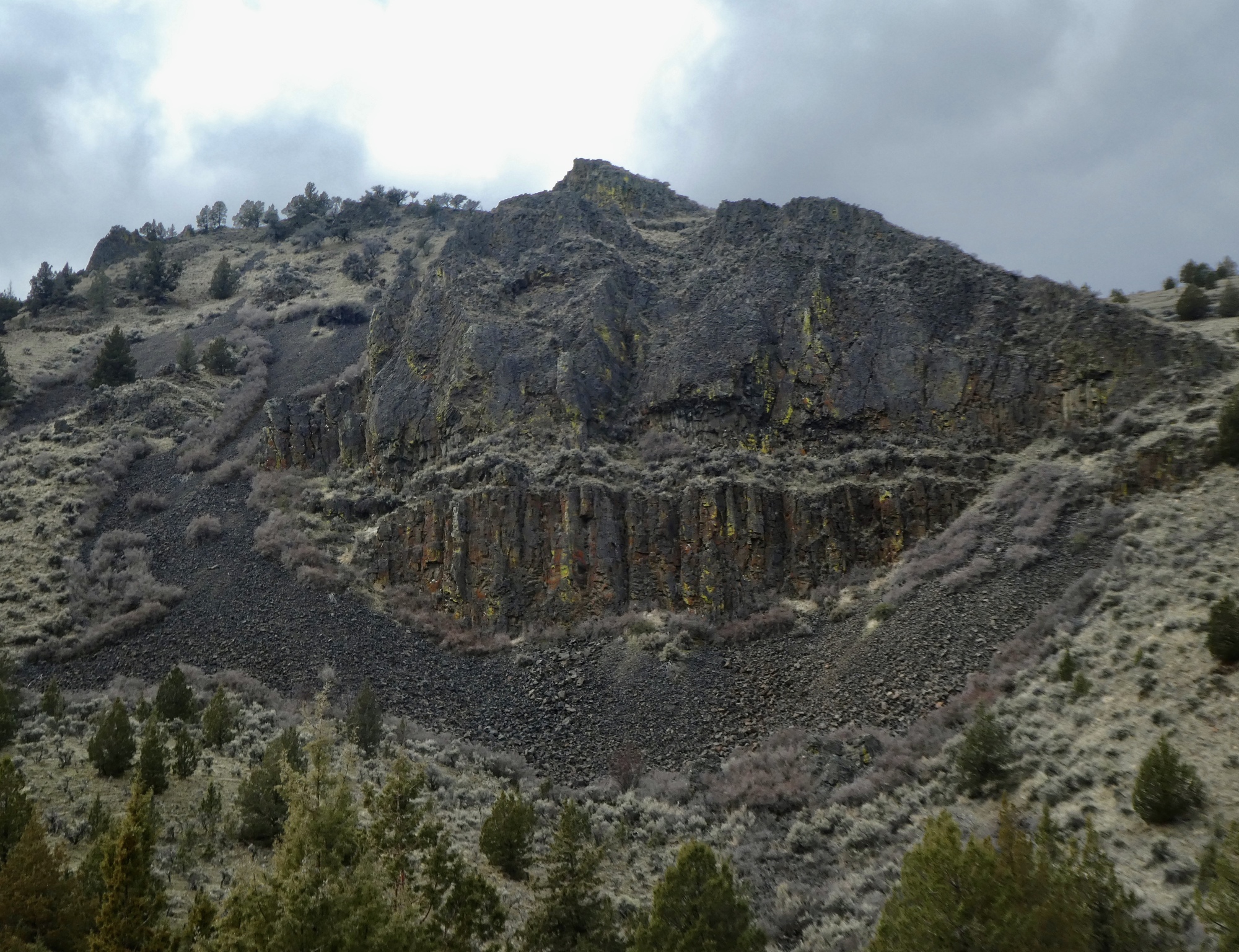
Today we’ve almost got the road to ourselves so it’s not at all scary. There are regular pull-outs on the gravel shoulder every few hundred yards, and you can hear oncoming vehicles in plenty of time to just get off the road. It’s easy to stop almost anywhere and look up in wonder at the basalt cliffs towering nearly a thousand feet above the river.
As so often happens though, I learn something new when writing up the day. I thought the gorge got its name because it is so picturesque. Nope. It’s because of the pictures! The gorge contains Native American pictographs that are over 200 years old. Obviously we have to come back.

| Heart | 2 | Comment | 0 | Link |

| Heart | 4 | Comment | 0 | Link |

| Heart | 4 | Comment | 0 | Link |

About halfway through the gorge we come to the T-junction with Route 19, the road that follows the John Day as it sharply bends north toward Kimberly. This is the road we followed on our first ride here, when we parked the car a few hundred yards north of the junction. Today though we continue west on Highway 26, following Rock Creek upriver toward its source in the high plateau between here and Mitchell.
We don’t really have a distance or specific destination in mind. We’ve put ourselves into a time-gumption box. We’ll turn back by 1:45 or by when we get tired of climbing, whichever comes first.
I don’t remember this stretch of road from when I passed through 35 years ago on my way to Baker, but it’s a surprisingly great ride. After a flattish mile or two along a slender pasture the road starts climbing gently but steadily. Rachael continues on for about 12 miles past the gorge before reaching the time limit and turning back. She picks me up only a mile behind her - I’ve biked a bit more steadily for a change, only stopping for a few photos along the way.
I was surprised profiling this road to see for how long the climb extends from this direction and how modest it is the whole way. From the junction with Route 19 it climbs 25 miles to Keyes Creek Summit before dropping steeply to Mitchell on the other side of the pass. When we come back to see Picture Gorge again, a good plan would be to park at the west end of the gorge and bike to this summit and back.

| Heart | 2 | Comment | 0 | Link |

| Heart | 2 | Comment | 0 | Link |


| Heart | 4 | Comment | 0 | Link |

| Heart | 1 | Comment | 0 | Link |
| Heart | 3 | Comment | 0 | Link |
We’re up at about 3,500’ when Rachael comes riding around the mountain, riding her grey-green Surley when she comes. It’s cold, quite windy, and the sky is darkening fast. We start wondering if we might get wet so we quickly bolt down another light roadside meal and start biking back toward the Jetta.
The ride back is exhilarating, as we drop 1,300’ feet to the gorge over the next twelve miles in a fast rewind of the climb we just completed. It’s more dramatic in this direction with the distant Strawberry and Aldrich Mountains showing occasionally through the gap ahead. We enjoy a tailwind all the way, so we’re really flying (by our standards anyway - we’re just speed-weenies).
Back through the gorge again, it’s even quieter this time. We’re still going downhill and downwind and are only passed by two small cars in the two mile long gorge. Out the other side it’s a different story as we encounter a headwind for the last seven miles back to Dayville. We keep a good pace though and soon see the west end of town just ahead, happy to be arriving dry.

| Heart | 1 | Comment | 0 | Link |


| Heart | 1 | Comment | 0 | Link |
Video sound track: Sonho (Dream), by Nando Lauria
So I think we’ll just stop here for now. We’ve enjoyed an outstanding 44 mile ride (or 42, but who’s counting?). We’re still a mile from the car yet, but let’s save the story of that last mile for a rainy or snowy day when we’re shut in by the weather. There’s some stormy weather just ahead, so we might as well save some material to talk about then.

| Heart | 3 | Comment | 0 | Link |
| Rate this entry's writing | Heart | 8 |
| Comment on this entry | Comment | 5 |
4 years ago
Makes me want to go back in spring or fall.
We rode through on a very early summer morning to beat the 100+ afternoon heat, so I'm sure we didn't take the time needed to really let our jaws drop and take it all in before we continued up the hill to Mitchell.
4 years ago
4 years ago